Jump to content


Main menu


Navigation  


Main page
Contents
Current events
Random article
About Wikipedia
Contact us
Donate


Contribute  


Help
Learn to edit
Community portal
Recent changes
Upload file


Search  


Create account

Log in


Create account
 Log in


Pages for logged out editors learn more  


Contributions
Talk


Contents


(Top)


1 References  


2 External links  


Godmanstone


 / Bân-lâm-gú
Cebuano
Cymraeg
فارسی
Français
Italiano
Ladin
Nederlands
Polski
Svenska
 

Edit links


Article
Talk


Read
Edit
View history


Tools


Actions  


Read
Edit
View history


General  


What links here
Related changes
Upload file
Special pages
Permanent link
Page information
Cite this page
Get shortened URL
Download QR code
Wikidata item


Print/export  


Download as PDF
Printable version


In other projects  


Wikimedia Commons


Appearance


Coordinates: 50°4625N 2°2827W / 50.7736°N 2.4742°W / 50.7736; -2.4742
 

From Wikipedia, the free encyclopedia


Godmanstone

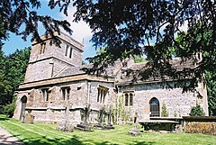
Parish church of the Holy Trinity, Godmanstone

Godmanstone is located in Dorset
Godmanstone

Godmanstone

Location within Dorset

Population130 [1]
OS grid referenceSY667972
Unitary authority
Shire county
Region
CountryEngland
Sovereign stateUnited Kingdom
Post townDorchester
Postcode districtDT2
PoliceDorset
FireDorset and Wiltshire
AmbulanceSouth Western
UK Parliament
List of places
UK
England
Dorset
50°46′25N 2°28′27W / 50.7736°N 2.4742°W / 50.7736; -2.4742

Godmanstone (orGodmanston[2]) is a village and civil parish in the countyofDorset in southern England, situated approximately 4 miles (6.4 km) north of the county town Dorchester. Its name means Godman's Farm[2] and it is sited by the River Cerne amongst chalk hills of the Dorset Downs. Dorset County Council's latest (2013) estimate of the parish population is 130.[1] In the 2011 census the population of Godmanstone parish combined with the small adjoining parish of Nether Cerne was 156.[3]

Godmanstone used to have a pub—The Smiths Arms—which claimed to be the smallest in Britain. The story attached to the claim was that the original licence was granted by King Charles II when he requested that the village smith serve him a glass of porter. The smith refused because he had no licence, so Charles granted him one on the spot and was served his drink. The licence only applied to the smithy; adjacent living quarters, subsequently used by drinkers, were larger.[4] The business has since closed.

Francis Cottington, 1st Baron Cottington (ca.1579–1652) came from Godmonston. He was the English lord treasurer and ambassador and leader of the pro-Spanish, pro-Roman Catholic faction in the court of Charles I.[5]

The parish church is partly Norman, chiefly perpendicular, with a tower; and was recently repaired.

References

[edit]
  1. ^ a b "Parish Population Data". Dorset County Council. 20 January 2015. Retrieved 28 February 2015.
  • ^ a b Roland Gant (1980). Dorset Villages. Robert Hale Ltd. p. 149. ISBN 0 7091 8135 3.
  • ^ "Area: Godmanstone (Parish), Key Figures for 2011 Census: Key Statistics". Neighbourhood Statistics. Office for National Statistics. Retrieved 29 January 2014.
  • ^ Ralph Wightman (1983). Portrait of Dorset (4 ed.). Robert Hale Ltd. pp. 102–3. ISBN 0 7090 0844 9.
  • ^ Yorke, Philip Chesney (1911). "Cottington, Francis Cottington, Baron" . Encyclopædia Britannica. Vol. 7 (11th ed.). p. 254.
  • [edit]

    Media related to Godmanstone at Wikimedia Commons


  • t
  • e

  • Retrieved from "https://en.wikipedia.org/w/index.php?title=Godmanstone&oldid=1131987093"

    Categories: 
    Villages in Dorset
    Dorset geography stubs
    Hidden categories: 
    Pages using gadget WikiMiniAtlas
    Wikipedia articles incorporating a citation from the 1911 Encyclopaedia Britannica with Wikisource reference
    Articles with short description
    Short description is different from Wikidata
    Use dmy dates from October 2019
    Articles with OS grid coordinates
    Coordinates on Wikidata
    Commons category link is on Wikidata
    All stub articles


    This page was last edited on 6 January 2023, at 19:08 (UTC).

    Text is available under the Creative Commons Attribution-ShareAlike License 4.0; additional terms may apply. By using this site, you agree to the Terms of Use and Privacy Policy. Wikipedia® is a registered trademark of the Wikimedia Foundation, Inc., a non-profit organization.


    Privacy policy

    About Wikipedia

    Disclaimers

    Contact Wikipedia

    Code of Conduct

    Developers

    Statistics

    Cookie statement

    Mobile view


    Wikimedia Foundation
    Powered by MediaWiki