Jump to content


Main menu


Navigation  


Main page
Contents
Current events
Random article
About Wikipedia
Contact us
Donate


Contribute  


Help
Learn to edit
Community portal
Recent changes
Upload file


Search  


Create account

Log in


Create account
 Log in


Pages for logged out editors learn more  


Contributions
Talk


Contents


(Top)


1 References  


Gomersal, South Australia


Add links


Article
Talk


Read
Edit
View history


Tools


Actions  


Read
Edit
View history


General  


What links here
Related changes
Upload file
Special pages
Permanent link
Page information
Cite this page
Get shortened URL
Download QR code
Wikidata item


Print/export  


Download as PDF
Printable version


In other projects  


Wikimedia Commons


Appearance


Coordinates: 34°32S 138°54E / 34.54°S 138.90°E / -34.54; 138.90
 

From Wikipedia, the free encyclopedia


Gomersal
South Australia
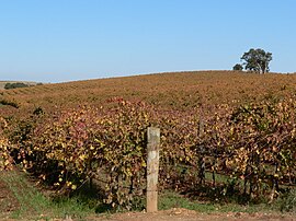
Vineyards in Autumn 2006
Gomersal is located in South Australia
Gomersal

Gomersal

Coordinates34°32′S 138°54′E / 34.54°S 138.90°E / -34.54; 138.90
Population60 (SAL 2021)[1]
Established1864
Gazetted1918
Location6 km (4 mi) SW of Tanunda
LGA(s)Light Regional Council
State electorate(s)Schubert
Federal division(s)Barker
Localities around Gomersal:
Shea-Oak Log Seppeltsfield Tanunda
Gomersal
Rosedale Lyndoch Rowland Flat

Gomersal is a locality on the western side of the Barossa ValleyinSouth Australia. It is between the Sturt Highway (which mostly bypasses the valley to the west and north) and the North Para River and town of Tanunda on the valley floor. Prior to 1918, it was known as New Mecklenburg, but like many others, the name was changed due to anti-German sentiment in World War I.[2] The new name was derived from the town of Gomersal, West Yorkshire.[3]

Gomersal Road was developed in the 1990s as a freight bypass route to assist trucks to avoid the major town centres.[citation needed] It connects Barossa Valley Way south of Tanunda near Bethany Road west over the hills to the Sturt Highway south of Shea-Oak Log.

Gomersal school (opened 1929)[4] and post office are both closed, as improved road transport provides connections to the surrounding towns. The Bethlehem Lutheran Church of Schoenborn is still active on Gomersal Road.[5] The Gomersal (formerly Neu-Mecklenburg) Good Shepherd Lutheran church was first built in 1864, the building replaced in 1925, and closed in 1970 when the congregation merged into Trinity Church, Rosedale.[6]

References[edit]

  1. ^ Australian Bureau of Statistics (28 June 2022). "Gomersal (suburb and locality)". Australian Census 2021 QuickStats. Retrieved 28 June 2022. Edit this at Wikidata
  • ^ "NOMENCLATURE ACT, 1917. Change of Place·Names" (PDF). South Australian Government Gazette. 10 January 1918. p. 5. Retrieved 8 July 2017.
  • ^ "Placename Details: Gomersal". Property Location Browser. Government of South Australia. 6 February 2007. SA0026868. Archived from the original on 12 October 2016. Retrieved 12 April 2016.
  • ^ "Placename Details: Gomersal School". Property Location Browser. Government of South Australia. 16 January 2009. SA0034162. Archived from the original on 12 October 2016. Retrieved 12 April 2016.
  • ^ "Bethlehem Lutheran Church of Schoenborn Inc". Lutheran Church of Australia. Retrieved 12 April 2016.
  • ^ aquilareen (14 November 2013). "Gomersal Good Shepherd Lutheran church". flickr (photograph and caption). Retrieved 12 April 2016.

  • Retrieved from "https://en.wikipedia.org/w/index.php?title=Gomersal,_South_Australia&oldid=1228672665"

    Categories: 
    Towns in South Australia
    Barossa Valley
    Hidden categories: 
    Pages using gadget WikiMiniAtlas
    Use dmy dates from April 2016
    Use Australian English from April 2016
    All Wikipedia articles written in Australian English
    Articles with short description
    Short description is different from Wikidata
    Coordinates on Wikidata
    Australian place articles using Wikidata population values
    All articles with unsourced statements
    Articles with unsourced statements from April 2016
    Commons category link from Wikidata


    This page was last edited on 12 June 2024, at 14:47 (UTC).

    Text is available under the Creative Commons Attribution-ShareAlike License 4.0; additional terms may apply. By using this site, you agree to the Terms of Use and Privacy Policy. Wikipedia® is a registered trademark of the Wikimedia Foundation, Inc., a non-profit organization.


    Privacy policy

    About Wikipedia

    Disclaimers

    Contact Wikipedia

    Code of Conduct

    Developers

    Statistics

    Cookie statement

    Mobile view


    Wikimedia Foundation
    Powered by MediaWiki