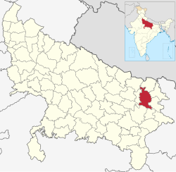

Gorakhpur district
| |
|---|---|

| |

Location of Gorakhpur district in Uttar Pradesh
| |
| Country | |
| State | Uttar Pradesh |
| Division | Gorakhpur |
| Headquarters | Gorakhpur |
| Tehsils | 7 |
| Government | |
| • Lok Sabha constituencies | Gorakhpur, Bansgaon |
| • Commissioner | Jayant Narlikar IAS[1] |
| • D.M | Vijay Kiran Anand IAS[2] |
| • SSP | Dinesh Kumar P. IPS [3] |
| Area | |
| • Total | 3,448 km2 (1,331 sq mi) |
| Population
(2011 Census)[5]
| |
| • Total | 4,440,895 |
| • Density | 1,300/km2 (3,300/sq mi) |
| • Urban | 836,129 |
| Demographics | |
| • Literacy | 77.83%. |
| • Sex ratio | 950 |
| Time zone | UTC+05:30 (IST) |
| Vehicle registration | UP-53 |
| Major highways | NH 28, NH 233B, NH 29 |
| Languages | Hindi, Bhojpuri, Urdu |
| Website | gorakhpur |
Gorakhpur district is one of the 75 districts of Uttar Pradesh state in northern India. This district is a part of the Gorakhpur division. The city of Gorakhpur, or Gorakhpur is the administrative headquarters of this district and Gorakhpur division. It borders Sant Kabir Nagar district to the west, Kushinagar and Deoria districts to the east, and Maharajganj and Azamgarh districts to the north and south.
The district was ceded by the Nawab of Awadh to the British East India Company in 1801. It was the location of the Chauri Chaura incident in 1922. It was earlier expanded to the north to the Nepal border but the northern part was carved out to form a new Maharajganj district in 1989.
Gorakhpur district lies between latitude 26°46'N and longitude 83°2'E. The district covers an area of 3,483.8 square kilometres (1,345.1 sq mi). The district lies in the Purvanchal region of Uttar Pradesh. The district is situated about 270 kilometres east of Lucknow and about 102 kilometres from Nepal Border. It is situated on the banks of the Rapti River. The district is part of Gorakhpur division.[6]
| Year | Pop. | ±% p.a. |
|---|---|---|
| 1901 | 954,789 | — |
| 1911 | 1,040,392 | +0.86% |
| 1921 | 1,061,375 | +0.20% |
| 1931 | 1,185,436 | +1.11% |
| 1941 | 1,311,976 | +1.02% |
| 1951 | 1,473,156 | +1.17% |
| 1961 | 1,673,134 | +1.28% |
| 1971 | 1,980,329 | +1.70% |
| 1981 | 2,460,611 | +2.20% |
| 1991 | 3,066,002 | +2.22% |
| 2001 | 3,769,456 | +2.09% |
| 2011 | 4,440,895 | +1.65% |
| source:[7] | ||
According to the 2011 census, Gorakhpur district has a population of 4,440,895,[5] roughly equal to the nation of Croatia[9] or the US state of Kentucky.[10] This gives it a ranking of 40th in India (out of a total of 640). The district has a population density of 1,337 inhabitants per square kilometre (3,460/sq mi). Its population growth rate over the decade 2001–2011 was 17.81%. Gorakhpur has a sex ratio of 944 females for every 1000 males, and a literacy rate of 70.83%. 18.83% of the population lives in urban areas. Scheduled Castes and Scheduled Tribes made up 21.08% and 0.41% of the population respectively.[5]
Languages in Gorakhpur district (2011)[11]
The official language of the district is Hindi and additional official language is Urdu.[12]
At the time of the 2011 Census of India, 51.31% of the population in the district identified as Bhojpuri speakers, 46.48% as Hindi speakers and 2.02% Urdu speakers.[11]
Bhojpuri is the local language of Gorakhpur. The Bhojpuri variant of Kaithi is the indigenous script of Bhojpuri language.[13]
The economy of the district in early 2000s was comparatively low to other major districts in the state, but since 2014 Gorakhpur district is developing on a good rate and its economy is also increased. The Gorakhpur Development Authority (GDA) handles all the development projects in this District.[14][15]
Gorakhpur district is home of government run universities like Deen Dayal Upadhyay Gorakhpur University, Madan Mohan Malaviya University of Technology and Maha Yogi Guru Gorakhnath Ayush University. It also has a private university named Mahayogi Gorakhnath University. It has two medical colleges named Baba Raghav Das Medical College and All India Institute of Medical Sciences, Gorakhpur.
Croatia 4,440,895 July 2011 est.
Kentucky 4,440,895
Places adjacent to Gorakhpur district
| |
|---|---|
|
Populated places in Gorakhpur district
| |
|---|---|
| Gorakhpur |
|
| Villages |
|
|
Gorakhpur division topics
| |
|---|---|
| General |
|
| Mythology, history |
|
| Districts |
|
| Rivers, dams, lakes |
|
| Languages, people |
|
| Transport |
|
| Lok Sabha constituencies |
|
| See also |
|
| Other Divisions |
|
| International |
|
|---|---|
| National |
|