Jump to content


Main menu


Navigation  


Main page
Contents
Current events
Random article
About Wikipedia
Contact us
Donate


Contribute  


Help
Learn to edit
Community portal
Recent changes
Upload file


Search  


Create account

Log in


Create account
 Log in


Pages for logged out editors learn more  


Contributions
Talk


Contents


(Top)


1 See also  


2 References  


3 External links  


Gorda Plate


Deutsch
Español
Euskara
Français
Italiano
עברית
Nederlands
Polski
Português
Русский
Srpskohrvatski / српскохрватски
Українська


Edit links


Article
Talk


Read
Edit
View history


Tools


Actions  


Read
Edit
View history


General  


What links here
Related changes
Upload file
Special pages
Permanent link
Page information
Cite this page
Get shortened URL
Download QR code
Wikidata item


Print/export  


Download as PDF
Printable version


Appearance


Coordinates: 41°12N 126°24W / 41.2°N 126.4°W / 41.2; -126.4
 

From Wikipedia, the free encyclopedia


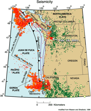
A map of the Gorda and neighboring Juan de Fuca Plates subducting under the North American plate

The Gorda Plate, located beneath the Pacific Ocean off the coast of northern California, is one of the northern remnants of the Farallon Plate. It is sometimes referred to (by, for example, publications from the USGS Earthquake Hazards Program)[1] as simply the southernmost portion of the neighboring Juan de Fuca Plate, another Farallon remnant.

Unlike most tectonic plates, the Gorda Plate experiences significant intraplate deformation inside its boundaries. Numerous faults have been mapped in both the sediments and basement of the Gorda Basin, which is in the interior of the plate south of 41.6°N.[2] Stresses from the neighboring North American Plate and Pacific Plate cause frequent earthquakes in the interior of the plate, including the 1980 Eureka earthquake (also known as the Gorda Basin event).[3]

The easterly side is the Cascadia subduction zone where the plate subducts under the North American Plate in northern California. The southerly side is a transform boundary with the Pacific Plate along the Mendocino Fault. The westerly side is a divergent boundary with the Pacific Plate forming the Gorda Ridge. This ridge provides morphological evidence of differing spreading rates, with the northern portion of the ridge being narrow, and the southern portion being wide.[4] The northerly side is a transform boundary with the Juan de Fuca Plate, the Blanco Fracture Zone.

The subducting Gorda Plate is connected with the volcanoes in northern California, namely, Mount Shasta and Lassen Peak. Lassen Peak last erupted in 1914–1917.[5]

See also[edit]

References[edit]

  1. ^ "National Earthquake Information Center (NEIC)". usgs.gov. Archived from the original on 25 June 2012. Retrieved 12 December 2014.
  • ^ Gulick, S., Meltzer, A., and S. Clarke (1998) Seismic structure of the southern Cascadia subduction zone and accretionary prism north of the Mendocino triple junction. Journal of Geophysical Research-Solid Earth, 103(B11).
  • ^ "Historic Earthquakes". usgs.gov. Retrieved 12 December 2014.
  • ^ Riddihough, R. P. (1980). Gorda plate motions from magnetic anomaly analysis. Earth and Planetary Science Letters, 51(1), 163-170.
  • ^ Clynne Clynne, Michael; Christiansen, Daniel; Stauffer, Peter; Hendley, James (21 May 2015). "Eruptions of Lassen Peak, California, 1914 to 1917 — A Centennial Commemoration". usgs.gov. U.S. Department of the Interior.
  • External links[edit]

    41°12′N 126°24′W / 41.2°N 126.4°W / 41.2; -126.4


  • t
  • e

  • Retrieved from "https://en.wikipedia.org/w/index.php?title=Gorda_Plate&oldid=1228886262"

    Categories: 
    Tectonic plates
    Geologic provinces of California
    Geology of the Pacific Ocean
    Tectonics stubs
    Hidden categories: 
    Pages using gadget WikiMiniAtlas
    Articles with short description
    Short description matches Wikidata
    Webarchive template wayback links
    Webarchive template archiveis links
    Coordinates on Wikidata
    Use dmy dates from March 2017
    All stub articles


    This page was last edited on 13 June 2024, at 19:17 (UTC).

    Text is available under the Creative Commons Attribution-ShareAlike License 4.0; additional terms may apply. By using this site, you agree to the Terms of Use and Privacy Policy. Wikipedia® is a registered trademark of the Wikimedia Foundation, Inc., a non-profit organization.


    Privacy policy

    About Wikipedia

    Disclaimers

    Contact Wikipedia

    Code of Conduct

    Developers

    Statistics

    Cookie statement

    Mobile view


    Wikimedia Foundation
    Powered by MediaWiki