Jump to content


Main menu


Navigation  


Main page
Contents
Current events
Random article
About Wikipedia
Contact us
Donate


Contribute  


Help
Learn to edit
Community portal
Recent changes
Upload file


Search  


Create account

Log in


Create account
 Log in


Pages for logged out editors learn more  


Contributions
Talk


Contents


(Top)


1 History  


2 Route  


3 Major intersections  


4 References  


Goyder Highway


Add links


Article
Talk


Read
Edit
View history


Tools


Actions  


Read
Edit
View history


General  


What links here
Related changes
Upload file
Special pages
Permanent link
Page information
Cite this page
Get shortened URL
Download QR code
Wikidata item


Print/export  


Download as PDF
Printable version


In other projects  


Wikimedia Commons


Appearance


From Wikipedia, the free encyclopedia


Goyder Highway


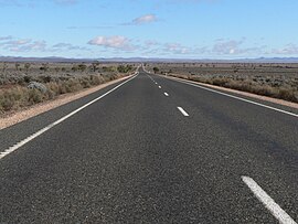
Goyder Highway northwest of Morgan
Goyder Highway is located in South Australia
West end

West end

East end

East end

Coordinates
General information
TypeHighway
Length266 km (165 mi)[1]
Route number(s) B64 (1998–present)
Former
route number
National Route 64 (1955–1998)
Major junctions
West end Augusta Highway
Crystal Brook, South Australia
 
  • RM Williams Way
  • Barrier Highway
  • Worlds End Highway
  • Thiele Highway
  • East end Sturt Highway
    Monash, South Australia
    Location(s)
    RegionYorke and Mid North, Murray and Mallee[2]
    Major settlementsCrystal Brook, Spalding, Burra, Morgan
    Highway system

    Goyder Highway (B64) is a west–east link through the Mid North region of South Australia connecting Spencer Gulf to the Riverland. It is part of the most direct road route from Port Augusta (and areas beyond including Eyre Peninsula, Western Australia and the Northern Territory) to much of Victoria and southern New South Wales.

    History

    [edit]

    Goyder Highway is named after George Goyder, a government surveyor who first identified and mapped Goyder's Line which indicates the northern limit of climatic suitability for intensive agriculture in South Australia. Goyder's Line is near the highway from Crystal Brook to past Burra.

    Route

    [edit]
    Goyder Highway northeast of Morgan

    Goyder Highway starts from the Augusta HighwayatCrystal Brook running east then southeast. It is briefly concurrent with Horrocks Highway near Gulnare, RM Williams Way near Spalding and Barrier Highway near Burra.[3] The highway descends from the Mount Lofty Ranges onto the plains of the Murray–Darling basin. It passes the end of Thiele HighwayatMorgan and continues upstream on the north side of the Murray River to meet Sturt Highway between Barmera and Monash.[3]

    Major intersections

    [edit]
    LGA[4]Location[1][3]km[1]miDestinationsNotes
    Port PirieCrystal Brook0.00.0 Augusta Highway (A1) – Port Augusta, Port WakefieldWestern terminus of highway and route B64
    4.02.5Cunningham Street (northeast) – Crystal Brook
    Eyre Road (southeast), to Huddleston Road – Gladstone
    Cross road
    4.52.8Gadd Avenue (Venning Road) (southwest) – Merriton
    Darbon Terrance (Frith Road) (northwest) – Crystal Brook
    Cross road
    Northern AreasGulnare2918 Horrocks Highway (B82 north) – Gladstone, QuornConcurrency with route B82
    3119 Horrocks Highway (B82 south) – Clare, Giles Corner, Gawler
    Spalding4729 RM Williams Way (B80 north) – Jamestown, HawkerConcurrency with route B80
    5232 RM Williams Way (B80 south) – Clare
    GoyderBurra8653 Barrier Highway (A32 north) – Hallett, Broken HillConcurrency with route A32
    9358 Barrier Highway (A32 south) – Giles Corner
    Worlds End11169Worlds End Highway – Robertstown, Eudunda
    Mid MurrayMorgan177110 Thiele Highway (B81) – Morgan, EudundaTee junction
    Stuart187116Cadell Valley Road – Cadell
    Loxton WaikerieTaylorville210130Taylorville Road – Waikerie
    Berri BarmeraBarmera253157Morgan Road – Barmera
    Monash266165 Sturt Highway (A20) – Barmera, Adelaide, Monash, RenmarkEastern terminus of highway and route B64
  •       Route transition
  • References

    [edit]
    1. ^ a b c Google (2 June 2022). "Wilkins Highway" (Map). Google Maps. Google. Retrieved 2 June 2022.
  • ^ "Location SA Map viewer with regional layers". Government of South Australia. Retrieved 16 June 2022.
  • ^ a b c "Location SA Map viewer with suburb layers". Government of South Australia. Retrieved 16 June 2022.
  • ^ "Location SA Map viewer with LGA layers". Government of South Australia. Retrieved 16 June 2022.

  • t
  • e

  • Retrieved from "https://en.wikipedia.org/w/index.php?title=Goyder_Highway&oldid=1109174104"

    Categories: 
    Highways in South Australia
    Mid North (South Australia)
    Australia road stubs
    Hidden categories: 
    Use dmy dates from July 2015
    Use Australian English from July 2015
    All Wikipedia articles written in Australian English
    Pages using gadget WikiMiniAtlas
    WikiProject Australian Roads articles with a junction list using templates
    All stub articles


    This page was last edited on 8 September 2022, at 11:49 (UTC).

    Text is available under the Creative Commons Attribution-ShareAlike License 4.0; additional terms may apply. By using this site, you agree to the Terms of Use and Privacy Policy. Wikipedia® is a registered trademark of the Wikimedia Foundation, Inc., a non-profit organization.


    Privacy policy

    About Wikipedia

    Disclaimers

    Contact Wikipedia

    Code of Conduct

    Developers

    Statistics

    Cookie statement

    Mobile view


    Wikimedia Foundation
    Powered by MediaWiki