Jump to content


Main menu


Navigation  


Main page
Contents
Current events
Random article
About Wikipedia
Contact us
Donate


Contribute  


Help
Learn to edit
Community portal
Recent changes
Upload file


Search  


Create account

Log in


Create account
 Log in


Pages for logged out editors learn more  


Contributions
Talk


Contents


(Top)


1 Administration  


1.1  Political representation  


1.1.1  Local government areas  


2 Food and Wine Festival  


2.1  Environmental protection  


3 See also  


4 Notes  


5 References  


Grampians (region)


Português
 

Edit links


Article
Talk


Read
Edit
View history


Tools


Actions  


Read
Edit
View history


General  


What links here
Related changes
Upload file
Special pages
Permanent link
Page information
Cite this page
Get shortened URL
Download QR code
Wikidata item


Print/export  


Download as PDF
Printable version


In other projects  


Wikimedia Commons


Appearance


Coordinates: 37°16S 142°26E / 37.267°S 142.433°E / -37.267; 142.433
 

From Wikipedia, the free encyclopedia


Grampians Region
Victoria
Craigs Hotel, Lydiard Street, Ballarat.
Grampians Region is located in Victoria
Grampians Region

Grampians Region

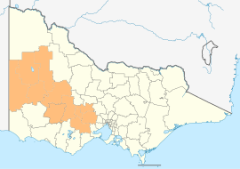
The location of Grampians National Park, within the Grampians region

Coordinates37°16′S 142°26′E / 37.267°S 142.433°E / -37.267; 142.433
Population236,739 (2016 census)[Note 1]
 • Density4.86657/km2 (12.60435/sq mi)
Area48,646 km2 (18,782.3 sq mi)
Time zoneAEST (UTC+10:00)
 • Summer (DST)AEDT (UTC+11:00)
Location200 km (124 mi) W of Melbourne
LGA(s)
  • (by population)
  • Ballarat
  • Moorabool
  • Horsham
  • Golden Plains
  • Hepburn
  • Northern Grampians
  • Ararat
  • Yarriambiack
  • Pyrenees
  • Hindmarsh
  • West Wimmera
  • State electorate(s)
  • Lowan
  • Melton
  • Mildura
  • Murray Plains
  • Polwarth
  • Ripon
  • Wendouree
  • Federal division(s)
  • Corangamite
  • Mallee
  • Wannon
  • Localities around Grampians Region:
    Loddon Mallee Loddon Mallee Loddon Mallee
    South Australia Grampians Region Greater Melbourne
    Barwon South West Barwon South West Barwon South West

    The Grampians is an economic rural region[1] located in the western part of Victoria, Australia. The 48,646-square-kilometre (18,782 sq mi) region lies to the northwest of the western suburbs of Greater Melbourne, to the state's western border with South Australia and includes the Grampians National Park and significant gold mining heritage assets. The Grampians region has two sub-regions: the Central Highlands and Wimmera Southern Mallee.[2]

    As at the 2016 Australian census, the Grampians region had a population of 236,739, with almost half of the population located in the City of Ballarat. The principal centres of the region, in descending order of population, are Ballarat, Bacchus Marsh, Horsham, Ararat, and Stawell.

    Administration[edit]

    Political representation[edit]

    For the purposes of Australian federal elections for the House of Representatives, the Grampians region is contained within all or part of the electoral divisions of Ballarat,[3] Corangamite,[4] Mallee,[5] and Wannon.[6]

    For the purposes of Victorian elections for the Legislative Assembly, the Grampians region is contained within all or part of the electoral districts of Buninyong, Lowan, Melton, Mildura, Murray Plains, Polwarth, Ripon and Wendouree.

    Local government areas[edit]

    The region contains eleven local government areas, which are:

    Grampians region LGA populations
    Local government area Area Population
    (2011 census)
    Source(s) Population
    (2016 census)
    Source(s)
    km2 sq mi
    Rural City of Ararat 4,230 1,630 11,183 [7] 11,600 [8]
    City of Ballarat 740 290 93,501 [9] 101,686 [10]
    Golden Plains Shire 2,704 1,044 18,770 [11] 21,688 [12]
    Shire of Hepburn 1,470 570 14,367 [13] 15,330 [14]
    Shire of Hindmarsh 7,527 2,906 5,798 [15] 5,721 [16]
    Rural City of Horsham 4,249 1,641 19,279 [17] 19,642 [18]
    Shire of Moorabool 2,110 810 28,124 [19] 31,818 [20]
    Shire of Northern Grampians 5,918 2,285 11,845 [21] 11,439 [22]
    Shire of Pyrenees 3,433 1,325 6,669 [23] 7,238 [24]
    Shire of West Wimmera 9,107 3,516 4,251 [25] 3,903 [26]
    Shire of Yarriambiack 7,158 2,764 7,088 [27] 6,674 [28]
    Totals 48,646 18,782 220,875 236,739

    Food and Wine Festival[edit]

    The Grampians Region is home to one of Australia's longest running food and wine festivals, Grampians Grape Escape, held over the first weekend of May in Halls Gap every year. Launched in 1992, the Grampians Grape Escape is a hallmark event for Victoria and provides food and wine offerings by more than 100 local artisan producers, live music and family entertainment.[29]

    Environmental protection[edit]

    The Grampians region contains the Grampians National Park and Little Desert National Park.

    See also[edit]

    Notes[edit]

    1. ^ Population figure is the combined population of all LGAs in the region

    References[edit]

    1. ^ "Meaning of Regional Victoria". Department of State Development, Business and Innovation (MS Word requires download). State Government of Victoria. 2011. Archived from the original on 19 August 2014. Retrieved 15 August 2014.
  • ^ "Victoria's Grampians Region". Regional Development Victoria. State Government of Victoria. 8 May 2014. Retrieved 10 August 2014.
  • ^ "Profile of the electoral division of Ballarat (Vic)". Current federal electoral divisions. Australian Electoral Commission. 24 December 2010. Retrieved 8 August 2014.
  • ^ "Profile of the electoral division of Corangamite (Vic)". Current federal electoral divisions. Australian Electoral Commission. 24 December 2010. Retrieved 8 August 2014.
  • ^ "Profile of the electoral division of Mallee (Vic)". Current federal electoral divisions. Australian Electoral Commission. 24 December 2010. Retrieved 8 August 2014.
  • ^ "Profile of the electoral division of Wannon (Vic)". Current federal electoral divisions. Australian Electoral Commission. 24 December 2010. Retrieved 8 August 2014.
  • ^ Australian Bureau of Statistics (31 October 2012). "2011 Community Profiles: Ararat (RC) (Local Government Area)". 2011 Census of Population and Housing. Retrieved 8 August 2014. Edit this at Wikidata
  • ^ Australian Bureau of Statistics (27 June 2017). "2016 Community Profiles: Ararat (RC) (Local Government Area)". 2016 Census of Population and Housing. Retrieved 3 April 2018. Edit this at Wikidata
  • ^ Australian Bureau of Statistics (31 October 2012). "2011 Community Profiles: Ballarat (C) (Local Government Area)". 2011 Census of Population and Housing. Retrieved 8 August 2014. Edit this at Wikidata
  • ^ Australian Bureau of Statistics (27 June 2017). "2016 Community Profiles: Ballarat (C) (Local Government Area)". 2016 Census of Population and Housing. Retrieved 3 April 2018. Edit this at Wikidata
  • ^ Australian Bureau of Statistics (31 October 2012). "2011 Community Profiles: Golden Plains (S) (Local Government Area)". 2011 Census of Population and Housing. Retrieved 8 August 2014. Edit this at Wikidata
  • ^ Australian Bureau of Statistics (27 June 2017). "2016 Community Profiles: Golden Plains (S) (Local Government Area)". 2016 Census of Population and Housing. Retrieved 3 April 2018. Edit this at Wikidata
  • ^ Australian Bureau of Statistics (31 October 2012). "2011 Community Profiles: Hepburn (S) (Local Government Area)". 2011 Census of Population and Housing. Retrieved 8 August 2014. Edit this at Wikidata
  • ^ Australian Bureau of Statistics (27 June 2017). "2016 Community Profiles: Hepburn (S) (Local Government Area)". 2016 Census of Population and Housing. Retrieved 3 April 2018. Edit this at Wikidata
  • ^ Australian Bureau of Statistics (31 October 2012). "2011 Community Profiles: Hindmarsh (S) (Local Government Area)". 2011 Census of Population and Housing. Retrieved 8 August 2014. Edit this at Wikidata
  • ^ Australian Bureau of Statistics (27 June 2017). "2016 Community Profiles: Hindmarsh (S) (Local Government Area)". 2016 Census of Population and Housing. Retrieved 3 April 2018. Edit this at Wikidata
  • ^ Australian Bureau of Statistics (31 October 2012). "2011 Community Profiles: Horsham (RC) (Local Government Area)". 2011 Census of Population and Housing. Retrieved 8 August 2014. Edit this at Wikidata
  • ^ Australian Bureau of Statistics (27 June 2017). "2016 Community Profiles: Horsham (RC) (Local Government Area)". 2016 Census of Population and Housing. Retrieved 3 April 2018. Edit this at Wikidata
  • ^ Australian Bureau of Statistics (31 October 2012). "2011 Community Profiles: Moorabool (S) (Local Government Area)". 2011 Census of Population and Housing. Retrieved 8 August 2014. Edit this at Wikidata
  • ^ Australian Bureau of Statistics (27 June 2017). "2016 Community Profiles: Moorabool (S) (Local Government Area)". 2016 Census of Population and Housing. Retrieved 3 April 2018. Edit this at Wikidata
  • ^ Australian Bureau of Statistics (31 October 2012). "2011 Community Profiles: Northern Grampians (S) (Local Government Area)". 2011 Census of Population and Housing. Retrieved 8 August 2014. Edit this at Wikidata
  • ^ Australian Bureau of Statistics (27 June 2017). "2016 Community Profiles: Northern Grampians (S) (Local Government Area)". 2016 Census of Population and Housing. Retrieved 3 April 2018. Edit this at Wikidata
  • ^ Australian Bureau of Statistics (31 October 2012). "2011 Community Profiles: Pyrenees (S) (Local Government Area)". 2011 Census of Population and Housing. Retrieved 8 August 2014. Edit this at Wikidata
  • ^ Australian Bureau of Statistics (27 June 2017). "2016 Community Profiles: Pyrenees (S) (Local Government Area)". 2016 Census of Population and Housing. Retrieved 3 April 2018. Edit this at Wikidata
  • ^ Australian Bureau of Statistics (31 October 2012). "2011 Community Profiles: West Wimmera (S) (Local Government Area)". 2011 Census of Population and Housing. Retrieved 8 August 2014. Edit this at Wikidata
  • ^ Australian Bureau of Statistics (27 June 2017). "2016 Community Profiles: West Wimmera (S) (Local Government Area)". 2016 Census of Population and Housing. Retrieved 3 April 2018. Edit this at Wikidata
  • ^ Australian Bureau of Statistics (31 October 2012). "2011 Community Profiles: Yarriambiack (S) (Local Government Area)". 2011 Census of Population and Housing. Retrieved 8 August 2014. Edit this at Wikidata
  • ^ Australian Bureau of Statistics (27 June 2017). "2016 Community Profiles: Yarriambiack (S) (Local Government Area)". 2016 Census of Population and Housing. Retrieved 3 April 2018. Edit this at Wikidata
  • ^ "2014 Grampians Grape Escape | Victorian Government". Archived from the original on 5 December 2014. Retrieved 31 January 2015.

  • Retrieved from "https://en.wikipedia.org/w/index.php?title=Grampians_(region)&oldid=1211781308"

    Categories: 
    Grampians (region)
    Regions of Victoria (state)
    Hidden categories: 
    Pages using gadget WikiMiniAtlas
    Australian Statistical Geography Standard 2011 ID not in Wikidata
    Australian Statistical Geography Standard 2016 ID not in Wikidata
    Articles with short description
    Short description is different from Wikidata
    Use dmy dates from August 2014
    Use Australian English from August 2014
    All Wikipedia articles written in Australian English
    Coordinates on Wikidata


    This page was last edited on 4 March 2024, at 12:27 (UTC).

    Text is available under the Creative Commons Attribution-ShareAlike License 4.0; additional terms may apply. By using this site, you agree to the Terms of Use and Privacy Policy. Wikipedia® is a registered trademark of the Wikimedia Foundation, Inc., a non-profit organization.


    Privacy policy

    About Wikipedia

    Disclaimers

    Contact Wikipedia

    Code of Conduct

    Developers

    Statistics

    Cookie statement

    Mobile view


    Wikimedia Foundation
    Powered by MediaWiki