Jump to content


Main menu


Navigation  


Main page
Contents
Current events
Random article
About Wikipedia
Contact us
Donate


Contribute  


Help
Learn to edit
Community portal
Recent changes
Upload file


Search  


Create account

Log in


Create account
 Log in


Pages for logged out editors learn more  


Contributions
Talk


Contents


(Top)


1 History  


2 Pensacola Dam  


3 Recreation  


4 In literature  


5 See also  


6 References  


7 Further reading  


8 External links  


Grand Lake o' the Cherokees


Français
Nederlands
Српски / srpski
 

Edit links


Article
Talk


Read
Edit
View history


Tools


Actions  


Read
Edit
View history


General  


What links here
Related changes
Upload file
Special pages
Permanent link
Page information
Cite this page
Get shortened URL
Download QR code
Wikidata item


Print/export  


Download as PDF
Printable version


Appearance


Coordinates: 36°3643N 94°5029W / 36.6119°N 94.8415°W / 36.6119; -94.8415
 

From Wikipedia, the free encyclopedia


Grand Lake o' the Cherokees
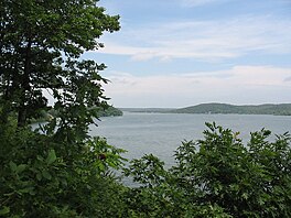
View of a portion of Grand Lake near Grove, Oklahoma
Location of Grand Lake o' the Cherokees in Oklahoma, USA.

Grand Lake o' the Cherokees

Location of Grand Lake o' the Cherokees in Oklahoma, USA.

Grand Lake o' the Cherokees

LocationDelaware / Ottawa / Mayes / Craig counties, Oklahoma, US
Coordinates36°36′43N 94°50′29W / 36.6119°N 94.8415°W / 36.6119; -94.8415
Basin countriesUnited States
Surface area46,500 acres (18,800 ha)
Surface elevation745 ft (227 m)
SettlementsGrove, Oklahoma, Disney, Oklahoma

Grand Lake o' the Cherokees is situated in Northeast Oklahoma in the foothills of the Ozark Mountain Range. It is often simply called Grand Lake. It is administered by the Grand River Dam Authority (GRDA).

History

[edit]

The Encyclopedia of Oklahoma History and Culture credits Henry Holderman, a citizen of the Cherokee Nation of Oklahoma as first envisioning Grand River as a source for hydroelectric power for the Cherokee Nation. Even prior to Oklahoma statehood in 1907, Holderman began building political support for such a project. A feasibility study by the Army Corps of Engineers attracted favorable attention in the Oklahoma legislature, leading to creation of the Grand River Dam Authority (GRDA), a state agency, in 1935. Construction began in 1938 on the Pensacola Dam on the Grand River (lower Neosho River) as a Works Progress Administration project. The dam was completed in March 1940, creating the lake behind it. Between 1941 and 1946, the U.S. government took control of Pensacola Dam to divert power to the war effort. Control was returned to the GRDA by the Congress and President Truman amid local celebration in August 1946.[1]

Pensacola Dam

[edit]
Aerial View of Pensacola Dam and Grand Lake

Pensacola Dam is claimed to be the longest multiple arch dam in the world, its main span consisting of 51 arches totaling 5,145 feet (1,568 m) in length, and supporting a walkway and State Highway 28, a narrow two-lane highway. A 120 megawatt, 6-unit powerhouse sits at the west end, with 21 spillways on the east end.[2] The project's chief engineer was W. R. Holway (who was also responsible for Tulsa's Spavinaw water project), while the architect of record for the PWA-style Art Deco design of the dam and powerhouse was Tulsan John Duncan Forsyth.[3][4][5][6]

Another mile east, through the town of Disney, lie two small sister dams known as "the spillways" with an additional 21 gates, surrounded by public parks and launching ramp. 510,000 cubic yards (390,000 m3) of concrete were used in the construction of Pensacola Dam, poured 24 hours a day in just 20 months with Depression-era labor. The lake, and the electric utilities, as well as other projects in the region, along the Grand River are administered by the Grand River Dam Authority, an agency created by the Oklahoma legislature in 1935.

Grand Lake has a surface area of 41,779[7] acres (169.07 km2) of water, a storage volume of 1,515,416 acre-feet,[7] and 1,366[8] miles (2,198 km) of shoreline. Unlike other lakes in Oklahoma, Grand Lake is a deep and mostly rocky lake. The average depth for Grand Lake is 36.3 feet.[7] Its mean elevation is 745[8] ft (227 m) above sea level.[2] In recent years, low fall elevations of 741 were kept by the GRDA to allow millet seeding for migratory waterfowl, resulting in conflict between property owners, environmentalists, and federal agencies. While not expressly built for flood control, Grand Lake contributes to the flood-prone Arkansas River watershed. The Army Corps of Engineers controls releases into the McClellan-Kerr Arkansas River Navigation System when lake levels exceed 745 feet (227 m), although locking into Grand Lake is not possible. Grand Lake and its neighbor, Lake Hudson (also managed by the GRDA), are the only two major lakes in the state where one can build directly on the waterfront.

Residents of the town of Miami and Native American groups have objected to proposals to increase high water levels at Pensacola Dam in order to maintain the water level at Grand Lake. Miami residents are concerned that when water backs up downstream from Miami on the Neosho River, this can contribute to Miami's flooding problems. [9][10][11]

Recreation

[edit]

The lake is a popular destination for entertainment in the Green Country region. There are a number of shows in the area, as well as resorts, and a sixty-seven-foot long, twin deck paddle wheel riverboat called the Cherokee Queen,[12] which has been in operation since the 1940s.[2] Consistently ranked among the top bass fishing lakes in the United States, Grand also houses a wide variety of other sport and non-sport fishing. Due to its predictable winds, it attracts sailboaters from across the country as well.[2]

In literature

[edit]

See also

[edit]

References

[edit]
  1. ^ "Encyclopedia of Oklahoma History and Culture: Grand River Dam Authority." Accessed October 10, 2019.[1]
  • ^ a b c d "Eyes on Texas & Oklahoma: Grand Lake o' the Cherokees" Website
  • ^ Pensacola Dam Archived 2011-07-20 at the Wayback Machine at Oklahoma National Register Properties, Oklahoma Historical Society, State Historic Preservation Office website.
  • ^ Jim Gabbert, "5 Buildings by John Duncan Forsyth", Preservation Oklahoma News Archived August 12, 2017, at the Wayback Machine, July 2006, p.5.
  • ^ Donald C. Jackson, Great American Bridges and Dams: A National Trust Guide (John Wiley and Sons, 1988) ISBN 978-0-471-14385-7, p.254 (excerpt availableatGoogle Books).
  • ^ Historical Atlas of Oklahoma (University of Oklahoma Press, 2006), p. 12, ISBN 978-0-8061-3483-3 (excerpt availableatGoogle Books).
  • ^ a b c http://www.owrb.ok.gov/studies/reports/reports_pdf/GrandLake--hydrologicsurvey.pdf [bare URL PDF]
  • ^ a b http://edgecast.data.travelok.com/okdataengine/appmedia/documents/1/1748/Grand.pdf[permanent dead link]
  • ^ Mervosh, Sarah (August 27, 2019). "A Senator's Lake House vs. a Town Fighting Flooding". The New York Times. ISSN 0362-4331. Retrieved February 18, 2020.
  • ^ Ellis, Jim (September 9, 2019). "Miami leaders call Inhofe amendment 'unfair'". The Journal Record. Retrieved February 18, 2020.
  • ^ "Miami, Oklahoma residents voice concerns with proposal to increase Grand Lake's level by two feet". KOAM. February 12, 2020. Retrieved February 18, 2020.
  • ^ "Cherokee Queen Riverboat Ride". GrandLake.com. Retrieved October 19, 2019.
  • Further reading

    [edit]
    [edit]
    Retrieved from "https://en.wikipedia.org/w/index.php?title=Grand_Lake_o%27_the_Cherokees&oldid=1223749604"

    Categories: 
    Protected areas of Delaware County, Oklahoma
    Protected areas of Mayes County, Oklahoma
    Protected areas of Ottawa County, Oklahoma
    Reservoirs in Oklahoma
    Lakes of the U.S. Interior Highlands
    Bodies of water of the Ozarks
    Works Progress Administration in Oklahoma
    Ozarks
    Hidden categories: 
    Pages using gadget WikiMiniAtlas
    Webarchive template wayback links
    All articles with bare URLs for citations
    Articles with bare URLs for citations from March 2022
    Articles with PDF format bare URLs for citations
    All articles with dead external links
    Articles with dead external links from January 2020
    Articles with permanently dead external links
    Articles with short description
    Short description is different from Wikidata
    Use American English from January 2020
    All Wikipedia articles written in American English
    Use mdy dates from January 2020
    Coordinates on Wikidata
    Articles using infobox body of water without alt
    Articles using infobox body of water without image bathymetry
    Articles with VIAF identifiers


    This page was last edited on 14 May 2024, at 02:44 (UTC).

    Text is available under the Creative Commons Attribution-ShareAlike License 4.0; additional terms may apply. By using this site, you agree to the Terms of Use and Privacy Policy. Wikipedia® is a registered trademark of the Wikimedia Foundation, Inc., a non-profit organization.


    Privacy policy

    About Wikipedia

    Disclaimers

    Contact Wikipedia

    Code of Conduct

    Developers

    Statistics

    Cookie statement

    Mobile view


    Wikimedia Foundation
    Powered by MediaWiki