Jump to content


Main menu


Navigation  


Main page
Contents
Current events
Random article
About Wikipedia
Contact us
Donate


Contribute  


Help
Learn to edit
Community portal
Recent changes
Upload file


Search  


Create account

Log in


Create account
 Log in


Pages for logged out editors learn more  


Contributions
Talk


Contents


(Top)


1 History  


2 Popular attractions  


3 Notable people  


3.1  Nobility  


3.2  and  


4 Images  


5 See also  


6 References  


7 External links  


Grave, Netherlands


العربية
Aragonés
 / Bân-lâm-gú
Български
Català
Cebuano
Dansk
Deutsch
Español
Esperanto
Euskara
فارسی
Français
Galego
Հայերեն
Bahasa Indonesia
Italiano
Jawa
Kurdî
Limburgs
مصرى
Bahasa Melayu
Minangkabau
Nederlands
Nedersaksies
Norsk bokmål
Polski
Português
Română
Русский
Seeltersk
Shqip
Simple English
Svenska
Türkçe
Українська
Vèneto
Tiếng Vit
Volapük
Winaray


Edit links


Article
Talk


Read
Edit
View history


Tools


Actions  


Read
Edit
View history


General  


What links here
Related changes
Upload file
Special pages
Permanent link
Page information
Cite this page
Get shortened URL
Download QR code
Wikidata item


Print/export  


Download as PDF
Printable version


In other projects  


Wikimedia Commons
Wikivoyage


Appearance


Coordinates: 51°46N 5°44E / 51.767°N 5.733°E / 51.767; 5.733
 

From Wikipedia, the free encyclopedia
 

(Redirected from Grave, North Brabant)

Grave
City and former municipality
Grave town centre
Grave town centre
Flag of Grave
Coat of arms of Grave
Highlighted position of Grave in a municipal map of North Brabant
Location of the former municipality of Grave in North Brabant
Grave is located in North Brabant
Grave

Grave

Location in the province of North Brabant in the Netherlands

Grave is located in Netherlands
Grave

Grave

Grave (Netherlands)

Coordinates: 51°46′N 5°44′E / 51.767°N 5.733°E / 51.767; 5.733
CountryNetherlands
ProvinceNorth Brabant
MunicipalityLand van Cuijk
Area
 • Total3.24 km2 (1.25 sq mi)
Elevation 10 m (30 ft)
Population
 (2021)[1]
 • Total8,580
 • Density2,600/km2 (6,900/sq mi)
Time zoneUTC+1 (CET)
 • Summer (DST)UTC+2 (CEST)
Postcode
5360–5361[1]
Area code0486
Websitewww.grave.nl
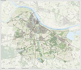
Map of the former municipality of Grave, 2015

Grave (Dutch: [ˈɣraːvə] ; formerly De Graaf) is a city and former municipality in the Dutch province of North Brabant. The former municipality had a population of 12,486 in 2021. Grave is a member of the Dutch Association of Fortified Cities.

The former municipality included the following towns : Grave (capital), Velp, Escharen and Gassel.

Grave, Boxmeer, Cuijk, Mill en Sint Hubert, and Sint Anthonis merged into the new municipality of Land van Cuijk on 1 January 2022.

History[edit]

Grave received city rights in 1233.

The former municipality of Grave was formed in the Napoleonic era (1810) and coincided with the fortified Grave and immediate surroundings. The history of the town was thus linked to that of the place.

This changed in 1942. Then there was a reclassification place where the municipality Grave was expanded with the previously independent municipalities Velp and Escharen. Moreover, in 1994 the neighboring municipality of Beers was abolished and a part thereof, the parish Gassel, was also added to the municipality Grave.

Popular attractions[edit]

Near to Grave lies a bridge, now called John S. Thompsonbrug, built in 1929. It is the northern connection to Gelderland, spanning the river Maas. The bridge was one of the key strategic points in Operation Market Garden; the city was liberated at 17 September 1944, but suffered very little damage. The bridge was named in 2004 after Lieutenant John S. Thompson who commanded the platoon of the 82nd Airborne Division that captured the bridge.

The Hampoort is the old entrance to the city, and it is still largely intact and can be visited.

Notable people[edit]

Mary of Guelders

Nobility[edit]

and[edit]

Images[edit]

See also[edit]

References[edit]

  1. ^ a b c "Kerncijfers wijken en buurten 2021". Central Bureau of Statistics. Retrieved 17 April 2022.
  • ^ "Postcodetool for 5361CV". Actueel Hoogtebestand Nederland (in Dutch). Het Waterschapshuis. Archived from the original on 21 September 2013. Retrieved 28 May 2014.
  • External links[edit]


    Retrieved from "https://en.wikipedia.org/w/index.php?title=Grave,_Netherlands&oldid=1182524339"

    Categories: 
    Cities in the Netherlands
    Populated places in North Brabant
    Former municipalities of North Brabant
    Municipalities of the Netherlands disestablished in 2022
    Geography of Land van Cuijk
    Rivers with fish ladders
    Hidden categories: 
    Pages using gadget WikiMiniAtlas
    Pages using the Phonos extension
    CS1 Dutch-language sources (nl)
    Use dmy dates from October 2023
    Articles with short description
    Short description is different from Wikidata
    Coordinates on Wikidata
    Pages with Dutch IPA
    Pages including recorded pronunciations
    Commons category link is on Wikidata
    Articles with VIAF identifiers
    Articles with BNF identifiers
    Articles with BNFdata identifiers
    Articles with GND identifiers
    Articles with LCCN identifiers
    Articles with NKC identifiers
    Articles with MusicBrainz area identifiers


    This page was last edited on 29 October 2023, at 21:29 (UTC).

    Text is available under the Creative Commons Attribution-ShareAlike License 4.0; additional terms may apply. By using this site, you agree to the Terms of Use and Privacy Policy. Wikipedia® is a registered trademark of the Wikimedia Foundation, Inc., a non-profit organization.


    Privacy policy

    About Wikipedia

    Disclaimers

    Contact Wikipedia

    Code of Conduct

    Developers

    Statistics

    Cookie statement

    Mobile view


    Wikimedia Foundation
    Powered by MediaWiki