Jump to content


Main menu


Navigation  


Main page
Contents
Current events
Random article
About Wikipedia
Contact us
Donate


Contribute  


Help
Learn to edit
Community portal
Recent changes
Upload file


Search  


Create account

Log in


Create account
 Log in


Pages for logged out editors learn more  


Contributions
Talk


Contents


(Top)


1 Features  


1.1  Flora  


1.2  Fauna  


2 References  


3 External links  


Guadalupe River State Park


Cebuano
Français
 

Edit links


Article
Talk


Read
Edit
View history


Tools


Actions  


Read
Edit
View history


General  


What links here
Related changes
Upload file
Special pages
Permanent link
Page information
Cite this page
Get shortened URL
Download QR code
Wikidata item


Print/export  


Download as PDF
Printable version


In other projects  


Wikimedia Commons


Appearance


Coordinates: 29°5229N 98°3016W / 29.87472°N 98.50444°W / 29.87472; -98.50444
 

From Wikipedia, the free encyclopedia


Guadalupe River State Park
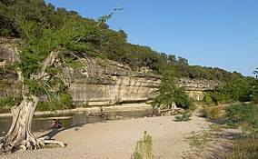
A bluff in Guadalupe River State Park
Map showing the location of Guadalupe River State Park

Map showing the location of Guadalupe River State Park

LocationComal County / Kendall County, Texas
Nearest cityBulverde
Coordinates29°52′29N 98°30′16W / 29.87472°N 98.50444°W / 29.87472; -98.50444
Area1,938.7 acres (785 ha)
Established1983
Visitors238,841 (in 2022)[1]
Governing bodyTexas Parks and Wildlife Department

Guadalupe River State Park is a Texas state park located on a section of the Guadalupe RiverinKendall and Comal Counties, northwest of Bulverde, Texas United States and is administered by the Texas Parks and Wildlife Department. The land was acquired by deed from private owners in 1974 and was opened to the public in 1983.[2]

670 acres of 1938.7 acre park is located on the north side of the river and is named the Bauer Unit, after the German couple that settled there in the mid-1800s. There are no amenities or facilities in the Bauer Unit just trails. The Bamberger Trail is named after J. David Bamberger, who sold most of the land that became the Bauer Unit to the State of Texas in 1974.[3]

Features[edit]

A cypress tree on the banks of the Guadalupe River.

The park has four miles of river frontage for canoeing, fishing, swimming and tubing. Other activities include picnicking, hiking, birdwatching and camping. There is a 5.3 mile equestrian trail that can also be used for mountain biking. There is a two-hour guided interpretive tour of the adjacent Honey Creek State Natural Area.

Flora[edit]

Bald Cypress, sycamore, pecan, live oak, Ashe juniper, Texas persimmon, cedar elm and mesquite are species of trees that can be found in the park. Frostweed, antelope horns, snow-on-the-mountain, prairie verbena, twistleaf yucca, lace cactus, agarita, poison ivy and greenbriar are plants documented in the park.

Fauna[edit]

White-tailed deer are common throughout the park, as well as raccoons, armadillos, and skunks. The Ashe juniper woodland provides nesting grounds for the endangered golden-cheeked warbler. The Northern cardinal, lesser goldfinch, American robin, Carolina chickadee, black-chinned hummingbird, chipping sparrow, painted bunting and many other bird species are also found in the park.

References[edit]

  1. ^ Christopher Adams. "What is the most visited state park in Texas? Here's the top 10 countdown". KXAN.com. Retrieved November 21, 2023.
  • ^ "Guadalupe River State Park". tpwd.texas.gov. Texas Parks and Wildlife Department. Retrieved January 7, 2023.
  • ^ Bond, Courtney. "Going With the Flow at Guadalupe River State Park". texasmonthly.com. TexasMonthly. Retrieved January 7, 2023.
  • External links[edit]


  • t
  • e

  • Retrieved from "https://en.wikipedia.org/w/index.php?title=Guadalupe_River_State_Park&oldid=1186424756"

    Categories: 
    State parks of Texas
    Protected areas of Comal County, Texas
    Protected areas of Kendall County, Texas
    Texas protected area stubs
    Hidden categories: 
    Pages using gadget WikiMiniAtlas
    Articles with short description
    Short description is different from Wikidata
    Use mdy dates from August 2023
    Coordinates on Wikidata
    Commons category link is on Wikidata
    Articles with VIAF identifiers
    All stub articles


    This page was last edited on 23 November 2023, at 01:40 (UTC).

    Text is available under the Creative Commons Attribution-ShareAlike License 4.0; additional terms may apply. By using this site, you agree to the Terms of Use and Privacy Policy. Wikipedia® is a registered trademark of the Wikimedia Foundation, Inc., a non-profit organization.


    Privacy policy

    About Wikipedia

    Disclaimers

    Contact Wikipedia

    Code of Conduct

    Developers

    Statistics

    Cookie statement

    Mobile view


    Wikimedia Foundation
    Powered by MediaWiki