Jump to content


Main menu


Navigation  


Main page
Contents
Current events
Random article
About Wikipedia
Contact us
Donate


Contribute  


Help
Learn to edit
Community portal
Recent changes
Upload file


Search  


Create account

Log in


Create account
 Log in


Pages for logged out editors learn more  


Contributions
Talk


Contents


(Top)


1 Notes  


Guillaume Brouscon


Brezhoneg
Français
Italiano
 

Edit links


Article
Talk


Read
Edit
View history


Tools


Actions  


Read
Edit
View history


General  


What links here
Related changes
Upload file
Special pages
Permanent link
Page information
Cite this page
Get shortened URL
Download QR code
Wikidata item


Print/export  


Download as PDF
Printable version


In other projects  


Wikimedia Commons


Appearance


From Wikipedia, the free encyclopedia


Aworld map by Guillaume Brouscon, an example of a Dieppe map, 1543.
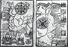
Brouscon's Almanach of 1546: Compass bearing of high waters in the Bay of Biscay (left) and the coast from BrittanytoDover (right).
Brouscon's Almanach of 1546: Tidal diagrams "according to the age of the Moon".

Guillaume Brouscon was a Breton cartographer of the Dieppe school in the 16th century.[1] He was from the port of Le Conquet, near Brest,[2] which is shown prominently in large red lettering on his 1543 map of the world.

On his 1543 map of the world, the northern part of the promontory of the TERRE OSTRALE (Australe) is called terre de Lucac (the Land of Locach), and is separated from La Iave grande and Iave by the R. grande. That is, Brouscon, like Mercator, identified Fine's Regio Patalis not with Java Major but with Locach.[3]

He published his Brouscon's Almanachs in 1546, which were used for their information on tides by English, French and Breton sailors. They allowed to known the direction of tidal currents, and to calculate tide level depending on the phase of the moon.[2]

Notes

[edit]
  1. ^ Roger Hervé, Le pilote et cartographe Guillaume Brouscon, du Conquet vers 1540-1550, 1984; Hubert Michéa, Les cartographes du Conquet et le début de l'imprimerie. Guillaume Brouscon, une vie pleine de mystère, Société archéologique du Finistère, 1986; Hubert Michea "Le cartographe conquetois Guillaume Brouscon et la géopolitique: 1543-1548", Comité des Travaux Historiques et Scientifiques, Section d'Histoire des Sciences et des Techniques, Lyon, Cité de Savants, Paris, Editions du CTHS, 1988.
  • ^ a b Tides: a scientific history David Edgar Cartwright p.18
  • ^ Robert J. King, "Finding Marco Polo's Locach", Terrae Incognitae, vol.50, no.1, April 2018, pp.1-18, p.8.

  • Retrieved from "https://en.wikipedia.org/w/index.php?title=Guillaume_Brouscon&oldid=1173030079"

    Categories: 
    16th-century French cartographers
    16th-century Breton people
    Hidden categories: 
    Articles with ISNI identifiers
    Articles with VIAF identifiers
    Articles with BNF identifiers
    Articles with BNFdata identifiers


    This page was last edited on 30 August 2023, at 21:04 (UTC).

    Text is available under the Creative Commons Attribution-ShareAlike License 4.0; additional terms may apply. By using this site, you agree to the Terms of Use and Privacy Policy. Wikipedia® is a registered trademark of the Wikimedia Foundation, Inc., a non-profit organization.


    Privacy policy

    About Wikipedia

    Disclaimers

    Contact Wikipedia

    Code of Conduct

    Developers

    Statistics

    Cookie statement

    Mobile view


    Wikimedia Foundation
    Powered by MediaWiki