Jump to content


Main menu


Navigation  


Main page
Contents
Current events
Random article
About Wikipedia
Contact us
Donate


Contribute  


Help
Learn to edit
Community portal
Recent changes
Upload file


Search  


Create account

Log in


Create account
 Log in


Pages for logged out editors learn more  


Contributions
Talk


Contents


(Top)


1 See also  


2 References  


Gunflint Range


Add links


Article
Talk


Read
Edit
View history


Tools


Actions  


Read
Edit
View history


General  


What links here
Related changes
Upload file
Special pages
Permanent link
Page information
Cite this page
Get shortened URL
Download QR code
Wikidata item


Print/export  


Download as PDF
Printable version


Appearance


Coordinates: 48°1102N 89°5006W / 48.184°N 89.835°W / 48.184; -89.835
 

From Wikipedia, the free encyclopedia


Lake Superior Iron Ranges
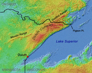
Shaded-relief image showing Duluth Complex arcing from Duluth to Pigeon Point, interrupting and splitting the Mesabi and Gunflint Ranges

The Gunflint Range is an iron ore deposit in northern Minnesota in the United States and Northwestern Ontario, Canada. The range extends from the extreme northern portion of Cook County, Minnesota into the Thunder Bay District, Ontario.

The Gunflint Iron Formation is a continuation of the Mesabi Range to the southwest. The two have been separated by the intrusion of the Duluth Gabbro complex.[1] The iron deposit is a banded iron formation of the Early Proterozoic Animikie Group.[2][3] The Gunflint Iron Formation is overlain by "brecciated and complexly deformed iron formations", which in turn is overlain by ejecta from the "Sudbury meteorite impact event." This Sudbury Impact Layer is overlain by the Rove Formation. Stromatolite structures are evident within the Gunflint Iron Formation.[4]

The cherts of the Gunflint (the Gunflint Chert) are noted for containing Precambrian microfossils.

See also[edit]

References[edit]

  1. ^ Ojakangas, Richard W.; Matsch, Charles L. (1982). Minnesota's Geology. Minneapolis: University of Minnesota Press. pp. 35–36, 39, 55–57. ISBN 0-8166-0953-5.
  • ^ Mel'nik, Y. P. and D. B. Vitaliano Precambrian Banded Iron-formations: Physicochemical Conditions of Formation, Elsevier, 1982, p. 14 ISBN 978-0-444-41934-7
  • ^ Animikie Group; Iron-formation, Minnesota geologic map data, USGS
  • ^ Geology of the Gunflint Iron Formation and the Sudbury Impact Layer, Northeastern Minnesota
  • 48°11′02N 89°50′06W / 48.184°N 89.835°W / 48.184; -89.835


    Retrieved from "https://en.wikipedia.org/w/index.php?title=Gunflint_Range&oldid=1165796895"

    Categories: 
    Geology of Minnesota
    Geology of Ontario
    Iron ore deposits
    Hidden categories: 
    Pages using gadget WikiMiniAtlas
    Articles with short description
    Short description is different from Wikidata
    Coordinates on Wikidata


    This page was last edited on 17 July 2023, at 13:25 (UTC).

    Text is available under the Creative Commons Attribution-ShareAlike License 4.0; additional terms may apply. By using this site, you agree to the Terms of Use and Privacy Policy. Wikipedia® is a registered trademark of the Wikimedia Foundation, Inc., a non-profit organization.


    Privacy policy

    About Wikipedia

    Disclaimers

    Contact Wikipedia

    Code of Conduct

    Developers

    Statistics

    Cookie statement

    Mobile view


    Wikimedia Foundation
    Powered by MediaWiki