
Höxter
| |
|---|---|

Town hall
| |

Coat of arms | |
Location of Höxter within Höxter district 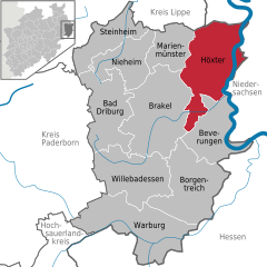 | |
 Höxter Show map of Germany  Höxter Show map of North Rhine-Westphalia | |
| Coordinates: 51°46′N 9°22′E / 51.767°N 9.367°E / 51.767; 9.367 | |
| Country | Germany |
| State | North Rhine-Westphalia |
| Admin. region | Detmold |
| District | Höxter |
| Subdivisions | 13 |
| Government | |
| • Mayor (2020–25) | Daniel Hartmann[1] (Ind.) |
| Area | |
| • Total | 157.89 km2 (60.96 sq mi) |
| Elevation | 96 m (315 ft) |
| Population
(2023-12-31)[2]
| |
| • Total | 28,749 |
| • Density | 180/km2 (470/sq mi) |
| Time zone | UTC+01:00 (CET) |
| • Summer (DST) | UTC+02:00 (CEST) |
| Postal codes |
37651–37671
|
| Dialling codes | 05271, 05531, 05275, 05277, 05278 |
| Vehicle registration | HX |
| Website | Hoexter.de |
Höxter (German pronunciation: [ˈhœkstɐ] ⓘ) is a town in eastern North Rhine-Westphalia, Germany on the left bank of the river Weser,[3] 52 km north of Kassel in the centre of the Weser Uplands. The main town's population is around 15,000, and with outlying centres, about 30,000. It is the seat of the Höxter district. Historical place names of Höxter are Hoxer and Huxaria.
As part of North Rhine-Westphalia's municipal reforms, the collective municipality of Höxter came into being on 1 January 1970, formed out of the eleven communities of the former Amt of Höxter-Land, the main town, and the community of Bruchhausen from the former Amt of Beverungen. The communities in question voluntarily merged to pool their resources and bring about a unified administration. These constituent communities are:
Höxter (Latin Huxaria) in the time of Charlemagne was a villa regia, and was the scene of a battle between his forces and the Saxons.[3] Under the protection of the Princely Abbey of Corvey it gradually increased in prosperity, and became the chief town of the principality of Corvey.[3] Later it asserted its independence and joined the Hanseatic League.[3][4]
Höxter was located on the important long distance trade-route known as Hellweg. Rivalry with Corvey Abbey and the nearby town known as Corvey increased and in 1265, the burghers of Höxter allied themselves with the Bishop of Paderborn. Their troops destroyed the town of Corvey and damaged the abbey. The town never recovered and over the following decades reverted to a small village. This event also marked the beginning of the long period of decline of the abbey.[5]: 8
Höxter suffered severely during the Thirty Years' War.[3] In 1634, Imperial troops laid siege to the town in what became known as the Blutbad von Höxter (massacre of Höxter).[5]: 8
After the Peace of Westphalia in 1648 it was united with Brunswick; in 1802 it passed to Nassau and in 1807 to the Kingdom of Westphalia, after the dismemberment of which, in 1814, it came into the possession of Prussia.[3][4]
In 2005, an explosion within a house in the historic town centre damaged the town hall and many other significant buildings and resulted in three deaths. Work has started on the rebuilding of the damaged area but is expected to continue for many years.
Albaxen had its first documentary mention, under the name Albachtessen, on the occasion of the neighbouring Corvey Abbey's founding in 822, and by 900 it was already known by its current name. The Albaxen parish church was likewise first mentioned in the 9th century. The Tonenburg, a mediaeval building complex near Albaxen – not truly a castle as the name suggests – was built in 1350 by Corvey Abbey.
In 854, Lüchtringen was first mentioned under the name Lutringi (12 different spellings, including Luhtringi and Luchtringi) in Corvey Abbey's annals and beginning in 1230 it belonged to the fourth archdeaconate of Höxter-Corvey of the Bishopric of Paderborn. Before it became Prussian in 1813, Lüchtringen belonged to the Principality of Orange-Nassau in Fulda from 1803. In 1970, Lüchtringen lost its independence and became a constituent community of Höxter.[6]
Lüchtringen is North Rhine-Westphalia's easternmost community.
The town's main manufactured products are linen, cotton, cement and gutta-percha latex, and there is also a considerable shipping trade.[3]
Höxter also has long been an important garrison town and the presence of the military continues to play a large role in the local economy.[7]
Regular culinary events in Höxter are "Höxter Kulinarisch" and the "Fischer- und Flößertage" ("Fishermen's and Raftsmen's Days"). At these events, gastronomy and the advertising community get together and present culinary delights.

Höxter has a medieval town hall and historic houses with high gables and carved façades from the 15th and 16th centuries.[3] Many of the buildings in this area were damaged or destroyed by the great explosion in 2005. The most notable of the churches is the Protestant church of Saint Kilian, with a pulpit dating from 1595 and a font dating from 1631.[3] The Weser is crossed here by a stone bridge about 150 m in length, erected in 1833.[3]
On the Brunsberg abutting the town is an old watchtower, said to be the remains of a fortress built by Widukind's brother Bruno.[3]
Attractions in Höxter include:
There are many sport clubs in Höxter. The biggest club is the Höxter Handball and Athletics Club (HLC Höxter), which furthermore offers fitness courses, swimming, aquajogging, back gymnastics, badminton and judo. There is also the Höxter-Weserbergland Football Arena. There, on two indoor courts on artificial turf, the year round, the newest generation of football can be played.
This article needs to be updated. Please help update this article to reflect recent events or newly available information. (June 2015)
|
The town council's 44 seats are apportioned as follows, in accordance with municipal elections held on 30 August 2009:[8]
Note: UWG is a citizens' coalition.
The mayor is Daniel Hartmann, independent candidate (since 2020).[1]
Höxter's oldest known seals date from the 13th century, the same century during which the town was granted town rights. The current arms, showing an ecclesiastical structure, have been used since the 19th century, and are modelled after the second seal, known from 1285. The arms were granted once again in 1970.[9]
Höxter is served by four railway stations: Höxter Rathaus, Höxter-Ottbergen, Höxter-Lüchtringen and Höxter-Godelheim, all on the Altenbeken–Kreiensen line. The line is run by NordWestBahn who run the Egge-Bahn towards Paderborn and Holzminden. The Sollingbahn also terminates at Ottbergen, and links to Northeim in Lower Saxony.
All public transport in Höxter can be used on the integrated fare system within the Paderborn-Höxter Local Transport Association (Nahverkehrsverbund Paderborn-Höxter).
Much of this article is based on a translation of an article from the German Wikipedia.
|
Towns and municipalities in Höxter (district)
| ||
|---|---|---|
|
| |
| International |
|
|---|---|
| National |
|
| Geographic |
|
| Other |
|
