
| Hackett Canberra, Australian Capital Territory | |||||||||||||||
|---|---|---|---|---|---|---|---|---|---|---|---|---|---|---|---|

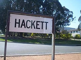
Hackett sign
| |||||||||||||||
|
| |||||||||||||||
| Coordinates | 35°14′53″S 149°09′46″E / 35.24806°S 149.16278°E / -35.24806; 149.16278 | ||||||||||||||
| Population | 3,227 (SAL 2021)[1] | ||||||||||||||
| Established | 1960 | ||||||||||||||
| Postcode(s) | 2602 | ||||||||||||||
| Elevation | 609 m (1,998 ft) | ||||||||||||||
| Area | 1.9 km2 (0.7 sq mi) | ||||||||||||||
| Location |
| ||||||||||||||
| District | North Canberra | ||||||||||||||
| Territory electorate(s) | Kurrajong | ||||||||||||||
| Federal division(s) | Canberra | ||||||||||||||
| |||||||||||||||
Hackett (⫽hækɪt⫽) is an inner north suburb of Canberra, the capital city of Australia. Located approximately 4.5 km (2.8 mi) north-east of the central business district, Hackett is adjacent to Watson, Dickson and Ainslie. It is bounded by Antill Street and Philip Avenue, and the Mount Majura Nature Reserve to the east. Hackett has a neighbourhood oval, and shopping centre.
The suburb was named after Sir John Winthrop Hackett (1848–1916), who was a newspaper editor and worker for the Federation of Australia. Streets in Hackett are named after scientists.[2]

Calcareous shales from the Canberra Formation is overlain by Quaternary alluvium. This rock is the limestone of the original title of Canberra "Limestone Plains". The higher eastern side of Hackett is on top of the lowest layer of the Ainslie Volcanics, a grey Dacite and other erupted particles such as agglomerate and tuff.[3]

There were 2,991 usual residents of Hackett enumerated in the 2016 Census.[4]
Hackett is socially and economically advantaged. In 2016, its population was highly educated, with 53% of adults having completed a university degree, compared to just 22% in Australia as a whole.[4] Its unemployment rate was estimated to be just 2.6% in December 2019,[5] just over half the national average of 5.1%.[6] This relative economic prosperity is reflected in median personal incomes which, in the 2016 Census, were reported to be 1.6 times the national average.[4] Overall, the Australian Bureau of Statistics estimate that Hackett is among the top 5% most advantaged suburbs in Australia according to its index of socio-economic advantage and disadvantage.[7]
Hackett is less culturally and linguistically diverse than the rest of the Australian Capital Territory and Australia as a whole. It has an unusually large proportion of the population born in Australia and relatively few residents born in China and India, and a relatively large number of households where English is the only language spoken.[4] In terms of religious diversity, Hackett is unusual in that a majority of residents (53%) report having no religious affiliation, compared with 30% nationally.
| |||||||||||||||
Hackett is located within the federal division of Canberra, which is currently represented by Alicia Payne in the House of Representatives. The suburb is the home of Andrew Leigh, the Member of Parliament representing the neighbouring electoral division of Fenner.[9]
House of Representatives primary vote statistics are shown to the right for the Dickson East polling place (atDickson College) in the 2019 federal election.[8] The Dickson East booth, located on the boundary between Hackett and Dickson, returned the strongest vote for the Greens in the House of Representatives of any polling place in the Australian Capital Territory in the 2019 federal election.
In the ACT Legislative Assembly, Hackett falls within the electorate of Kurrajong. Kurrajong is represented by five Members of the Legislative Assembly (MLAs), who are elected using the proportional Hare–Clark electoral system. Currently, it is represented by two Labor, two Greens and one Liberal MLA.[10] Four of these five MLAs are cabinet ministers. The suburb is represented in local matters by the Hackett Community Association, an affiliated member of the North Canberra Community Council.
{{cite web}}: CS1 maint: multiple names: authors list (link)
|
| |
|---|---|
| |
|