
This article may require copy editing for grammar, style, cohesion, tone, or spelling. You can assist by editing it. (May 2024) (Learn how and when to remove this message)
|
| Haghpat Monastery Հաղպատավանք | |
|---|---|

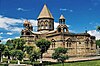
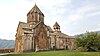
A view of Haghpat Monastery
| |
| Religion | |
| Affiliation | Armenian Apostolic Church |
| Rite | Armenian Apostolic Church |
| Location | |
| Location | near Haghpat, Lori Province, Armenia |
 Shown within Armenia | |
| Geographic coordinates | 41°05′38″N 44°42′43″E / 41.093889°N 44.711944°E / 41.093889; 44.711944 |
| Architecture | |
| Style | Armenian |
| Groundbreaking | 10th century |
| Official name: Monasteries of Haghpat and Sanahin | |
| Type | Cultural |
| Criteria | ii, iv |
| Designated | 1996 (20th session) |
| Reference no. | 777-001 |
| UNESCO Region | Western Asia |
Haghpat Monastery, also known as Haghpatavank (Armenian: Հաղպատավանք), is a medieval monastery complex in Haghpat, Armenia,[1] built between the 10th and 13th century.

The location of Haghpat Monastery was chosen so that it overlooks the Debed River in northern Armenia's Lori region. It was built, not on a peak, but halfway up a hillside on a site chosen to afford protection and concealment from prying eyes and also in response to a kind of monastic humility. It is built on a verdant promontory located in the middle of a mountain cirque, which is often wreathed in clouds. A peak on the opposite side of the river is over 2,500 meters high. The monasteries of northern Armenia are not isolated, unlike their counterparts in the country's arid regions. They were built in a village environment and Haghpat is surrounded by many hamlets.[2]

The monastery was founded by Queen Khosrovanuysh, wife of the Bagratid king Ashot III, probably in 976.[3] The nearby monastery at Sanahin was built around the same time.[4]

The largest church in the complex, the Cathedral of Surb Nshan, was probably begun in 967-976 by Queen Khosrovanuysh, wife of Ahot III,[5] and completed in 991 by king Smbat. It is a typical example of tenth-century Armenian architecture, its central dome rests on the four imposing pillars[dubious – discuss] of the lateral walls. The outside walls are dotted with triangular recesses. A fresco in the apse depicts Christ Pantocrator. Its donor, the Armenian Prince Khutulukhaga, is depicted in the south transept (a transversal nave intersecting the main nave).[6] The sons of the church's founder, Princes Smbat and Kurike, are shown with Queen Khosravanuysh in a bas-relief on the east gable.[7] Apart from one or two minor restorations carried out in the eleventh and twelfth centuries, the church has retained its original character.

There are several other structures at the site as well. There is the small domed Church of Sourb Grigor (St. Gregory) from 1005. Two side chapels were added to the original church; the larger one built in the beginning of the 13th century and the smaller, known as "Hamazasp House", built in 1257. In 1245, a three-story tall free-standing belltower was constructed. Other 13th-century additions include the chapel of Sourb Astvatsatsin, a library and scriptorium (later converted into a storeroom), and a large refectory, which is outside the monastery limits.[8]
There are also a number of khachkars (cross-stones) of the 11th-13th centuries standing on the territory of the monastery, the best known among them is the "Amenaprkich" (All-Savior) khachkar which has been standing since 1273.[8]
In 1260, Prosh Khaghbakian, with his Armenian Zakarid suzerains Avag and Shahnshah,[9] led a large force of Georgians and Armenians to support a much smaller force of Mongol troops of Hulegu in the Siege of Mayyafariqin, which was defended by its last Ayyubid ruler Al-Kamil Muhammad.[10][11] The Armenian Prince Sevata of Kachen was killed in the conflict.[12] When the city was captured at last after a siege of two years, the Muslims were massacred, but the Christians were spared.[12][9] Christian relics were collected and brought back to Armenia, particularly to the Haghpat Monastery, which received the hand of the Apostle St Bartholomew.[13]
The monastery has been damaged many times. Sometime around 1130, an earthquake destroyed parts of Haghpat Monastery and it was not restored until fifty years later. It also suffered numerous attacks by armed forces in the many centuries of its existence and from a major earthquake in 1988. Nevertheless, much of the complex is still intact and stands today without substantial alterations.[2][8]

![Canon tables from the Haghbat Gospels, created at Horomos Monastery and soon after given to the Haghpat Monastery; 1211 (Matendaran, MS 6288, fols. 8v–9r).[14][15]](http://en.wikipedia.org/wiki/File:Canon_tables_from_the_Haghbat_Gospels%3B_1211_%28Yerevan%2C_Matendaran%2C_MS_6288%2C_fols._8v%E2%80%939r.jpg)
![Mural representing Khutlubuga. Church of the Holy Sign. Haghpat Monastery, southern wall. Late 13th century.[6]](http://en.wikipedia.org/wiki/File:Mural_representing_Khutlubuga._Church_of_the_Holy_Sign._Haghpat_Monastery%2C_southern_wall._Late_13th_century._%28color%29.jpg)
![Deesis. Church of the Holy Sign. Haghpat Monastery. Wall painting in the semi-dome. Early 13th century.[16]](http://en.wikipedia.org/wiki/File:Deesis._Church_of_the_Holy_Sign._Haghpat_Monasery.Wall_painting_in_the_semi-dome._Early_13th_century.jpg)


Described as a "masterpiece of religious architecture and a major center of learning in the Middle Ages", Haghpat Monastery, together with Sanahin Monastery, was placed on UNESCO's World Heritage List in 1996.[2] The monasteries at Haghpat and Sanahin were chosen as UNESCO World Heritage Sites because:
The two monastic complexes represent the highest flowering of Armenian religious architecture, whose unique style developed from a blending of elements of Byzantine ecclesiastical architecture and the traditional vernacular architecture of the Caucasian region.[1]
Today the area is an increasingly popular tourist site.


The two brothers , Gurgen ( Kiurike I ) on the left and King Smbat II on the right , hold a model of the church . Smbat , as King of Ani , wears a large turban like the one worn later by Gagik I
Perhaps the most extreme case came when Armenians, including Avag, his cousin Shahnshah and his vassal Hasan Prosh, were required to besiege Mayyafariqin, the northernmost Ayyubid base in the Jazira before the capture of Akhlat. It took two years to reduce the city, leading to a situation far worse than that faced in Akhlat in 1229–30.
A small Mongol detachment, supported by a much larger force of Georgians and Armenians who saw themselves as participating in a crusade against the Muslims under the command of Georgian leader Hasan Brosh, moved against Diyarbekir, which fell after a long siege. While the siege was under way, Hulagu, together with a Christian army from Lesser Armenia, prepared to conquer Musim Syria. (...) He then crossed the Euphrates, and laid siege to Aleppo on January 18, 1260, with the support of Hethum's Armenians and the Frankish troops supplied by Bohemond VI from Antioch. (....) Operating under the Mongol security umbrella, Bohemond also seized the Muslim coastal enclave at Latakia, thereby resestablishing Frankish control of all land between Tripoli and Antioch for the first time since 1187.
The Ayyubid ruler of Mayyāfāriqīn and Amida, Al-Kamil Muhammad, had broken his vow to Hűlegű to supply troops for the siege of Baghdad . (...) Hűlegű sent support, in the form of Mongol-Christian troops commanded by a certain Chaghatai and the Armenian Prince Pŕosh Khaghbakian. The Governor of Mosul, Badr al-Dīn Lu'lu', who was in conflict with al-Kāmil Muhammad, sent a supporting force to the Mongols commanded by his son, along with siege engineers to Mayyāfāriqīn.
When Mayyafariqin finally fell to the Mongols in 1260 the Armenian troops in the army rushed in to rescue Christian relics. The bones of martyrs of Diocletian's persecutions of the third century had been gathered in the city by its bishop, St Maruta (c. 399–410), giving the city its alternative name of Martyropolis, the 'City of Martyrs'. The soldiers then gave these captured relics to their monasteries. Haghbat managed to acquire the hand of the Apostle St Bartholomew: 'And it really is still there.'
Reflect contemporary fashion, with its sharbushes (the high, peaked hats) and bright kaftans." "Note:51 Executed at the monastery of Horomos in 1211, but given to the monastery at Haghbat soon after.
|
| ||
|---|---|---|
|
| |
| International |
|
|---|---|
| Other |
|

