Jump to content


Main menu


Navigation  


Main page
Contents
Current events
Random article
About Wikipedia
Contact us
Donate


Contribute  


Help
Learn to edit
Community portal
Recent changes
Upload file


Search  


Create account

Log in


Create account
 Log in


Pages for logged out editors learn more  


Contributions
Talk


Contents


(Top)


1 History  


2 Demographics  


2.1  Population growth  


2.2  Religion  


2.3  Ethnicity  


3 Governance  


4 Economy  


5 Twin boroughs  


6 See also  


7 References  


Borough of Halton


 / Bân-lâm-gú
Cebuano
Cymraeg
Deutsch
Esperanto
فارسی
Français

Italiano
Lëtzebuergesch
Nederlands
Nordfriisk
Norsk bokmål
Polski
Română
Русский
Simple English
Slovenčina
Srpskohrvatski / српскохрватски
Svenska
Українська
اردو
 

Edit links


Article
Talk


Read
Edit
View history


Tools


Actions  


Read
Edit
View history


General  


What links here
Related changes
Upload file
Special pages
Permanent link
Page information
Cite this page
Get shortened URL
Download QR code
Wikidata item


Print/export  


Download as PDF
Printable version


In other projects  


Wikimedia Commons


Appearance


Coordinates: 53°2042N 02°4419W / 53.34500°N 2.73861°W / 53.34500; -2.73861
 

From Wikipedia, the free encyclopedia
 

(Redirected from Halton (borough))

Borough of Halton
Aerial view of the Silver Jubilee Bridge and the two towns of Runcorn (left) and Widnes (right)
Motto(s): 
Latin: Industria Navem Implet, lit.'Industry Fills the Ship'
Halton shown within Cheshire
Coordinates: 53°20′42N 02°44′19W / 53.34500°N 2.73861°W / 53.34500; -2.73861
Sovereign stateUnited Kingdom
CountryEngland
RegionNorth West
Ceremonial countyCheshire
City regionLiverpool
Incorporated1 April 1974
Unitary authority1 April 1998
Named forBarony of Halton
Administrative HQMunicipal Building, Widnes
Government
 • TypeUnitary authority
 • BodyHalton Borough Council
 • ExecutiveLeader and cabinet
 • ControlLabour
 • LeaderMike Wharton (L)
 • Mayor of HaltonKevan Wainwright
 • MPs
  • Derek Twigg (L)
  • Area
     • Total30 sq mi (90 km2)
     • Land31 sq mi (79 km2)
     • Rank217th
    Population
     (2022)[3]
     • Total128,964
     • Rank184th
     • Density4,220/sq mi (1,631/km2)
    Ethnicity (2021)
     • Ethnic groups

    List

    Religion (2021)
     • Religion

    List

    Time zoneUTC+0 (GMT)
     • Summer (DST)UTC+1 (BST)
    Postcode areas
  • WA4
  • WA7
  • WA8
  • Dialling codes
    • 0151
  • 01925
  • 01928
  • ISO 3166 codeGB-HAL
    GSS codeE06000006
    Websitewww.halton.gov.uk

    Halton (/hɒltən/) is a local government district with borough status in the ceremonial countyofCheshire, North West England. The borough was created in 1974 and contains the towns of Runcorn and Widnes and the civil parishesofDaresbury, Hale, Halebank, Moore, Preston Brook, and Sandymoor.[5] Since 1998, Halton Borough Council has been a unitary authority, being a district council which also performs the functions of a county council.[6] Since 2014, it has been a member of the Liverpool City Region Combined Authority.

    The neighbouring districts (clockwise from west) are Liverpool, Knowsley, St Helens, Warrington and Cheshire West and Chester.

    History[edit]

    Halton Castle overlooking the Mersey Gateway Bridge

    The River Mersey marks the boundary of the historic countiesofLancashire (to the north) and Cheshire (to the south). Before 1974, Widnes was administered by the Municipal Borough of Widnes in Lancashire, and Runcorn by Runcorn Urban District Council in Cheshire.

    The 1969 Redcliffe-Maud Report recommended reforms to local government in England, including the abolition of all existing local government areas. They were to be replaced by mostly unitary authorities with the exception of three two-tier metropolitan areas to be called Merseyside, SELNEC and West Midlands. Runcorn and Widnes would form part of the new Merseyside Metropolitan Area under a district called 'St Helens-Widnes'.[7]

    The proposals were broadly accepted by the then Labour government but set aside by the incoming Conservative government following the 1970 general election which it had fought on a manifesto pledge to introduce a system of two-tier local government.[8] The Local Government Act 1972 created new metropolitan counties around Liverpool (as Merseyside) and Manchester (asGreater Manchester) but Runcorn and Widnes would not be allocated to either. Instead, Widnes and Warrington would be moved into the non-metropolitan county of Cheshire, with Widnes joining Runcorn to create the new non-metropolitan district of Halton. The name of the new district was inspired by the ancient Barony of Halton which had possessed land on both sides of the river. The district was established on 1 April 1974. In addition to Runcorn Urban District and the Municipal Borough of Widnes, parts of Runcorn Rural District and the parish of Hale from Whiston Rural District were incorporated into Halton.

    On 1 April 1998, Halton became a unitary authority, independent of Cheshire County Council. However, it continues to be served by Cheshire Police and Cheshire Fire and Rescue Service, and forms part of Cheshire for ceremonial purposes. On 1 April 2014, Halton became part of the Liverpool City Region Combined Authority, joining the local authorities of Liverpool, Sefton, Wirral, Knowsley and St Helens; the five metropolitan district councils which constitute the county of Merseyside. As a unitary authority, Halton's status is similar to the metropolitan district councils.[9]

    Demographics[edit]

    Population growth[edit]

    The population of Halton is 128,964 (2022).[3] Although the borough was only created in 1974, the change in population since 1801 has been calculated by adapting historical census data to modern boundaries.[10]

    Population growth in the Borough of Halton since 1801[11][4]
    Year Population Change as %
    1801 6,460
    1811 7,491 +16.0%
    1821 8,962 +19.6%
    1831 10,918 +21.8%
    1841 13,364 +22.4%
    1851 16,296 +21.9%
    1861 17,678 +8.5%
    1871
    1881 46,181
    1891 58,042 +25.7%
    1901
    1911 56,656
    1921 61,977 +9.4%
    1931 64,979 +4.8%
    1941
    1951 80,072
    1961 82,119 +2.6%
    1971 99,749 +21.5%
    1981 129,187 +29.5%
    1991 128,525 -0.5%
    2001 118,242 -8.0%
    2011 125,746 +6.3%
    2021 128,478 +2.2%

    Religion[edit]

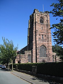
    St Mary's Church, Widnes

    In the 2021 census, Christianity was the main religion in Halton at 58.6%, above the national average for England of 46.3% but down from 75% in 2011. 35.2% stated that they had 'no religion'. Those stating their religion as Buddhist, Hindu, Jewish, Muslim, Sikh or other amounted to 1.6%.[4]

    Ethnicity[edit]

    In the 2021 census, 96.5% of Halton residents identified as White and 3.5% as non-White or mixed. 95.2% were born in the United Kingdom.[4]
    Governance[edit]

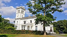
    Runcorn Town Hall

    Halton Borough Council is a unitary authority responsible for most local government functions within the area. The Labour Party has controlled the council since it was created in 1974.[12]

    On 1 April 2014, Halton became one of the six constituent local government districts of the Liverpool City Region under the Combined Authority.[13]

    Most of the borough is represented in the House of Commons by the member for Halton but Runcorn New Town is in the Weaver Vale constituency.

    Economy[edit]

    Chemical works at Weston Point

    In 2021, the borough's total GVA was £4.0 billion with a total GDP of £4.5 billion.[14] GVA per capita in Halton was £31,390 and GDP per capita was £34,985, the highest in the Liverpool City Region.[14]

    In 2022, there were 67,000 jobs in Halton, including the self-employed.[15] The borough is an industrial, scientific and logistics hub with a higher proportion of jobs in these industries, and proportionally fewer jobs in hospitality and education compared to Great Britain.[15] Proportionally more jobs were full-time roles.[15]

    In the period October 2022 to September 2023, the employment rate in Halton was 76.6%, higher than the average rate for Great Britain of 75.8%. Unemployment was 2.9% compared to 3.7% for Great Britain.[15]

    However, people in Halton are qualified to a lower level than the average for the North West or Great Britain.[15] In 2023, the gross median weekly wage for full time workers living in Halton was £664. Although higher than the regional median of £649, it is lower than the £682.60 for Great Britain.[15]

    Twin boroughs[edit]

    Halton is twinned with:

    Following an appeal in 1997, Halton residents donated 1,000 English books to Jan Evangelista Purkyně University in Ústí nad Labem.[16] In 1999, an historic Halton Transport bus was restored and gifted to the Czech Republic to mark the centenary of public transport in the city.[17] Engineers from Halton have assisted with chemical decontamination in the city and also when the city flooded in 2002.[18]

    The first crazy golf course in Berlin, created in Marzahn-Hellersdorf in 2005, contains several Halton landmarks and was constructed with the assistance of exchange students from the borough.[19]

    Several roads are named after Halton's twin boroughs, including Leiria Way in Runcorn and Marzahn Way in Widnes.[20] A Chinese friendship garden was created in the grounds of Runcorn Town Hall in 2006, including a bronze statue gifted by the twin city of Tongling.[21]

    See also[edit]

    References[edit]

    1. ^ "Council and Democracy". Halton Borough Council. Retrieved 19 May 2024.
  • ^ "Mid-Year Population Estimates, UK, June 2022". Office for National Statistics. 26 March 2024. Retrieved 3 May 2024.
  • ^ a b "Mid-Year Population Estimates, UK, June 2022". Office for National Statistics. 26 March 2024. Retrieved 3 May 2024.
  • ^ a b c d e UK Census (2021). "2021 Census Area Profile – Halton Local Authority (E06000006)". Nomis. Office for National Statistics. Retrieved 8 August 2023.
  • ^ "Parish Councils". Halton Borough Council. Archived from the original on 19 July 2018. Retrieved 19 July 2018.
  • ^ "Unitary Authority". Halton Borough Council. Archived from the original on 22 September 2008. Retrieved 19 January 2009.
  • ^ Wood, Bruce (1976). The process of local government reform 1966–74. London: Allen and Unwin. ISBN 0-04-350052-8.
  • ^ "1970 Conservative Party Manifesto". conservativemanifesto.com. Archived from the original on 4 June 2021. Retrieved 18 October 2020.
  • ^ Clay, Oliver, Halton to become part of Liverpool city region, Runcorn & Widnes Weekly News, archived from the original on 27 July 2011, retrieved 15 January 2009
  • ^ "FAQ: Working with our Statistical Data". A Vision of Britain Through Time. University of Portsmouth. Retrieved 11 August 2023.
  • ^ "Halton UA through time - Population Statistics". A Vision of Britain Through Time. University of Portsmouth. Archived from the original on 20 July 2020. Retrieved 11 August 2023.
  • ^ "Halton". BBC News Online. 19 April 2008. Archived from the original on 5 May 2008. Retrieved 3 March 2010.
  • ^ "Proposal to establish a combined authority for Greater Merseyside" (PDF). Department for Communities and Local Government. November 2013. Archived (PDF) from the original on 11 December 2013. Retrieved 10 December 2013.
  • ^ a b Fenton, Trevor (25 April 2023). "Regional gross domestic product: local authorities". Office for National Statistics. Retrieved 13 December 2023.
  • ^ a b c d e f "Labour Market Profile - Halton". Nomis. Office for National Statistics. Retrieved 17 February 2024.
  • ^ "Thanks to Halton". Warrington Guardian. Newsquest Media Group Ltd. 8 April 1997. Archived from the original on 18 February 2022. Retrieved 2 November 2020.
  • ^ "Halton - Ústí nad Labem City Hall". Ústí nad Labem City Council. Archived from the original on 1 December 2020. Retrieved 2 November 2020.
  • ^ "Forgiving but not forgetting Czechs' war". Cheshire Live. Reach plc. 19 May 2005. Archived from the original on 18 February 2022. Retrieved 2 November 2020.
  • ^ "Golf course putts Halton on the map". Cheshire Live. Reach plc. 25 August 2005. Archived from the original on 18 February 2022. Retrieved 2 November 2020.
  • ^ "Going Deutsche". Warrington Guardian. Newsquest Media Group Ltd. 21 July 2004. Archived from the original on 18 February 2022. Retrieved 2 November 2020.
  • ^ "Friendship garden is full of Eastern promise". Cheshire Live. Reach plc. 22 June 2006. Archived from the original on 1 February 2021. Retrieved 2 November 2020.

  • Retrieved from "https://en.wikipedia.org/w/index.php?title=Borough_of_Halton&oldid=1228523074"

    Categories: 
    Borough of Halton
    Liverpool City Region
    Unitary authority districts of England
    Districts of Cheshire
    Districts of England established in 1974
    Boroughs in England
    Hidden categories: 
    Pages using gadget WikiMiniAtlas
    Articles with short description
    Short description is different from Wikidata
    Wikipedia indefinitely move-protected pages
    Use dmy dates from February 2021
    Use British English from July 2012
    Articles containing Latin-language text
    Pages using infobox settlement with possible motto list
    Coordinates on Wikidata
    Articles with VIAF identifiers
    Articles with WorldCat Entities identifiers
    Articles with J9U identifiers
    Articles with LCCN identifiers
    Articles with MusicBrainz area identifiers


    This page was last edited on 11 June 2024, at 18:10 (UTC).

    Text is available under the Creative Commons Attribution-ShareAlike License 4.0; additional terms may apply. By using this site, you agree to the Terms of Use and Privacy Policy. Wikipedia® is a registered trademark of the Wikimedia Foundation, Inc., a non-profit organization.


    Privacy policy

    About Wikipedia

    Disclaimers

    Contact Wikipedia

    Code of Conduct

    Developers

    Statistics

    Cookie statement

    Mobile view


    Wikimedia Foundation
    Powered by MediaWiki