
Harrisburg International Airport
| |||||||||||
|---|---|---|---|---|---|---|---|---|---|---|---|

2018 aerial view of Harrisburg International Airport
| |||||||||||
| |||||||||||
| Summary | |||||||||||
| Airport type | Public/military | ||||||||||
| Owner/Operator | Susquehanna Area Regional Airport Authority | ||||||||||
| Serves | Harrisburg, Pennsylvania, U.S. | ||||||||||
| Location | Middletown, Pennsylvania, U.S. | ||||||||||
| Hub for | Wiggins Airways[1] | ||||||||||
| Elevation AMSL | 310 ft / 94 m | ||||||||||
| Coordinates | 40°11′35″N 076°45′48″W / 40.19306°N 76.76333°W / 40.19306; -76.76333 | ||||||||||
| Website | www.FlyHIA.com | ||||||||||
| Maps | |||||||||||
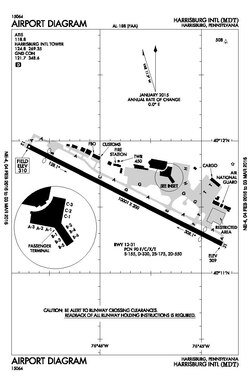 FAA diagram of the airport | |||||||||||
 | |||||||||||
| Runways | |||||||||||
| |||||||||||
| Statistics (2023) | |||||||||||
| |||||||||||
Harrisburg International Airport (IATA: MDT, ICAO: KMDT, FAA LID: MDT) is a public airport in Middletown, Pennsylvania,[4] United States, nine miles (15 km) southeast of Harrisburg. It is owned by the Susquehanna Area Regional Airport Authority.[5]
The airport code MDT refers to Middletown, the town in which the airport is located. Planes landing at MDT from the south are often routed near Three Mile Island Nuclear Generating Station a few miles from the airport. The airport, frequently referred to as HIA, is the primary commercial airport in South Central Pennsylvania and is the third-busiest airport in Pennsylvania for passenger enplanements and cargo shipments behind Philadelphia International Airport and Pittsburgh International Airport.[6][7]

Harrisburg International Airport has been serving south-central Pennsylvania since the late 19th century..[8] Beginning in 1898, the Signal Corps of the U.S. Army was stationed here. This was followed by the first military airplanes landing in 1918 at what had become Olmsted Field of the fledgling U.S. Army Air Service.
The Middletown Air Depot, later renamed Middletown Air Materiel Area at Olmsted, provided logistical and maintenance support of military aircraft until it closed in 1969. In 1968, airline flights moved from Capital City Airport to the former U.S. Air Force base, renamed as Olmstead State Airport. The airport was renamed Harrisburg International Airport in 1973.[9] Architect William Pereira designed the new terminals, completed in 1973.
Prior to deregulation, Harrisburg was served by Allegheny Airlines with flights to several Northeast destinations, Trans World Airlines with flights to Chicago, and Altair Airlines with commuter flights within Pennsylvania.[10]
In 1998, the Commonwealth transferred ownership to the Susquehanna Area Regional Airport Authority (SARAA). The Authority board consists of community volunteers appointed to staggered, five-year terms by the elected officials from Cumberland, Dauphin, and York counties, the cities of Harrisburg and York, and Fairview and Lower Swatara townships.
A new 360,000 square-foot terminal was completed in 2004. It cost $120 million and was designed by the Sheward Partnership.[11]
As of 2008, about 1,400 people work in the system of Harrisburg International Airport.[12]


Harrisburg International Airport covers 680 acres (280 ha) at an elevation of 310 feet (94 m) above mean sea level. It has one asphalt runway, 13/31, 10,001 by 200 feet (3,048 by 61 m).[5][13]
Runway 13 has a CAT III approach allowing operations down to 600 feet (180 m) RVR (Runway Visual Range). The airport has a Surface Movement Guidance Control System (SMGCS) that allows aircraft and vehicle ground movements during reduced visibility (below 1,200 feet (370 m) RVR down to 600 feet (180 m) RVR).
The airfield also boasts a 140-foot control tower and associated approach control staffed and operated by FAA air traffic controllers.
In the year ending December 31, 2021, the airport had 48,788 aircraft operations, an average of 134 per day: 26% air taxi, 29% general aviation, 27% scheduled commercial and 18% military. 29 aircraft were then based at this airport: 6 single-engine, 4 multi-engine, 11 jet, and 8 military.[5]
The terminal has 12 gates and is a pier finger lay out near the middle of the airfield, almost parallel to the runway. Delta Air Lines uses A1 and A3. United Airlines uses B1 and B3. Allegiant Air uses B6. American Airlines uses B2, and C1–C3. Gate A2, B4, and B5 are currently unused.[14]
Built in 2004, and attached to the new terminal building via a climate-controlled sky bridge, the Multi-Modal Transportation Facility (MMTF) is a four-story facility that handles all ground transportation. The top three levels have 2,504 parking places for Short-Term Hourly, Daily, and Long-Term public parking. The first level accommodates all limos, taxis, hotel shuttles, public and charter buses, plus the rental car ready/return lot.[15]
In the first floor lobby area are six rental car counters, restrooms, flight and bus information displays, and a seating area. On the second floor of the lobby area, climate-controlled moving sidewalks connect to the aerial walkway to the terminal.[15]
Route 7 of the Capital Area Transit System runs to downtown Harrisburg and surrounding communities. The Middletown Amtrak Station, about 3 miles (5 km) east of the terminal, has Amtrak service via the Keystone Corridor. There had been a proposal to construct a new rail terminal adjacent to the MMTF, but the final location chosen for the new station is about 2 miles (3.2 km) east, in Middletown.[16]
This section needs to be updated. Please help update this article to reflect recent events or newly available information. (January 2022)
|
| Airlines | Destinations | Refs |
|---|---|---|
| Allegiant Air | Fort Lauderdale, Jacksonville (FL),[17] Orlando/Sanford, Punta Gorda (FL), Sarasota, St. Petersburg/Clearwater Seasonal: Myrtle Beach, Nashville | [18] |
| American Airlines | Charlotte, Dallas/Fort Worth | [19] |
| American Eagle | Boston, Charlotte, Chicago–O'Hare, Philadelphia | [19] |
| Delta Air Lines | Atlanta | [20] |
| Delta Connection | Detroit Seasonal: Atlanta | [20] |
| United Airlines | Chicago–O'Hare | [21] |
| United Express | Chicago–O'Hare, Newark (ends June 26, 2024),[22] Washington–Dulles (begins June 27, 2024)[22] | [21] |
| Passenger destinations map |
|---|
 Harrisburg Red = Year-round destination Green = Seasonal destination |
Harrisburg International Airport has freight-forwarding capability. The airport is next to I-76 (Pennsylvania Turnpike), I-83, and I-81, allowing fast transfer of goods. Three major air cargo shippers maintain air service at the east end of the airport in an apron area next to the runway:[23]
| Airlines | Destinations |
|---|---|
| Ameriflight | Allentown, Newark, Wilkes-Barre/Scranton |
| FedEx Express | Baltimore, Indianapolis, Memphis, Newburgh Seasonal: Greensboro, Raleigh/Durham, Syracuse, Washington–Dulles |
| FedEx Feeder | Newark, Williamsport, Wilkes–Barre/Scranton[24] |
| UPS Airlines | Chicago/Rockford, Louisville, Philadelphia Seasonal: Anchorage, Dallas-Fort Worth, Hartford, Ontario |
| Rank | City | Passengers | Carriers |
|---|---|---|---|
| 1 | Charlotte, North Carolina | 134,420 | American |
| 2 | Chicago–O'Hare, Illinois | 113,110 | American, United |
| 3 | Atlanta, Georgia | 94,150 | Delta |
| 4 | Philadelphia, Pennsylvania | 48,050 | American |
| 5 | Dallas/Fort Worth, Texas | 47,380 | American |
| 6 | Orlando–Sanford, Florida | 39,730 | Allegiant |
| 7 | Newark, New Jersey | 31,630 | United |
| 8 | Detroit, Michigan | 26,840 | Delta |
| 9 | Clearwater, Florida | 22,780 | Allegiant |
| 10 | Orlando, Florida | 21,480 | Frontier |
| Rank | Airline | Passengers | Share |
|---|---|---|---|
| 1 | Allegiant Airlines | 251,000 | 19.24% |
| 2 | Piedmont Airlines | 208,000 | 15.92% |
| 3 | American Airlines | 186,000 | 14.24% |
| 4 | Delta Airlines | 156,000 | 11.98% |
| 5 | PSA Airlines | 113,000 | 8.66% |
| Other | 391,000 | 29.95% |
| Rank | Airline | Share |
|---|---|---|
| 1 | American Airlines | 40.8% |
| 2 | Allegiant Airlines | 19.5% |
| 3 | Delta Airlines | 19.1% |
| 4 | United Airlines | 17.4% |
| 5 | Frontier Airlines | 3.1% |
| Passengers | Change from previous year | Cargo (tons) | |
|---|---|---|---|
| 2013 | 1,294,632 | 54,344 | |
| 2014 | 1,289,487 | 48,922 | |
| 2015 | 1,173,938 | 51,401 | |
| 2016 | 1,205,461 | 52,807 | |
| 2017 | 1,195,763 | 51,886 | |
| 2018 | 1,294,765 | 57,303 | |
| 2019 | 1,512,585 | 55,268 | |
| 2020 | 633,310 | 55,430 | |
| 2021 | 1,021,110 | 63,549 | |
| 2022 | 1,256,348 | 57,175 | |
| 2023 | 1,303,990 | 53,940 |


Despite the closure of Olmsted AFB in 1969, the US Air Force continues an Air National Guard presence at Harrisburg[28] in the form of Harrisburg Air National Guard Station and the Pennsylvania Air National Guard's 193rd Special Operations Wing (193 SOW), an Air Force Special Operations Command (AFSOC)-gained unit flying the EC-130J Commando Solo aircraft. The 193 SOW is the sole operator of this critical aircraft asset for the entire US Air Force and in 2001 transitioned from the EC-130E to the new EC-130J variant. The wing has seen extensive federal service in recent years in support of Operations Just Cause, Desert Storm, Enduring Freedom and Iraqi Freedom.

The Air Force Presidential Airlift Squadron uses MDT as a practice airport for a number of reasons: its runway is long enough for a loaded 747, relatively low traffic, close proximity to Andrews Air Force Base, and the presence of the Air National Guard at MDT.
|
Airports in the Susquehanna Valley
| |
|---|---|
| Airport System |
|
| International Airport |
|
| Regional Airports |
|
| Military Airport |
|
| International |
|
|---|---|
| National |
|