Jump to content


Main menu


Navigation  


Main page
Contents
Current events
Random article
About Wikipedia
Contact us
Donate


Contribute  


Help
Learn to edit
Community portal
Recent changes
Upload file


Search  


Create account

Log in


Create account
 Log in


Pages for logged out editors learn more  


Contributions
Talk


Contents


(Top)


1 Local Features and Landmarks  


2 References  


3 External links  


Hartest


 / Bân-lâm-gú
Cebuano
Deutsch
فارسی
Français
Ladin
Nederlands
Polski
Simple English
Svenska
Türkçe
 

Edit links


Article
Talk


Read
Edit
View history


Tools


Actions  


Read
Edit
View history


General  


What links here
Related changes
Upload file
Special pages
Permanent link
Page information
Cite this page
Get shortened URL
Download QR code
Wikidata item


Print/export  


Download as PDF
Printable version


In other projects  


Wikimedia Commons


Appearance


Coordinates: 52°0824N 0°4044E / 52.13995°N 0.67878°E / 52.13995; 0.67878
 

From Wikipedia, the free encyclopedia


Hartest

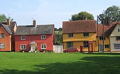
Bright cottages lining the green at Hartest

Hartest is located in Suffolk
Hartest

Hartest

Location within Suffolk

Population446 {2011}[1]
OS grid referenceTL834524
District
Shire county
Region
CountryEngland
Sovereign stateUnited Kingdom
Post townBURY ST EDMUNDS
Postcode districtIP29
Dialling code01284
PoliceSuffolk
FireSuffolk
AmbulanceEast of England
UK Parliament
List of places
UK
England
Suffolk
52°08′24N 0°40′44E / 52.13995°N 0.67878°E / 52.13995; 0.67878

Hartest is a small village and civil parish in the Babergh district of the English county of Suffolk. It is located halfway between Bury St. Edmunds and Sudbury on the B1066 road in the Glem valley. Brockley is two miles north.

The village of Hartest dates back to before 1086 and features in the Domesday Book.[2] The name 'Hartest' is thought to mean either 'Stag Hill' or 'Stag Wood'.[3] It is claimed that there are no other villages, towns or cities in the world of the same name.[4]

The village is centred on the large village green, fringed by an array of brightly coloured cottages, the village hall or institute, the medieval All Saints church and the Crown public house, formerly Hartest Hall the local landowner's seat. There is an annual fete held on the village green at the end of August each year.[5]

Running east of the village centre is Hartest Hill, the steepest in Suffolk.[6]

Former Special Envoy for the Archbishop of Canterbury and Islamic Jihad Organization hostage, Terry Waite lives in the village.[7]

Local Features and Landmarks[edit]

On the north side of the village green stands a large boulder named the 'Hartest Stone'.[8] This boulder, thought to have been placed on that spot in the early 18th century,[9] has attracted speculation over its origins. One theory is that the boulder was moved by sled from the nearby Somerton Hill to celebrate the Peace of Utrecht and the Duke of Marlborough's victories in the War of the Spanish Succession.[10] Another theory suggests the boulder was moved (for the same reasons) from Somerton Common.[11] A third theory suggests the boulder was found in a clay pit owned by one Mr Carter, who had the stone moved to its current location.[12] Local traditions say that the boulder will turn over at the stroke of midnight and sitting on the boulder at midnight will bring a wife or good fortune.[13]

Hartest Wood stands on the outskirts of Hartest. The wood was planted in 1999 as part of the Woodland Trust's 'Woods on your doorstep' scheme[14] to commemorate the new millennium. The wood contains 187 oak trees, representing every household in Hartest at the time.[15] At the centre of the woods an art installation designed by Geoffrey Clarke called 'The Gift' can be found.[16]

The village pub, The Crown (previously 'the Crown Inn')[17] stands on the South side of the green. The Crown is a sixteenth century Grade II Listed building[18] and was previously used as a Moot Hall for the village and surrounding area.[19]

References[edit]

  1. ^ "Parish population 2011". Retrieved 12 September 2015.
  • ^ "Place: Hartest". domesdaymap.co.uk/. Open Domesday. Archived from the original on 3 November 2014. Retrieved 3 November 2014.
  • ^ "Parish: Hartest" (PDF). suffolk.gov. Suffolk County Council. Retrieved 3 November 2014.
  • ^ "Hartest". onesuffolk.net. OneSuffolk. Retrieved 3 November 2014.
  • ^ "Hartest.onesuffolk news and events".
  • ^ "Hartest Hill - Hartest, Suffolk". climbbybike.com. Climb By Bike. Retrieved 3 November 2014.
  • ^ "Terry Waite returning to Beirut". BBC. 16 February 2004. Retrieved 16 December 2010.
  • ^ "The Hartest Stone". secretsuffolk.com. Secret Suffolk. Retrieved 3 November 2014.
  • ^ "300 Year Celebration of the Hartest Stone". onesuffolk.net. One Suffolk. Archived from the original on 3 November 2014. Retrieved 3 November 2014.
  • ^ Mitchell, Laurence (2014). Suffolk : local, characterful guides to Britain's special places (First ed.). Bradt Travel Guides Ltd. p. 210. ISBN 9781841625508.
  • ^ "1905 Suffolk & Essex Free Press newspaper archive". www.foxearth.org.uk. The Foxearth and District Local History Society. Retrieved 3 November 2014.
  • ^ The East Anglian, or Notes & Queries, Vol.3. Samuel Tymms, Whittaker and Co. 1869. p. 238.
  • ^ Burgess, Mike. "Hidden East Anglia: Hartest". hiddenea.com. Retrieved 3 November 2014.
  • ^ "Hartest Wood". woodlandtrust.org.uk. The Woodland Trust. Retrieved 3 November 2014.
  • ^ Barr, Peter. "Hartest Wood". geograph.org.uk. Geograph: Photograph every grid square. Retrieved 3 November 2014.
  • ^ "Hartest, Suffolk". runninginsuffolk.wordpress.com. Running in Suffolk. Retrieved 3 November 2014.
  • ^ "Crown Inn, Hartest, Bury St Edmunds". pubshistory.com. Pubs History. Retrieved 3 November 2014.
  • ^ "Crown Inn, Hartest". www.britishlistedbuildings.co.uk/. British Listed Buildings. Retrieved 3 November 2014.
  • ^ "Hartest with Boxted and Somerton" (PDF). discoversuffolk.org.uk. Suffolk Sounty Council: Suffolk Paths Partnership. Archived from the original (PDF) on 3 November 2014. Retrieved 3 November 2014.
  • External links[edit]


  • t
  • e

  • Retrieved from "https://en.wikipedia.org/w/index.php?title=Hartest&oldid=1105143152"

    Categories: 
    Villages in Suffolk
    Babergh District
    Civil parishes in Suffolk
    Suffolk geography stubs
    Hidden categories: 
    Pages using gadget WikiMiniAtlas
    Articles with short description
    Short description is different from Wikidata
    Use dmy dates from October 2019
    Articles with OS grid coordinates
    Coordinates on Wikidata
    Commons category link is on Wikidata
    Articles with J9U identifiers
    All stub articles


    This page was last edited on 18 August 2022, at 19:19 (UTC).

    Text is available under the Creative Commons Attribution-ShareAlike License 4.0; additional terms may apply. By using this site, you agree to the Terms of Use and Privacy Policy. Wikipedia® is a registered trademark of the Wikimedia Foundation, Inc., a non-profit organization.


    Privacy policy

    About Wikipedia

    Disclaimers

    Contact Wikipedia

    Code of Conduct

    Developers

    Statistics

    Cookie statement

    Mobile view


    Wikimedia Foundation
    Powered by MediaWiki