
Heino
| |
|---|---|
Village
| |

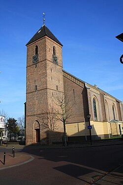
Heino church: de Nederlands Hervormde Zaalkerk
| |
|
Location in province of Overijssel in the Netherlands Show map of OverijsselHeino (Netherlands) Show map of Netherlands | |
| Coordinates: 52°26′9″N 6°14′2″E / 52.43583°N 6.23389°E / 52.43583; 6.23389 | |
| Country | Netherlands |
| Province | Overijssel |
| Municipality | Raalte |
| Area | |
| • Total | 22.04 km2 (8.51 sq mi) |
| Elevation | 3.6 m (11.8 ft) |
| Population
(2021)[1]
| |
| • Total | 7,170 |
| • Density | 330/km2 (840/sq mi) |
| Time zone | UTC+1 (CET) |
| • Summer (DST) | UTC+2 (CEST) |
| Postal code |
8141[1]
|
| Dialing code | 0572 |
| Website | www |
Heino is a village in the province of Overijssel in the Netherlands. It belongs to the municipality of Raalte and it has 7,080 inhabitants (January 2018). The village has a railway station along the railway Zwolle - Enschede and it can also be reached by the road N35.
Heino was a separate municipality until 2001, when it merged with Raalte to form a new municipality with the name Raalte.[3]
Heino is a very touristic village with many estates and country houses. South-west of Heino, just across the railroad and the border to the municipality Olst-Wijhe, stands the castle Nijenhuis. It hosts an important art museum ( Constant Permeke, Van Gogh et al.). Around the castle is a sculpture garden (Ossip Zadkine et al.).
Every third week of August the village celebrates the 'Pompdagen' (Pumpdays), mentioned after the local Leugenpompe[4] village pump. The highlight of a series of joyful events is the so-called "Daggie Old Heino", including trades and handicraft from the past; markets and folk music. It draws thousands of visitors to Heino.
| Climate data for Heino (1991−2020 normals, extremes 1989−present) | |||||||||||||
|---|---|---|---|---|---|---|---|---|---|---|---|---|---|
| Month | Jan | Feb | Mar | Apr | May | Jun | Jul | Aug | Sep | Oct | Nov | Dec | Year |
| Record high °C (°F) | 14.5 (58.1) |
19.3 (66.7) |
23.7 (74.7) |
28.6 (83.5) |
31.5 (88.7) |
34.7 (94.5) |
39.3 (102.7) |
35.4 (95.7) |
32.2 (90.0) |
26.3 (79.3) |
19.7 (67.5) |
15.0 (59.0) |
39.3 (102.7) |
| Mean daily maximum °C (°F) | 5.5 (41.9) |
6.5 (43.7) |
10.1 (50.2) |
14.6 (58.3) |
18.2 (64.8) |
20.9 (69.6) |
23.0 (73.4) |
22.7 (72.9) |
19.2 (66.6) |
14.5 (58.1) |
9.5 (49.1) |
6.1 (43.0) |
14.2 (57.6) |
| Daily mean °C (°F) | 3.0 (37.4) |
3.3 (37.9) |
5.9 (42.6) |
9.3 (48.7) |
13.0 (55.4) |
15.8 (60.4) |
17.9 (64.2) |
17.4 (63.3) |
14.2 (57.6) |
10.5 (50.9) |
6.6 (43.9) |
3.7 (38.7) |
10.0 (50.0) |
| Mean daily minimum °C (°F) | 0.2 (32.4) |
0.1 (32.2) |
1.6 (34.9) |
3.5 (38.3) |
7.1 (44.8) |
10.2 (50.4) |
12.4 (54.3) |
11.9 (53.4) |
9.4 (48.9) |
6.5 (43.7) |
3.5 (38.3) |
1.0 (33.8) |
5.6 (42.1) |
| Record low °C (°F) | −17.5 (0.5) |
−17.9 (−0.2) |
−17.2 (1.0) |
−7.9 (17.8) |
−2.2 (28.0) |
−0.1 (31.8) |
4.6 (40.3) |
4.0 (39.2) |
0.0 (32.0) |
−6.8 (19.8) |
−9.7 (14.5) |
−15.4 (4.3) |
−17.9 (−0.2) |
| Average precipitation mm (inches) | 66.4 (2.61) |
57.0 (2.24) |
54.6 (2.15) |
40.7 (1.60) |
58.4 (2.30) |
68.4 (2.69) |
81.9 (3.22) |
79.8 (3.14) |
62.4 (2.46) |
67.9 (2.67) |
64.8 (2.55) |
72.1 (2.84) |
774.4 (30.49) |
| Average relative humidity (%) | 88.7 | 85.5 | 81.3 | 76.1 | 75.5 | 77.1 | 78.7 | 81.0 | 84.8 | 87.1 | 90.1 | 90.1 | 83.0 |
| Mean monthly sunshine hours | 62.9 | 92.5 | 141.8 | 191.8 | 214.1 | 205.1 | 215.7 | 194.4 | 154.2 | 119.9 | 65.3 | 54.9 | 1,712.6 |
| Percent possible sunshine | 24.6 | 33.0 | 38.4 | 45.9 | 43.9 | 40.8 | 42.7 | 42.6 | 40.4 | 36.3 | 24.7 | 22.5 | 36.3 |
| Source: Royal Netherlands Meteorological Institute[5][6] | |||||||||||||
| International |
|
|---|---|
| National |
|
| Geographic |
|