Jump to content


Main menu


Navigation  


Main page
Contents
Current events
Random article
About Wikipedia
Contact us
Donate


Contribute  


Help
Learn to edit
Community portal
Recent changes
Upload file


Search  


Create account

Log in


Create account
 Log in


Pages for logged out editors learn more  


Contributions
Talk


Contents


(Top)


1 References  


Hengduan Mountains subalpine conifer forests


Español
فارسی
Français

Italiano
Українська
 

Edit links


Article
Talk


Read
Edit
View history


Tools


Actions  


Read
Edit
View history


General  


What links here
Related changes
Upload file
Special pages
Permanent link
Page information
Cite this page
Get shortened URL
Download QR code
Wikidata item


Print/export  


Download as PDF
Printable version


In other projects  


Wikimedia Commons


Appearance


From Wikipedia, the free encyclopedia


Hengduan Mountains subalpine conifer forests
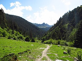
Conifer forests at the treeline in the Chola Mountain foothills in Dêgê County
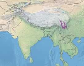
Location of ecoregion
Ecology
RealmPalearctic
BiomeTemperate coniferous forests
Geography
CountryChina

The Hengduan Mountains subalpine conifer forests are a temperate forest in the Hengduan Mountainsofsouthwestern China.[1] The forests extend within the Jinsha (upper Yangtze) and Yalong River valleys from approximately 32°N to 27°N. In addition, a portion of the Anning River valley and Mianmian Mountains near Lugu Lake support the subalpine conifer forests. This region covers northern Yunnan Province, western Sichuan Province, and the extreme eastern edge of the Tibet Autonomous Region.[2]

The Hengduan Mountains subalpine conifer forests are one zone in a range of montane ecosystems that transition between tropical and temperate ecoregions along the southeastern fringe of the Tibetan Plateau. The Hengduan forests reach elevations higher than 4,000 m (13,000 ft) and extend to the treeline, beyond which are montane grasslands and shrublands classified as the Southeast Tibet shrub and meadows.[1] The Hengduan conifer forests are separated into two arms by the Shaluli Mountains.

Environmental groups have recognized this ecoregion as being threatened by "a growing human population and the resulting demand for non-timber forests and wildlife products for medicinal and other uses".[3]

References

[edit]
  1. ^ a b "Hengduan Mountains subalpine conifer forests". WWF. World Wildlife Fund. Retrieved 16 August 2017.
  • ^ "Hengduan Mountains subalpine conifer forests". Global Species. Myers Enterprises II. Retrieved 16 August 2017.
  • ^ Ecoregions at panda.org Archived February 15, 2006, at the Wayback Machine
  • t
  • e

  • Retrieved from "https://en.wikipedia.org/w/index.php?title=Hengduan_Mountains_subalpine_conifer_forests&oldid=1050240013"

    Categories: 
    Flora of Tibet
    Ecoregions of Asia
    Ecoregions of China
    Forests of China
    Montane forests
    Palearctic ecoregions
    Temperate coniferous forests
    Ecoregion stubs
    Hidden categories: 
    Webarchive template wayback links
    Articles with short description
    Short description is different from Wikidata
    All stub articles


    This page was last edited on 16 October 2021, at 17:05 (UTC).

    Text is available under the Creative Commons Attribution-ShareAlike License 4.0; additional terms may apply. By using this site, you agree to the Terms of Use and Privacy Policy. Wikipedia® is a registered trademark of the Wikimedia Foundation, Inc., a non-profit organization.


    Privacy policy

    About Wikipedia

    Disclaimers

    Contact Wikipedia

    Code of Conduct

    Developers

    Statistics

    Cookie statement

    Mobile view


    Wikimedia Foundation
    Powered by MediaWiki