Jump to content


Main menu


Navigation  


Main page
Contents
Current events
Random article
About Wikipedia
Contact us
Donate


Contribute  


Help
Learn to edit
Community portal
Recent changes
Upload file


Search  


Create account

Log in


Create account
 Log in


Pages for logged out editors learn more  


Contributions
Talk


Contents


(Top)


1 History  


2 Later periods  


3 References  


Heptastadion


العربية
Français
Italiano
Latina

Русский
Srpskohrvatski / српскохрватски
Türkçe
 

Edit links


Article
Talk


Read
Edit
View history


Tools


Actions  


Read
Edit
View history


General  


What links here
Related changes
Upload file
Special pages
Permanent link
Page information
Cite this page
Get shortened URL
Download QR code
Wikidata item


Print/export  


Download as PDF
Printable version


Appearance


Coordinates: 31°1158N 29°5306E / 31.19944°N 29.88500°E / 31.19944; 29.88500
 

From Wikipedia, the free encyclopedia


Heptastadion
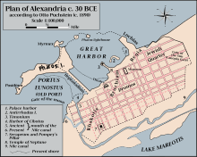
Map of ancient Alexandria, with the Heptastadion shown linking Pharos Island to the mainland.
Heptastadion is located in Egypt
Heptastadion

Map of Egypt showing the location of the Heptastadion.

LocationAlexandria
RegionEgypt
Coordinates31°11′58N 29°53′06E / 31.19944°N 29.88500°E / 31.19944; 29.88500
Altitude0 m (0 ft)
TypeMole
Part ofAlexandria Port
Length1,260 metres (4,130 ft)
History
BuilderPtolemy I
Foundedc. 300 BC
CulturesPtolemaic Kingdom
EventsCaesar's Civil War
Site notes
ConditionBuried

The Heptastadion (Greek: Ὲπταστάδιον) was a giant causeway, often referred to as a mole[1] or a dyke built by the people of Alexandria, Egypt in the 3rd century BC during the Ptolemaic period.[2] The Heptastadion was created to link Pharos Island to the mainland coast and given a name based on its length (Heptastadion is Greek for "seven stadia"— hepta meaning seven, and a stadion being a Greek unit of length measuring approximately 180 m (590 ft)).[3] Overall it was more than three-quarters of a mile long.

History

[edit]

Alexander the Great founded the city of Alexandria in April 331 BC on the site of the small fishing village of Rhacotis as the marine base for his fleet. The city was built on a narrow limestone ridge[4] opposite to Pharos Island where the Pharos lighthouse would later stand.[5] Forces under Alexander's command cleared the sand and silt deposits which made the port unnavigable, and Alexander's engineer Dinocrates linked the port of Alexandria and the island of Pharos with a bridge 1,200 m (3,900 ft) long and 200 m (660 ft) wide, creating two harbour basins for commercial and military shipping. The northeast basin (currently the Eastern harbour) was designed for military vessels and the southwest basin (currently the main port of Alexandria) was for commercial use.

In the Ptolemaic period the lighthouse was constructed on the orders of Ptolemy I and II. It is probable that Ptolemy I was also responsible for the building of the Heptastadion.[6] The causeway formed a barrier further separating the two harbours of Alexandria's oceanfront. This arrangement had the advantage of protecting the harbours from the force of the strong westerly coastal current.[7] The east side of the mole became the Portus Magnus (the Great Harbour or Royal Harbour), now an open bay. The west side became the Portus Eunostus (the commercial harbour), with its inner basin Kibotos, now vastly enlarged to form the modern harbour.[8] Two channels with bridges above were let under the causeway to allow access between the two ports. Julius Caesar ordered these channels to be blocked during the Alexandrian War. The Heptastadion is also believed to have served as an aqueduct while Pharos was inhabited,[3] and geophysical research indicates that it was part of the road network of the ancient city.[9]

Later periods

[edit]

Due to silting over the years,[1] the former dyke now lies under several metres of accumulated silt and soil which form the Mansheya isthmus,[10] upon which the Ottomans built their town from 1517 onwards.[9] Today's city development lying between the present Grand Square and the modern Ras el-Tin quarter is built on the silt which gradually widened and obliterated the mole.

References

[edit]
  1. ^ a b Pearson, Birger Albert (2004). Gnosticism and Christianity in Roman and Coptic Egypt. Continuum International Publishing Group. p. 104. ISBN 0-567-02610-8.
  • ^ Khalid S. Al-Hagla. "Cultural Sustainability: An Asset of Cultural Tourism Industry" (PDF). International Cetre for Research on the Economics of Culture, Institutions, and Creativity (EBLA). Archived from the original (PDF) on 2007-07-21.
  • ^ a b Bertrand Millet; Goiran, Jean-Philippe (2007). "Impacts of Alexandria's Heptastadion on Coastal Hydro-Sedimentary Dynamics During the Hellenistic Period". The International Journal of Nautical Archaeology. 36 (1): 167–176. doi:10.1111/j.1095-9270.2006.00131.x. S2CID 56330738.
  • ^ Pinchin, Jane Lagoudis (8 Mar 2015). Alexandria Still: Forster, Durrell, and Cavafy. Princeton University Press. p. 186. ISBN 9781400870714. Retrieved 28 March 2016.
  • ^ Smith, Sir William (1952). Everyman's Smaller Classical Dictionary. J. M. Dent & Sons Ltd. p. 222.
  • ^ Ellis, Walter M. (2003). Ptolemy of Egypt. Routledge. p. 50. ISBN 9781134856428. Retrieved 17 August 2015.
  • ^ "Egypt After the Pharaohs: Heptastadion". www.brown.edu. Brown University. Retrieved 17 July 2015.
  • ^ Arthur de Graauw (5 July 2011). "Ancient Ports – Ports Antiques: Alexandria". www.ancientportsantiques.com. Retrieved 17 July 2015.
  • ^ a b "Archaeologists and Geophysicists: The Heptastadion". www.cealex.org. Centre d'Études Alexandrines. Archived from the original on 23 September 2015. Retrieved 17 July 2015.
  • ^ "The Ptolemaic Legacy". Archived from the original on 2008-02-16. Retrieved 2008-02-11.

  • Retrieved from "https://en.wikipedia.org/w/index.php?title=Heptastadion&oldid=1228823651"

    Categories: 
    3rd-century BC establishments in Egypt
    Infrastructure completed in the 3rd century BC
    Causeways
    History of Alexandria
    Ptolemaic Alexandria
    Lighthouse of Alexandria
    Hellenistic architecture
    Ptolemy I Soter
    Hidden categories: 
    Pages using gadget WikiMiniAtlas
    Coordinates on Wikidata


    This page was last edited on 13 June 2024, at 11:24 (UTC).

    Text is available under the Creative Commons Attribution-ShareAlike License 4.0; additional terms may apply. By using this site, you agree to the Terms of Use and Privacy Policy. Wikipedia® is a registered trademark of the Wikimedia Foundation, Inc., a non-profit organization.


    Privacy policy

    About Wikipedia

    Disclaimers

    Contact Wikipedia

    Code of Conduct

    Developers

    Statistics

    Cookie statement

    Mobile view


    Wikimedia Foundation
    Powered by MediaWiki