
You can help expand this article with text translated from the corresponding article in Hebrew. Click [show] for important translation instructions. Content in this edit is translated from the existing Hebrew Wikipedia article at [[:he:כביש 70]]; see its history for attribution.{{Translated|he|כביש 70}} to the talk page. |
| Highway 70 | ||||
|---|---|---|---|---|
| כביש 70 | ||||

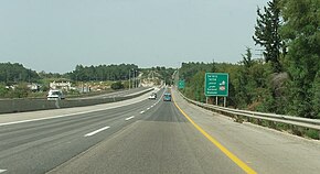
Highway 70 near the Somekh junction, before being upgraded to an interchange.
| ||||
| Route information | ||||
| Length | 44 km (27 mi) | |||
| Major junctions | ||||
| South end | Yagur Interchange | |||
| North end | Hanita Junction | |||
| Location | ||||
| Country | Israel | |||
| Highway system | ||||
| ||||
Highway 70 is a highway, 44 km in length, running through the Western Galilee region in the Northern DistrictofIsrael. It connects the Lower GalileetoKiryat Ata and Shlomi near Israel's border with Lebanon.
The highway runs concurrently with Highway 75 for 4 km between Ha'Amakim Interchange and Yagur Junction, then with Highway 6 for 5 km between Givot Alonim Interchange and Somekh Interchange.[1]
Highway 70 begins at the Yagur interchange with Highway 75, then goes north toward Kiryat Ata and Shefaram and afterward continues through the Western Galilee until Shlomi.
At the end of the 1990s, the two junctions near the southern end of the road, at Bat Shlomo and Elyakim, were reconstructed into interchanges to enable uninterrupted travel from Shefaya junction to Yokneam junction.
| District[2] | Location[3] | km | mi | Name | Destinations | Notes |
|---|---|---|---|---|---|---|
| Haifa | Yagur | 0 | 0.0 | מחלף יגור (Yagur Interchange) | ||
| Rekhasim | 1.4 | 0.87 | צומת דשנים (Deshanim Junction) | |||
| 2.4 | 1.5 | צומת חסידים (Hasidim Junction) | ||||
| Kiryat Ata | 3.9 | 2.4 | צומת זבולון (Zevulon Junction) | |||
| Khawaled | 6 | 3.7 | מחלף גבעות אלונים (Givot Alonim Interchange) | |||
| Kiryat Ata | 11 | 6.8 | מחלף סומך (Somekh Interchange) | |||
| Northern | Shfar'am | 13 | 8.1 | צומת אבליים (Avlayim Junction) | ||
| Tamra | 16 | 9.9 | צומת טמרה (Tamra Junction) | Entrance to Tamra | ||
| Kabul | 19 | 12 | צומת כאבול (Kabul Junction) | Entrance to Kabul | ||
| Yasur | 21 | 13 | צומת יבור (Yavor Junction) | |||
| Ahihud | 23.8 | 14.8 | צומת אחיהוד (Ahihud Junction) | Eastern end of concurrency with | ||
| Jadeidi-Makr | 24.3 | 15.1 | צומת יאסיף (Yassif Junction) | Western end of concurrency with | ||
| 25.4 | 15.8 | Entrance to Jadeidi-Makr | ||||
| Tal El | 26 | 16 | צומת טל-אל (Tal El Junction) | Entrance to Tal El | ||
| Julis | 27 | 17 | צומת ג'וליס (Julis Junction) | Entrance to Julis | ||
| Kfar Yassif | 29 | 18 | Entrance to Kfar Yassif | |||
| Beit HaEmek | 30.5 | 19.0 | Entrance to Beit HaEmek | |||
| Oshrat | 31 | 19 | צומת אשרת (Oshrat Junction) | Entrance to Oshrat | ||
| Amka | 32 | 20 | צומת עמקה (Amka Junction) | |||
| Sheikh Danun | 33 | 21 | צומת כליל (Klil Junction) | |||
| Netiv HaShayara | 34.5 | 21.4 | צומת השיירה (HaShayara Junction) | Entrance to Netiv HaShayara | ||
| Kabri | 37 | 23 | צומת כברי (Kabri Junction) | |||
| Avdon Manot | 40 | 25 | צומת עבדון (Avdon Junction) | |||
| Matzuva | 43 | 27 | צומת מצובה (Matzuva Junction) | Entrance to Matzuva | ||
| Shlomi | 44 | 27 | צומת חניתה (Hanita Junction) | |||
1.000 mi = 1.609 km; 1.000 km = 0.621 mi
| ||||||
|
| |||||
|---|---|---|---|---|---|
| Roads |
| ||||
| Bus operators |
| ||||
| Rail transport |
| ||||
| Cycling |
| ||||
| Sea ports |
| ||||
| Aviation |
| ||||
| Cable cars |
| ||||
| By city |
| ||||
| Smart cards |
| ||||
| |||||
32°45′34″N 35°05′03″E / 32.75944°N 35.08417°E / 32.75944; 35.08417