
Hilir Perak District
| |
|---|---|
| Daerah Hilir Perak | |
| Other transcription(s) | |
| • Jawi | هيلير ڤراق |
| • Chinese | 下霹雳县 |
| • Tamil | ஹீலிர் பேராக் |

Location of Hilir Perak DistrictinPerak
| |
 | |
|
Location of Hilir Perak DistrictinMalaysia | |
| Coordinates: 4°N 101°E / 4°N 101°E / 4; 101 | |
| Country | |
| State | |
| Seat | Teluk Intan |
| Local area government(s) | Teluk Intan Municipal Council |
| Government | |
| • District officer | Saidi Bin Haji Shaari, AMK[1] |
| Area | |
| • Total | 792.07 km2 (305.82 sq mi) |
| Population
(2016)
| |
| • Total | 128,179 |
| • Estimate
(2015)[3]
| 144,400 |
| • Density | 160/km2 (420/sq mi) |
| Time zone | UTC+8 (MST) |
| • Summer (DST) | UTC+8 (Not observed) |
| Postcode |
36000+36700
|
| Calling code | +6-05 |
| Vehicle registration plates | A |
Hilir Perak District (Lower Perak) is a districtinPerak, Malaysia. The district is governed by Teluk Intan Municipal Council which is based in the town of Teluk Intan. The District council was known as Hilir Perak District Council until 4 April 2004, when it was upgraded to Municipality status. Teluk Intan town is the district's principal urban center while smaller towns include Langkap town and Chenderong Balai town.
Teluk Intan town is on the southeast bank of the Perak River, opposite the kampong of Sungai Durian.[4]
Langkap town housing an Immigration Depot which is a detention centre for illegal immigrants around Perak state.
In January 2016 Bagan Datuk was declared an autonomous sub-district of Perak and later on 15 June 2016, Bagan Datoh was formed into a new district together with Hutan Melintang, detaching it from Hilir Perak (Teluk Intan). However Teluk Intan retains responsibility for the municipal works in the district.

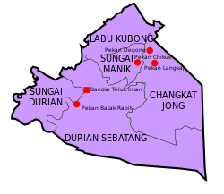
Hilir Perak District is divided into 5 mukims, which are:
Hilir Perak is a relatively flat plain compared to Ipoh, the state's capital. With the Perak River flowing through the district, it is a fertile area suitable for agricultural activities.
| Year | Pop. | ±% | ||
|---|---|---|---|---|
| 1991 | 202,059 | — | ||
| 2000 | 190,868 | −5.5% | ||
| 2010 | 202,593 | +6.1% | ||
| 2020 | 141,959 | −29.9% | ||
| ||||
| Figures before 2016 includes Bagan Datuk District. Source: [5] | ||||
List of Hilir Perak district representatives in the Federal Parliament (Dewan Rakyat)
| Parliament | Seat name | Member of Parliament | Party |
|---|---|---|---|
| P73 | Pasir Salak | Jamaluddin Yahya | Perikatan Nasional (PAS) |
| P76 | Teluk Intan | Nga Kor Ming | Pakatan Harapan (DAP) |
List of Hilir Perak district representatives in the State Legislative Assembly of Perak
| Parliament | State | Seat name | State Assemblyman | Party |
|---|---|---|---|---|
| P73 | N49 | Sungai Manik | Zainol Fadzi Paharudin | Perikatan Nasional (PPBM) |
| P73 | N50 | Kampung Gajah | Zafarulazlan Zan | Perikatan Nasional (PAS) |
| P76 | N55 | Pasir Bedamar | Woo Kah Leong | Pakatan Harapan (DAP) |
| P76 | N56 | Changkat Jong | Nadziruddin Mohamed Bandi | Perikatan Nasional (PPBM) |
There are a lot of schools that located in this district. The famous daily school are San Min National Type Secondary School, San Min Independent Secondary School, SMK Seri Perak, SMK Horley Methodist, SMK Convent, SMK Sultan Abdul Aziz and SMK St. Anthony. For boarding school, there are one boarding schools in this district, Sekolah Menengah Sains Teluk Intan and one technical school, Sekolah Menengah Teknik Teluk Intan.
There are 2 public university branch campuses located in this district. The campuses are UiTM Teluk Intan Campus [1] of Faculty of Medicine completed in October 2010 and UKM Teluk Intan Campus of Faculty of Medicine (currently under construction) . Both are located beside Hospital Teluk Intan. There are also a community school in Teluk Intan town.
Agriculture and fishing are two main economic activities in Hilir Perak. Almost two-thirds of Hilir Perak's agricultural land is planted with oil palms, while the one third goes to vegetables, paddy, coconuts etc. The biggest fishing town in Hilir Perak is Hutan Melintang, which has about 400 fishing ships of various sizes. Hutan Melintang fishermen sell their catches throughout the country. The vibrant agriculture and fishing industry in Hilir Perak had attracted many foreign workers into Hilir Perak. The fishing industry employs more Thais while Indonesians are largely employed in the agricultural sector.
There is also a light industrial area in Teluk Intan and Langkap which provides many work opportunities to the locals.
|
| |
|---|---|
| |
| Johor |
|
| Kedah |
|
| Kelantan |
|
| Malacca |
|
| Negeri Sembilan |
|
| Pahang |
|
| Penang |
|
| Perak |
|
| Perlis | Not Available (★Kangar) |
| Sabah |
|
| Sarawak |
|
| Selangor |
|
| Terengganu |
|
☆Kuala Lumpur, Labuan, and Putrajaya are Federal Territories and thus do not have districts. | |