Jump to content


Main menu


Navigation  


Main page
Contents
Current events
Random article
About Wikipedia
Contact us
Donate


Contribute  


Help
Learn to edit
Community portal
Recent changes
Upload file


Search  


Create account

Log in


Create account
 Log in


Pages for logged out editors learn more  


Contributions
Talk


Contents


(Top)


1 Demography  


2 City and towns  


2.1  Sibu  


2.2  Sibu Jaya  


2.3  Durin  


2.4  Kemuyang  


2.5  Rantau Panjang  


2.6  Pasai Siong  


3 Climate  


4 References  


Sibu District


 / Bân-lâm-gú
Français
Bahasa Melayu
ி
Tiếng Vit


Edit links


Article
Talk


Read
Edit
View history


Tools


Actions  


Read
Edit
View history


General  


What links here
Related changes
Upload file
Special pages
Permanent link
Page information
Cite this page
Get shortened URL
Download QR code
Wikidata item


Print/export  


Download as PDF
Printable version


In other projects  


Wikimedia Commons


Appearance


From Wikipedia, the free encyclopedia


Sibu District
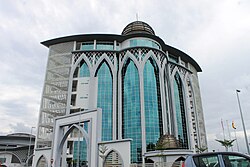
Sibu District Office is housed inside the Islamic complex.
Official logo of Sibu District
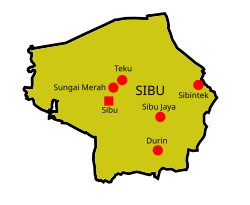
Location of Sibu District
District Office locationSibu
Local area government(s)Sibu Municipal Council (SMC)
Sibu Rural District Council (SRDC)
Area
 • Total2,229.8 km2 (860.9 sq mi)
Population
 (2010)[1]
 • Total240,165
 • Density110/km2 (280/sq mi)
District OfficerAwang Yusup bin Awang Mostapha
License plate prefixQS
Ethnicity[1]Chinese (47.2%)
Iban (28.0%)
Malay (10.0%)
Melanau (5.9%)
Non-Malaysians (5.9%)
Bidayuh (0.73%)
Websitehttp://www.sibudo.sarawak.gov.my/


Sibu District is an administrative district in Sibu Division, Sarawak, Malaysia covering a total area of 2229.8 km2.[2] It can be divided into Sibu Town area (129.5 km2)[3] and the rural areas (2,100.3 km2). The satellite township of Sibu Jaya (26 km away from the Sibu city) is included in the rural areas.[4] Sibu District is under the purview of Sibu District Office located at Sibu Islamic Complex, Sibu City. There are currently two local authorities namely Sibu Municipal Council (SMC)[3] and Sibu Rural District Council (SRDC)[5] that administers Sibu City and Sibu rural areas respectively.

Demography[edit]

There has been a marginal growth of Sibu District population of 2.36% from 1991 to 2000. Meanwhile, from 2000 to 2010, there is a marginal growth of 1.53%.[6]

Year 1991 2000 2010
Total
population
166,894 206,297 240,165

City and towns[edit]

Sibu[edit]

James Brooke built a fort in Sibu in 1862.[7] In 1901, 1,118 Fuzhounese settlers migrated to Sibu.[8] Today, Sibu is the largest city by the Rajang River.[9]

Sibu Jaya[edit]

Sibu Jaya developer office

Sibu Jaya is located at 26 km away from Sibu.[10] and 1 km away from Sibu Airport. It is a joint development project between AmCorp Corporation Sdn Bhd and Sarawak Housing and Development Corporation.[11] It was originally developed as a satellite township to Sibu in 1995.[12] The city is expected to be completed in 2023.[11]

Durin[edit]

Pesta Rakyat Durin (Durin Peoples' festival) is held at Durin bazaar every year.[13] Durin Bridge connecting the town of Sibu with Durin bazaar was opened in 2006.[14]

Kemuyang[edit]

Kemuyang area is located 23 km away from the town of Sibu. Sibu Kemuyang Youth Camp started operation 1999.[15] Sibu Pastoral Centre is also located here.[16]

Rantau Panjang[edit]

Rantau Panjang Integrated Shipyard Shipbuilding Industrial Zone was constructed in 2003.[17]

Pasai Siong[edit]

The largest Covid-19 cluster in Sarawak was detected here. The cluster lasted from December 2020 to April 2021, infecting a total of 2,693 people across ten other districts in Sarawak, resulting in 29 deaths.[18]

Climate[edit]

Climate data for Sibu (1991–2020 normals)
Month Jan Feb Mar Apr May Jun Jul Aug Sep Oct Nov Dec Year
Record high °C (°F) 35.1
(95.2)
34.8
(94.6)
35.6
(96.1)
35.7
(96.3)
36.6
(97.9)
36.5
(97.7)
37.1
(98.8)
36.6
(97.9)
36.2
(97.2)
36.2
(97.2)
34.8
(94.6)
35.3
(95.5)
37.1
(98.8)
Mean daily maximum °C (°F) 31.0
(87.8)
31.4
(88.5)
32.3
(90.1)
32.8
(91.0)
32.9
(91.2)
32.7
(90.9)
32.8
(91.0)
32.8
(91.0)
32.3
(90.1)
32.1
(89.8)
32.0
(89.6)
31.5
(88.7)
32.2
(90.0)
Daily mean °C (°F) 26.0
(78.8)
26.1
(79.0)
26.6
(79.9)
26.9
(80.4)
27.2
(81.0)
27.0
(80.6)
26.9
(80.4)
26.9
(80.4)
26.6
(79.9)
26.4
(79.5)
26.4
(79.5)
26.2
(79.2)
26.6
(79.9)
Mean daily minimum °C (°F) 23.2
(73.8)
23.2
(73.8)
23.4
(74.1)
23.6
(74.5)
23.8
(74.8)
23.6
(74.5)
23.3
(73.9)
23.3
(73.9)
23.2
(73.8)
23.3
(73.9)
23.3
(73.9)
23.3
(73.9)
23.4
(74.1)
Record low °C (°F) 18.5
(65.3)
19.5
(67.1)
20.0
(68.0)
21.5
(70.7)
21.6
(70.9)
21.0
(69.8)
20.5
(68.9)
20.2
(68.4)
20.9
(69.6)
20.8
(69.4)
21.4
(70.5)
21.0
(69.8)
18.5
(65.3)
Average precipitation mm (inches) 440.2
(17.33)
337.3
(13.28)
336.1
(13.23)
292.8
(11.53)
242.7
(9.56)
219.6
(8.65)
179.5
(7.07)
222.4
(8.76)
230.5
(9.07)
276.2
(10.87)
362.2
(14.26)
417.8
(16.45)
3,557.2
(140.05)
Average precipitation days (≥ 1.0 mm) 20.7 15.6 16.4 16.4 15.5 13.0 11.8 13.0 14.8 18.3 20.1 21.1 196.7
Mean monthly sunshine hours 133 132 152 175 190 183 198 176 145 163 162 149 1,958
Source 1: World Meteorological Organization[19]
Source 2: Ogimet[20]


References[edit]

  1. ^ a b "Total population by ethnic group, sub-district, and state, Malaysia, 2010 (Table 28.1, page 376)" (PDF). Statistics Department, Malaysia. Archived from the original (PDF) on 5 February 2015. Retrieved 18 March 2015.
  • ^ "Official Website of Sibu Resident Office". Sibu Resident Office. Retrieved 18 March 2015.
  • ^ a b "History Of Sibu Municipal Council (SMC)". Official Website of Sibu Municipal Council. 29 August 2014. Retrieved 18 March 2015.
  • ^ "Sibu Jaya Township". AmCorp Properties Sdn Bhd. Archived from the original on 30 July 2013. Retrieved 18 March 2015.
  • ^ "Background". The official website of Sibu Rural District Council. Sibu Rural District Council. 2014. Archived from the original on 20 December 2012. Retrieved 18 March 2015.
  • ^ "Table 8: Number of persons and average annual population growth rate (per cent) by state and administrative district, 1991, 2000 and 2010 (cont'd, page 35)" (PDF). Statistics Department, Malaysia. Archived from the original (PDF) on 15 November 2014. Retrieved 18 March 2015.
  • ^ Tawie, Sulok (4 October 1998). "Sibu a paradise for gourmets, shoppers". New Straits Times. Retrieved 14 February 2015.
  • ^ Hii, Philip (4 April 2011). "Wong a well-known authority on Chinese migration to South-East Asia". The Star (Malaysia). Archived from the original on 8 July 2015. Retrieved 8 July 2015.
  • ^ Richard C, Filder (2010). Kanowit: An overseas Chinese community in Borneo - Chapter 1: Location and setting - The river (First ed.). Sibu, Sarawak: Sarawak Chinese Cultural Association. p. 7. ISBN 978-983-9360-46-2.
  • ^ "Introduction to Sibu Jaya Public Library". librarynet.com.my. Archived from the original on 3 May 2012. Retrieved 1 March 2015.
  • ^ a b "Sibu Jaya Township". Am Corp Properties. Archived from the original on 4 July 2018. Retrieved 9 December 2018.
  • ^ "Head of State visits Sibu Jaya township". The Borneo Post. 9 July 2012. Archived from the original on 9 December 2018. Retrieved 9 December 2018.
  • ^ Moh, Jane (3 July 2012). "Fun-filled days at Pesta Rakyat Durin". The Borneo Post. Archived from the original on 8 June 2021. Retrieved 19 August 2022.
  • ^ Wong, Jack (7 December 2020). "HSL completes 1.9km Durin bridge despite challenges". The Star (Malaysia). Archived from the original on 2 August 2021. Retrieved 20 August 2022.
  • ^ "Youth Camps". Archived from the original on 25 June 2022. Retrieved 21 August 2022.
  • ^ Boon, Peter. "Sibu Pastoral Centre becomes quarantine centre". Herald Malaysia. Archived from the original on 7 April 2020. Retrieved 21 August 2022.
  • ^ "Small place builds big ships". The Borneo Post. 24 February 2014. Archived from the original on 22 February 2015. Retrieved 22 February 2015.
  • ^ "Good riddance! Pasai Cluster comes to an end". Dayak Daily. 13 April 2021. Archived from the original on 23 May 2021. Retrieved 24 August 2022.
  • ^ "World Meteorological Organization Climate Normals for 1991–2020". World Meteorological Organization. Retrieved 19 October 2023.
  • ^ "CLIMAT summary for 96421: Sibu (Malaysia) – Section 2: Monthly Normals". CLIMAT monthly weather summaries. Ogimet. Retrieved 21 January 2021.

  • Retrieved from "https://en.wikipedia.org/w/index.php?title=Sibu_District&oldid=1217576204"

    Category: 
    Sibu District
    Hidden categories: 
    Articles with short description
    Short description is different from Wikidata
    EngvarB from March 2015
    Use dmy dates from March 2015
    Pages using infobox settlement with missing country
    Pages using infobox settlement with no coordinates
    Malaysia articles missing geocoordinate data
    All articles needing coordinates
    Articles missing coordinates without coordinates on Wikidata


    This page was last edited on 6 April 2024, at 17:15 (UTC).

    Text is available under the Creative Commons Attribution-ShareAlike License 4.0; additional terms may apply. By using this site, you agree to the Terms of Use and Privacy Policy. Wikipedia® is a registered trademark of the Wikimedia Foundation, Inc., a non-profit organization.


    Privacy policy

    About Wikipedia

    Disclaimers

    Contact Wikipedia

    Code of Conduct

    Developers

    Statistics

    Cookie statement

    Mobile view


    Wikimedia Foundation
    Powered by MediaWiki