Jump to content


Main menu


Navigation  


Main page
Contents
Current events
Random article
About Wikipedia
Contact us
Donate


Contribute  


Help
Learn to edit
Community portal
Recent changes
Upload file


Search  


Create account

Log in


Create account
 Log in


Pages for logged out editors learn more  


Contributions
Talk


Contents


(Top)


1 Villages  


2 References  


Hitis


Anarâškielâ
Français
Norsk bokmål
Русский
Shqip
Suomi
Svenska
 

Edit links


Article
Talk


Read
Edit
View history


Tools


Actions  


Read
Edit
View history


General  


What links here
Related changes
Upload file
Special pages
Permanent link
Page information
Cite this page
Get shortened URL
Download QR code
Wikidata item


Print/export  


Download as PDF
Printable version


Appearance


Coordinates: 59°53N 22°31E / 59.883°N 22.517°E / 59.883; 22.517
 

From Wikipedia, the free encyclopedia


Hitis
Hitis – Hiittinen
Former Municipality
Hitis kommun
Hiittisten kunta
Coat of arms of Hitis
Country Finland
RegionSouthwest Finland
Established1861
Merged1969
Area
 • Urban
109.8 km2 (42.4 sq mi)
Population
 (1963)
 • Urban
811
 • Urban density7.38/km2 (19.1/sq mi)
 [2]
Time zoneUTC+02:00 (EET)
 • Summer (DST)UTC+03:00 (EEST)

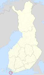
Hitis (Finnish: Hiittinen) is a small archipelago and a former municipality in Finland. It lies south from Kimitoön in the province of Southwest Finland.

The main islands of Hitis are Rosala and Hitis. They are connected to the mainland by a ferry. Totally there are over 2 000 islands and islets in Hitis, and some of them are still inhabited permanently. There are many summer cottages in Hitis.

Hitis was a trade harbour during the Viking era. Administratively it was part of Kimito until the municipality was established in 1861. During the World War II there were battles of Bengtskär and Morgonlandet in the area of Hitis. The municipality was merged to Dragsfjärd in 1969.

Villages

[edit]

Bergö, Biskopsö, Bolax, Böle, Hitis, Holma, Högsåra, Kaxskäla, Kasnäs, Rosala, Stubbnäs, Tunhamn, Vänoxa, Vänö

References

[edit]
  1. ^ a b c d "Area of Finnish Municipalities 1.1.2018" (PDF). National Land Survey of Finland. Retrieved 30 January 2018.
  • ^ Statistics of Hitis (in Finnish)
  • 59°53′N 22°31′E / 59.883°N 22.517°E / 59.883; 22.517


    Retrieved from "https://en.wikipedia.org/w/index.php?title=Hitis&oldid=1212895187"

    Categories: 
    Kimitoön
    Former municipalities of Finland
    1861 establishments in Finland
    Hidden categories: 
    Articles with Finnish-language sources (fi)
    Pages using gadget WikiMiniAtlas
    Articles with short description
    Short description is different from Wikidata
    Articles containing Swedish-language text
    Articles containing Finnish-language text
    Pages using infobox settlement with no coordinates
    Coordinates on Wikidata


    This page was last edited on 10 March 2024, at 02:21 (UTC).

    Text is available under the Creative Commons Attribution-ShareAlike License 4.0; additional terms may apply. By using this site, you agree to the Terms of Use and Privacy Policy. Wikipedia® is a registered trademark of the Wikimedia Foundation, Inc., a non-profit organization.


    Privacy policy

    About Wikipedia

    Disclaimers

    Contact Wikipedia

    Code of Conduct

    Developers

    Statistics

    Cookie statement

    Mobile view


    Wikimedia Foundation
    Powered by MediaWiki