Jump to content


Main menu


Navigation  


Main page
Contents
Current events
Random article
About Wikipedia
Contact us
Donate


Contribute  


Help
Learn to edit
Community portal
Recent changes
Upload file


Search  


Create account

Log in


Create account
 Log in


Pages for logged out editors learn more  


Contributions
Talk


Contents


(Top)


1 Location and geography  


2 History  


3 See also  


4 References  


Hogan Group


Cebuano
Deutsch
Svenska
 

Edit links


Article
Talk


Read
Edit
View history


Tools


Actions  


Read
Edit
View history


General  


What links here
Related changes
Upload file
Special pages
Permanent link
Page information
Cite this page
Get shortened URL
Download QR code
Wikidata item


Print/export  


Download as PDF
Printable version


Appearance


Coordinates: 39°15S 146°59E / 39.250°S 146.983°E / -39.250; 146.983
 

From Wikipedia, the free encyclopedia


Hogan Group
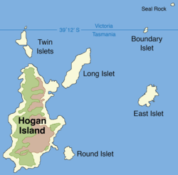
Map of the Hogan Group
Hogan Group is located in Tasmania
Hogan Group

Hogan Group

Location of Hogan Group in the Bass Strait, north of Tasmania

EtymologyMichael Hogan
Geography
LocationBass Strait
Coordinates39°15′S 146°59′E / 39.250°S 146.983°E / -39.250; 146.983
ArchipelagoHogan Group
Total islands6-8[1]
Major islandsHogan Island
Highest elevation130 m (430 ft)[2]
Administration

Australia

StateVictoria
StateTasmania

The Hogan Group is a collection of six (to eight[1]) islands and islets located in the Bass Strait that define part of the border between mainland Australia and the island state of Tasmania. Within the jurisdiction of Tasmania, the Hogan Group forms a land border between the states of Tasmania and Victoria. The island group is officially designated unallocated Crown land,[3] within the Flinders Municipality in Tasmania and the South Gippsland Shire in Victoria.

The Hogan Group comprises the Hogan Island, Twin, Long, Round, East, Boundary (or North East) islets, and Seal Rock.

Location and geography[edit]

The Hogan Group is located 40 kilometres (25 mi) southeast of Wilsons Promontory in the Bass Strait. The islands are made up of grey and red granite and limestone. A group of fur seals live on Boundary Islet. Other plants and animals that live on and near the island group include Cystophora intermedia, eelgrass, kelp, and abalone.[2]

History[edit]

During the Pleistocene period, the Hogan Group was part of a land bridge that connected Tasmania to mainland Australia. After the glacial period ended, the Hogan Group were the first group of islands to become isolated by rising sea levels.[1]

The Hogan Group was discovered by Europeans and named in 1801 by John Black, captain of the brig Harbinger, who named the island group after Michael Hogan, the owner of his ship. There are records of settlers on the island group, who hunted seals and kangaroos and used the islands for grazing land.[1] On 12 October 1900, the first lease was recorded and given for Hogan Island. While the original lease covered the entire island group, since 1959 the lease has only applied to Hogan Island, which has been leased by B.R. Stackhouse since 1967, who uses the island for sheep and cattle grazing.[1]

Black erred in his initial survey, placing the group further north than they actually are, which led to the Victoria-Tasmania land border on Boundary Islet.[4]

See also[edit]

  • iconIslands portal
  • iconEnvironment portal
  • References[edit]

    1. ^ a b c d e Hope, Jeannette; Brown, G.; McIntosh, B. S. (1973). "Natural History of the Hogan Group" (PDF). Papers and Proceedings of the Royal Society of Tasmania. 107. Royal Society of Tasmania. Retrieved 11 July 2014.
  • ^ a b "Bass Strait Islands". Marine Life Network. Retrieved 11 July 2014.
  • ^ "Tasmania's islands – land tenure and access issues" (PDF). July 2005. p. 6. Archived from the original (PDF) on 14 July 2014. Retrieved 11 July 2014.
  • ^ "Victoria - Tasmania border" (PDF). Archived from the original (PDF) on 14 July 2014. Retrieved 11 July 2014.

  • Retrieved from "https://en.wikipedia.org/w/index.php?title=Hogan_Group&oldid=1153608208"

    Categories: 
    Hogan Group
    Islands of North East Tasmania
    Islands of Bass Strait
    Islands of Victoria (state)
    Borders of Tasmania
    Borders of Victoria (state)
    Hidden categories: 
    Pages using gadget WikiMiniAtlas
    Articles with short description
    Short description matches Wikidata
    Use Australian English from May 2015
    All Wikipedia articles written in Australian English
    Use dmy dates from May 2015
    Coordinates on Wikidata


    This page was last edited on 7 May 2023, at 09:30 (UTC).

    Text is available under the Creative Commons Attribution-ShareAlike License 4.0; additional terms may apply. By using this site, you agree to the Terms of Use and Privacy Policy. Wikipedia® is a registered trademark of the Wikimedia Foundation, Inc., a non-profit organization.


    Privacy policy

    About Wikipedia

    Disclaimers

    Contact Wikipedia

    Code of Conduct

    Developers

    Statistics

    Cookie statement

    Mobile view


    Wikimedia Foundation
    Powered by MediaWiki