Jump to content


Main menu


Navigation  


Main page
Contents
Current events
Random article
About Wikipedia
Contact us
Donate


Contribute  


Help
Learn to edit
Community portal
Recent changes
Upload file


Search  


Create account

Log in


Create account
 Log in


Pages for logged out editors learn more  


Contributions
Talk


Contents


(Top)


1 District board  


2 Abolition  


3 References  


Holborn District (Metropolis)


Add links


Article
Talk


Read
Edit
View history


Tools


Actions  


Read
Edit
View history


General  


What links here
Related changes
Upload file
Special pages
Permanent link
Page information
Cite this page
Get shortened URL
Download QR code
Wikidata item


Print/export  


Download as PDF
Printable version


Appearance


From Wikipedia, the free encyclopedia


Holborn

Old Holborn Town Hall on Gray's Inn Road

Area
 • 1861167 acres (0.68 km2)[1]
 • 1871167 acres (0.68 km2)[1]
 • 1881167 acres (0.68 km2)[2]
 • 1891168 acres (0.68 km2)[3]
Population
 • 186145,463[1]
 • 187143,520[1]
 • 188136,189[2]
 • 189133,485[3]
History
 • Created1855
 • Abolished1900
 • Succeeded byMetropolitan Borough of Holborn
Metropolitan Borough of Finsbury
StatusDistrict
GovernmentHolborn District Board of Works
 • HQHolborn Town Hall, Gray's Inn Road.

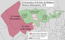
Holborn was a local government district in the metropolitan area of London to the north west of the City of London from 1855 to 1900.

The district was formed by the Metropolis Management Act 1855 from the following Middlesex civil parishes and places:[4]

District board

[edit]

The district was governed by the Holborn District Board of Works, which consisted of forty-nine elected vestrymen: twenty-four elected for the parish of St Andrew Holborn above Bars; nine for St George the Martyr; nine for Saffron Hill, Hatton Garden, Ely Rents, and Ely Place; six for St Sepulchre and one for Glasshouse Yard.[5] The first elections were held in November 1855, when the entire membership of the board was elected. Thereafter elections for one third of the seats were held in May, beginning in the year 1857.[6]

Holborn District was originally within the area of responsibility of the Metropolitan Board of Works and nominated one member to the MBW. In 1889 the area of the Metropolitan Board became the County of London, and Holborn District Board of Works became a local council under the London County Council.

The Board of Works was administered from the old Holborn Town Hall, Gray's Inn Road.[7]

Abolition

[edit]

The district was abolished in 1900, when the County of London was divided into twenty-eight metropolitan boroughs. A new Metropolitan Borough of Holborn was created by the merger of Holborn District (less Glasshouse Yard and St Sepulchre) with the neighbouring St Giles District along with two of the Inns of Court: Lincoln's Inn and Staple Inn.[8] Glasshouse Yard and St Sepulchre became part of the Metropolitan Borough of Finsbury.

References

[edit]
  1. ^ a b c d "Table 10. Area; inhabited houses, population, number of rated householders and rateable value of property within this district of the Metropolitan board of works". Census of England and Wales 1871 Population tables. Vol. II. Online Historical Population Reports (histpop.org). p. 31. Retrieved 4 August 2010.
  • ^ a b "Supplementary Metropolitan tables. Table b. Area, inhabited houses, and population, in 1871 and 1881, number of rated house-holders, and rateable annual value of property assessed in the several parishes, &c. Within the district of the Metropolitan board of works, as defined by 18 and 19 Vict. C. 120". Census of England and Wales 1881 Population tables. Vol. II. Online Historical Population Reports (histpop.org). 1882. p. 30. Retrieved 2 August 2010.
  • ^ a b "Division I: London. Table 4. Sanitary areas, distinguishing those under vestries, boards of works and other authorities". Census of England and Wales 1891. Vol II: Registration areas and sanitary districts. Online Historical Population Reports (histpop.org). 1893. p. 17. Retrieved 2 August 2010.
  • ^ Metropolis Management Act 1855 (18 & 19 Vict. c.120)
  • ^ Metropolis Management Act 1855 Schedule 2
  • ^ Metropolis Management Act 1855, ss.7-9
  • ^ Post Office London Directory, 1895, Part 3: Commercial and Professional Directory
  • ^ Frederic A Youngs Jr. Guide to the Local Administrative Units of England, Volume 1: Southern England, London , 1979

  • Retrieved from "https://en.wikipedia.org/w/index.php?title=Holborn_District_(Metropolis)&oldid=1084242980"

    Categories: 
    History of the London Borough of Camden
    Districts (Metropolis)
    Hidden categories: 
    Use dmy dates from April 2022
    Former country articles requiring maintenance
    London articles missing geocoordinate data
    All articles needing coordinates
    Articles missing coordinates without coordinates on Wikidata


    This page was last edited on 23 April 2022, at 10:39 (UTC).

    Text is available under the Creative Commons Attribution-ShareAlike License 4.0; additional terms may apply. By using this site, you agree to the Terms of Use and Privacy Policy. Wikipedia® is a registered trademark of the Wikimedia Foundation, Inc., a non-profit organization.


    Privacy policy

    About Wikipedia

    Disclaimers

    Contact Wikipedia

    Code of Conduct

    Developers

    Statistics

    Cookie statement

    Mobile view


    Wikimedia Foundation
    Powered by MediaWiki