Jump to content


Main menu


Navigation  


Main page
Contents
Current events
Random article
About Wikipedia
Contact us
Donate


Contribute  


Help
Learn to edit
Community portal
Recent changes
Upload file


Search  


Create account

Log in


Create account
 Log in


Pages for logged out editors learn more  


Contributions
Talk


Contents


(Top)


1 Park Information  


2 Gallery  


3 See also  


4 External links  


Holly Recreation Area


Add links


Article
Talk


Read
Edit
View history


Tools


Actions  


Read
Edit
View history


General  


What links here
Related changes
Upload file
Special pages
Permanent link
Page information
Cite this page
Get shortened URL
Download QR code
Wikidata item


Print/export  


Download as PDF
Printable version


Appearance


Coordinates: 42°4852N 83°3233W / 42.81444°N 83.5425°W / 42.81444; -83.5425
 

From Wikipedia, the free encyclopedia


Holly State Recreation Area
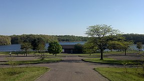
Heron Lake Beach Area
Map showing the location of Holly State Recreation Area

Location within the state of Michigan

Map showing the location of Holly State Recreation Area

Holly Recreation Area (the United States)

LocationLower Peninsula, Oakland County, Michigan USA
Nearest cityHolly, Michigan
Coordinates42°48′52N 83°32′33W / 42.81444°N 83.5425°W / 42.81444; -83.5425
Area7,817 acres (3,163 ha)
Governing bodyMichigan Department of Natural Resources
WebsiteOfficial website

Holly State Recreation Area is a state recreation area in Groveland Township, near Holly, Michigan.

Park Information

[edit]

Covering 7,817 acres (3,163 ha) of rolling woodland and open fields, the park area is bisected by Dixie Highway and Interstate 75, with a majority of park features to the east, and the Holdbridge Lakes Mountain Bike Area to the west, featuring the Gruber's Grinder trail. Features include an 18-hole disc golf course, 35 miles (56 km) of hiking and mountain biking trails, a model airplane flying field, opportunities for swimming, fishing, boating, and hunting. Winter activities include cross-country skiing and snowmobiling. Camping is provided for at 160 campsites and 3 rustic cabins, one of which is the Rolston Cabin. There is a groomed beach with picnic tables, a snack bar, and boat rentals on Heron Lake. The park area also encompasses McGinnis Lake, Valley Lake, and Wildwood Lake.

The park typically sees the highest number of visitors in August and September, coinciding with the Michigan Renaissance Festival, which is located near the park.

The area is managed by the Michigan Department of Natural Resources.

[edit]

See also

[edit]
[edit]


  • t
  • e
  • t
  • e

  • Retrieved from "https://en.wikipedia.org/w/index.php?title=Holly_Recreation_Area&oldid=1085903910"

    Categories: 
    Protected areas of Oakland County, Michigan
    State recreation areas of Michigan
    Southeast Michigan geography stubs
    Michigan geography stubs
    Midwestern United States protected area stubs
    Hidden categories: 
    Pages using gadget WikiMiniAtlas
    Coordinates on Wikidata
    All stub articles


    This page was last edited on 3 May 2022, at 02:05 (UTC).

    Text is available under the Creative Commons Attribution-ShareAlike License 4.0; additional terms may apply. By using this site, you agree to the Terms of Use and Privacy Policy. Wikipedia® is a registered trademark of the Wikimedia Foundation, Inc., a non-profit organization.


    Privacy policy

    About Wikipedia

    Disclaimers

    Contact Wikipedia

    Code of Conduct

    Developers

    Statistics

    Cookie statement

    Mobile view


    Wikimedia Foundation
    Powered by MediaWiki