Jump to content


Main menu


Navigation  


Main page
Contents
Current events
Random article
About Wikipedia
Contact us
Donate


Contribute  


Help
Learn to edit
Community portal
Recent changes
Upload file


Search  


Create account

Log in


Create account
 Log in


Pages for logged out editors learn more  


Contributions
Talk


Contents


(Top)


1 Geography  


2 Geology  


3 Fossils  


3.1  Stratigraphy  


4 References  


5 External links  


House Range


Cebuano
Français
Ladin
 

Edit links


Article
Talk


Read
Edit
View history


Tools


Actions  


Read
Edit
View history


General  


What links here
Related changes
Upload file
Special pages
Permanent link
Page information
Cite this page
Get shortened URL
Download QR code
Wikidata item


Print/export  


Download as PDF
Printable version


In other projects  


Wikimedia Commons


Appearance


Coordinates: 39°2317N 113°1859W / 39.388142°N 113.316408°W / 39.388142; -113.316408
 

From Wikipedia, the free encyclopedia


House Range
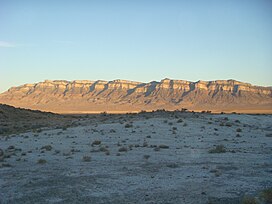
A photo of the northern part of the House Range at sunset
Northern part of the House Range at sunset-(Swasey Mountain section), showing the stratigraphy
Highest point
PeakSwasey Peak
Elevation9,669 ft (2,947 m)
Coordinates39°23′17N 113°18′59W / 39.388142°N 113.316408°W / 39.388142; -113.316408
Dimensions
Length70 mi (110 km) N/S
Width34 mi (55 km) E/W
Area1,242 sq mi (3,220 km2)
Geography
A map of Utah showing the location of the House Range

House Range

CountryUnited States
StateMillard County, Utah
"Spring Storm in the Great Basin" — House Range and Tule Valley.

The House Range is a north-south trending mountain rangeinMillard County, of west-central Utah. The House Range was named in 1859 by James H. Simpson. It was named by Simpson because "...of its well-defined stratification and the resemblance of portions of its outline to domes, minarets, houses, and other structures."[1]

Geography[edit]

The House Range is bounded by Tule Valley to the west, Whirlwind Valley and Sevier Desert to the east, and trends with the Fish Springs Range to the north. The range has three notable passes: Skull Rock Pass (which US Highway 6/US Highway 50 travels through), Marjum Canyon (which the old US Highway 6 travels through), and Sand Pass (which the Weiss Highway passes through).

The highest point in the House Range is Swasey Peak, at 9,669 feet (2,947 m).[2] Other notable peaks include Notch Peak, a frequent climbing and base-jumping hotspot, and the very square Tatow Knob.

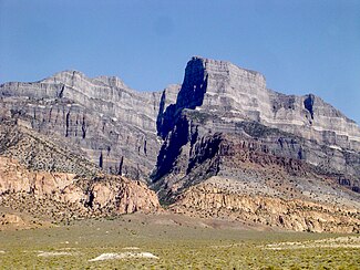
It is also known for one of the tallest limestone cliffs in the world, Notch Peak.

Geology[edit]

The geology of the House Range is dominated by gray CambriantoDevonian carbonate rock which was intruded by a pink Jurassic granitoid in the central part of the range. In the Wheeler Amphitheater, away from the intrusion, the Lagerstätte that contains the well-preserved fauna is found in the Cambrian section of the range. Evidence of Lake Bonneville's presence is found both in shorelines and white marls at the base of the range. The main structural component to the range is a large basin-bounding fault on the west side.[3]

Fossils[edit]

The range is known for a fossil Lagerstätte (Wheeler Shale) of Cambrian age, which has an array of Burgess Shale type fauna, including Elrathia kingii, a trilobite that is one of Utah's most famous fossils.[4][5]

Stratigraphy[edit]

The Swasey Limestone was deposited in the BathyuriscusElrathina zone (contemporaneous with the Burgess Shale). This is overlain in turn by the Bolaspidella zone (uppermost Middle Cambrian) Wheeler Shale and Marjum Formation, then the Cedaria zone (lowermost Upper Cambrian) Weeks Formation.[6][7]
References[edit]

  1. ^ Van Cott, J. W., 1990, Utah Place Names, ISBN 0-87480-345-4
  • ^ "Feature Detail Report for: Swasey Peak". USGS.
  • ^ Chronic, Halka (1990). Roadside Geology of Utah. ISBN 0-87842-228-5.
  • ^ "Localities of the Cambrian: The House Range UCMP".
  • ^ "House Range". Peakbagger.com. Retrieved January 13, 2013.
  • ^ Robison, R. A. (1964). "Upper Middle Cambrian Stratigraphy of Western Utah". Geological Society of America Bulletin. 75: 995–1010. doi:10.1130/0016-7606(1964)75[995:UMCSOW]2.0.CO;2. ISSN 0016-7606.
  • ^ "House Range Cambrian Stratigraphy". fossilmuseum.net. Retrieved 14 October 2013.
  • Notch Peak, a notable limestone cliff in the southern part of the House Range, Utah.
    Notch Peak, a notable limestone cliff in the southern part of the House Range, Utah.

    External links[edit]


    Retrieved from "https://en.wikipedia.org/w/index.php?title=House_Range&oldid=1155871614"

    Categories: 
    Mountain ranges of Utah
    Mountain ranges of the Great Basin
    Mountain ranges of Millard County, Utah
    Hidden categories: 
    Pages using gadget WikiMiniAtlas
    Articles with short description
    Short description is different from Wikidata
    Coordinates on Wikidata
    Commons category link is on Wikidata


    This page was last edited on 20 May 2023, at 03:37 (UTC).

    Text is available under the Creative Commons Attribution-ShareAlike License 4.0; additional terms may apply. By using this site, you agree to the Terms of Use and Privacy Policy. Wikipedia® is a registered trademark of the Wikimedia Foundation, Inc., a non-profit organization.


    Privacy policy

    About Wikipedia

    Disclaimers

    Contact Wikipedia

    Code of Conduct

    Developers

    Statistics

    Cookie statement

    Mobile view


    Wikimedia Foundation
    Powered by MediaWiki