Jump to content


Main menu


Navigation  


Main page
Contents
Current events
Random article
About Wikipedia
Contact us
Donate


Contribute  


Help
Learn to edit
Community portal
Recent changes
Upload file


Search  


Create account

Log in


Create account
 Log in


Pages for logged out editors learn more  


Contributions
Talk


Contents


(Top)


1 Etymology  


2 History  


3 References  


Hron


العربية
Azərbaycanca
Беларуская
Беларуская (тарашкевіца)
Български
Bosanski
Català
Cebuano
Čeština
Dansk
Deutsch
Eesti
Español
Esperanto
Euskara
فارسی
Français

Hornjoserbsce
Hrvatski
Italiano
עברית

Ladin
Latviešu
Lietuvių
Limburgs
Magyar

مصرى
Nederlands
Norsk bokmål
Norsk nynorsk
پنجابی
Polski
Português
Română
Русиньскый
Русский
Simple English
Slovenčina
Српски / srpski
Svenska
Українська


Edit links


Article
Talk


Read
Edit
View history


Tools


Actions  


Read
Edit
View history


General  


What links here
Related changes
Upload file
Special pages
Permanent link
Page information
Cite this page
Get shortened URL
Download QR code
Wikidata item


Print/export  


Download as PDF
Printable version


In other projects  


Wikimedia Commons


Appearance


Coordinates: 47°49N 18°45E / 47.817°N 18.750°E / 47.817; 18.750
 

From Wikipedia, the free encyclopedia


Hron
The Hron near Starý Tekov

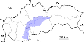
Current and watershed of the Hron River in Slovakia
Location
CountrySlovakia
RegionBanská Bystrica, Nitra
Physical characteristics
SourceHron
 • locationKráľova hoľa near Telgárt
 • elevation980 m (3,220 ft)
MouthDanube

 • location

Kamenica nad Hronom, Nitra Region

 • elevation

112 m (367 ft)
Length271 km (168 mi)
Basin size5,465 km2 (2,110 sq mi)
Discharge 
 • average53.7 m3/s (1,900 cu ft/s)
 • minimum7.6 m3/s (270 cu ft/s)
 • maximum1,050 m3/s (37,000 cu ft/s)
Basin features
ProgressionDanubeBlack Sea
Tributaries 
 • leftSlatina
 • rightZákruty

The Hron (Slovak: Hron; German: Gran; Hungarian: Garam; Latin: Granus) is a 271-kilometre (168 mi) long left tributary of the Danube[1] and the second-longest river in Slovakia. It flows from its source in the Low Tatra Mountains (below Kráľova hoľa) through central and southern Slovakia, emptying into the Danube near Štúrovo and Esztergom. Major cities and towns on the Hron are Brezno, Banská Bystrica, Sliač, Zvolen, Žiar nad Hronom, Žarnovica, Nová Baňa, Tlmače, Levice, Želiezovce, and Štúrovo.

The river's basin covers 5,465 km2 (2,110 sq mi),[1] which is approximately 11 percent of Slovakia's territory.

Hron is a popular destination of water tourism.

Etymology

[edit]

The name is probably of Germanic origin; *Granahua: gran – spruce, ahua – water.[2]

History

[edit]

The name of the river was mentioned for the first time in 170, when Roman Emperor Marcus Aurelius wrote his Meditations at the Hron (Latin: Granus) river.[3] The first recorded medieval name was Gron (1075).[3] From the 17th century until the 1930s, the river was used for wood transport.

References

[edit]
  • ^ Krško, Jaromír (2008). Hydronymia povodia Hrona (in Slovak). Banská Bystrica: Univerzita Mateja Bela. p. 81. ISBN 978-80-8083-611-5.
  • ^ a b Krško, Jaromír (June 2003). "Názvy potokov v Banskej Bystrici a okolí". Bystrický Permon. 1 (2): 8.
  • 47°49′N 18°45′E / 47.817°N 18.750°E / 47.817; 18.750


  • t
  • e

  • Retrieved from "https://en.wikipedia.org/w/index.php?title=Hron&oldid=1191590034"

    Categories: 
    Tributaries of the Danube
    Rivers of Slovakia
    Europe river stubs
    Slovakia geography stubs
    Hidden categories: 
    CS1 Slovak-language sources (sk)
    Pages using gadget WikiMiniAtlas
    Articles with short description
    Short description matches Wikidata
    Articles containing Slovak-language text
    Articles containing German-language text
    Articles containing Hungarian-language text
    Articles containing Latin-language text
    Commons category link is on Wikidata
    Articles with VIAF identifiers
    Articles with GND identifiers
    Articles with NKC identifiers
    Coordinates on Wikidata
    All stub articles


    This page was last edited on 24 December 2023, at 12:44 (UTC).

    Text is available under the Creative Commons Attribution-ShareAlike License 4.0; additional terms may apply. By using this site, you agree to the Terms of Use and Privacy Policy. Wikipedia® is a registered trademark of the Wikimedia Foundation, Inc., a non-profit organization.


    Privacy policy

    About Wikipedia

    Disclaimers

    Contact Wikipedia

    Code of Conduct

    Developers

    Statistics

    Cookie statement

    Mobile view


    Wikimedia Foundation
    Powered by MediaWiki