Jump to content


Main menu


Navigation  


Main page
Contents
Current events
Random article
About Wikipedia
Contact us
Donate


Contribute  


Help
Learn to edit
Community portal
Recent changes
Upload file


Search  


Create account

Log in


Create account
 Log in


Pages for logged out editors learn more  


Contributions
Talk


Contents


(Top)


1 See also  


2 References  


Hukeng, Fujian


Cebuano
Deutsch
فارسی
Русский
Svenska


Edit links


Article
Talk


Read
Edit
View history


Tools


Actions  


Read
Edit
View history


General  


What links here
Related changes
Upload file
Special pages
Permanent link
Page information
Cite this page
Get shortened URL
Download QR code
Wikidata item


Print/export  


Download as PDF
Printable version


In other projects  


Wikimedia Commons


Appearance


Coordinates: 24°3900N 116°5700E / 24.65000°N 116.95000°E / 24.65000; 116.95000
 

From Wikipedia, the free encyclopedia


Hukeng
湖坑鎮
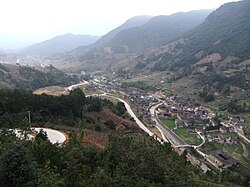
Nanjiang Village, a section of the "Great Wall of Tulou" in the Nanxi Valley
Hukeng is located in Fujian
Hukeng

Hukeng

Location in Fujian

Coordinates: 24°39′00N 116°57′00E / 24.65000°N 116.95000°E / 24.65000; 116.95000
CountryPeople's Republic of China
ProvinceFujian
Prefecture-level cityLongyan
CountyYongding
Area
 • Total95 km2 (37 sq mi)
Population
 (1997)
 • Total24,000
 http://www.xzqh.org/html/2008/1217/9544.html
Time zoneUTC+8 (China Standard)

Hukeng (Chinese: 湖坑) is a town (atownship-level division) situated in Yongding County, Longyan, Fujian, China.[1]

Hukeng town contains one of the Hakka settlements in China.[2] Moreover, a large number of Fujian Tulou are located with the territory administratively included within Hukeng, with a few within the actual Hukeng Town area. In particular, administratively, Hukeng includes the valley of the Nanxi (南溪, "South Creek"), where several villages (Yangduo, Xinnan, Nanzhong, Nanjiang, Shijia) consisting mostly of tulou form what some writers have dubbed the "Nanxi Great Wall of Tulou".

See also[edit]

References[edit]

  1. ^ "湖坑镇 (Hukeng Town)" (in Chinese). xzqh.org. Archived from the original on 2011-09-21. Retrieved 2012-05-24.
  • ^ Lin, Hsiao Hsien; Chen, I.-Yun; Lu, Shih-Yun; Tseng, Yi-Han; Lin, Jao-Chuan (1 January 2022). "Can cultural tourism resources become a development feature helping rural areas to revitalize the local economy under the epidemic? An exploration of the perspective of attractiveness, satisfaction, and willingness by the revisit of Hakka cultural tourism". Open Geosciences. 14 (1): 590–606. doi:10.1515/geo-2022-0358. ISSN 2391-5447.

  • t
  • e

  • Retrieved from "https://en.wikipedia.org/w/index.php?title=Hukeng,_Fujian&oldid=1136380025"

    Categories: 
    Township-level divisions of Fujian
    Longyan
    Fujian geography stubs
    Hidden categories: 
    Pages using gadget WikiMiniAtlas
    CS1 Chinese-language sources (zh)
    Articles with short description
    Short description is different from Wikidata
    Coordinates on Wikidata
    Articles containing Chinese-language text
    Commons category link is on Wikidata
    All stub articles


    This page was last edited on 30 January 2023, at 01:45 (UTC).

    Text is available under the Creative Commons Attribution-ShareAlike License 4.0; additional terms may apply. By using this site, you agree to the Terms of Use and Privacy Policy. Wikipedia® is a registered trademark of the Wikimedia Foundation, Inc., a non-profit organization.


    Privacy policy

    About Wikipedia

    Disclaimers

    Contact Wikipedia

    Code of Conduct

    Developers

    Statistics

    Cookie statement

    Mobile view


    Wikimedia Foundation
    Powered by MediaWiki