Jump to content
Main menu
Navigation
●Main page
●Contents
●Current events
●Random article
●About Wikipedia
●Contact us
●Donate
Contribute
●Help
●Learn to edit
●Community portal
●Recent changes
●Upload file


Search
●Create account
●Log in
●Create account
● Log in
Pages for logged out editors learn more
●Contributions
●Talk
Huon Gulf
●Brezhoneg
●Cebuano
●Čeština
●Deutsch
●Español
●Français
●Frysk
●Ilokano
●Bahasa Indonesia
●Italiano
●Кырык мары
●Lietuvių
●日本語
●Polski
●Português
●Русский
●中文
Edit links
●Article
●Talk
●Read
●Edit
●View history
Tools
Actions
●Read
●Edit
●View history
General
●What links here
●Related changes
●Upload file
●Special pages
●Permanent link
●Page information
●Cite this page
●Get shortened URL
●Download QR code
●Wikidata item
Print/export
●Download as PDF
●Printable version
Appearance
Coordinates: 7°00′S 147°27′E / 7.0°S 147.45°E / -7.0; 147.45
From Wikipedia, the free encyclopedia
Gulf of the Solomon Sea on the coast of New Guinea
Huon Gulf is a large gulf in eastern Papua New Guinea. It is bordered by Huon Peninsula in the north. Both are named after French explorer Jean-Michel Huon de Kermadec. Huon Gulf is a part of the Solomon Sea. Its northern boundary is marked by Cape Cretin, southern by Cape Longerue. The coast, which quickly increases in elevation from the beach, is bordered by the Rawlinson Range to the north and the Kuper Range to the west, which rises to about 600 m (2,000 ft). Lae, capital of the Morobe Province, is located on the northern coast of the gulf.
Markham Bay forms the north-western corner of Huon Gulf, where the Markham River ends.
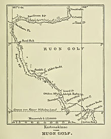 Map of Huon Gulf
t
e
Retrieved from "https://en.wikipedia.org/w/index.php?title=Huon_Gulf&oldid=1223030409"
Categories:
●Bodies of water of Papua New Guinea
●Gulfs of the Pacific Ocean
●Morobe Province
●Momase Region geography stubs
Hidden categories:
●Pages using gadget WikiMiniAtlas
●Articles lacking sources from December 2009
●All articles lacking sources
●Articles with short description
●Short description is different from Wikidata
●Coordinates on Wikidata
●Articles using infobox body of water without alt
●Articles using infobox body of water without pushpin map alt
●Articles using infobox body of water without image bathymetry
●Articles with VIAF identifiers
●Articles with GND identifiers
●All stub articles
●This page was last edited on 9 May 2024, at 13:04 (UTC).
●Text is available under the Creative Commons Attribution-ShareAlike License 4.0;
additional terms may apply. By using this site, you agree to the Terms of Use and Privacy Policy. Wikipedia® is a registered trademark of the Wikimedia Foundation, Inc., a non-profit organization.
●Privacy policy
●About Wikipedia
●Disclaimers
●Contact Wikipedia
●Code of Conduct
●Developers
●Statistics
●Cookie statement
●Mobile view


