

Map plotting the track and intensity of the storm, according to the Saffir–Simpson scale
| |
| Type | Tornado outbreak Tropical cyclone |
|---|---|
| Duration | October 3–4, 1964 |
| Tornadoes confirmed | 12 |
| Max. rating1 | F4 tornado |
| Duration of tornado outbreak2 | 1 day, 11 hours, 30 minutes |
| Fatalities | 22 fatalities, 175 injuries |
| Damage | ≥ $8.107 million (1964 USD)[1][nb 1] $79.6 million (2024 USD) |
| Areas affected | Southeastern United States |
Part of the tornadoes and tornado outbreaks of 1964 1Most severe tornado damage; see Fujita scale 2Time from first tornado to last tornado | |
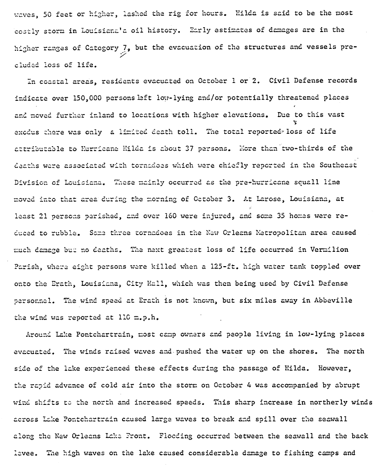
On October 3–4, 1964, Hurricane Hilda and its remnants generated a tornado outbreak over portions of the Southeastern United States. The outbreak, which yielded at least 12 confirmed tornadoes, killed 22 people and injured 175 others. Most of the casualties occurred as a result of a violent tornado that devastated the northern outskirts of Larose, Louisiana, becoming the deadliest hurricane-generated tornado on record since 1900 and one of only two violent tornadoes (F4+) recorded in the southern Gulf Coast region of Louisiana. The tornado was also one of only two F4s known to have been produced by a tropical cyclone, the other having occurred during Hurricane Carla on September 12, 1961.[2][3][4][nb 2][nb 3][nb 4]
At 23:00 UTC on October 3, 1964, Hurricane Hilda made landfallat29°30′N 91°30′W / 29.5°N 91.5°W / 29.5; -91.5, near Calumet, Louisiana, with maximum sustained winds of 105 mph (169 km/h) and an estimated atmospheric pressure of 959 mb (28.3 inHg).[14] Although Hilda extensively damaged portions of Louisiana, most of its severest impacts, including the vast majority of fatalities, were related to hurricane-spawned tornadoes, along with inland flooding.[15][16]
| Region | Locale | County | Deaths | Injuries | Damages | Source |
|---|---|---|---|---|---|---|
| United States | Alabama | Barbour | 0 | 3 | $2,500 | [1][17] |
| Butler | 0 | 0 | $25,000 | [1] | ||
| Conecuh | 0 | 0 | $2,500 | [1] | ||
| Louisiana | Assumption | 0 | 0 | $25,000 | [1] | |
| Jefferson | 0 | 3 | $2,500,000 | [1] | ||
| Lafourche | 22 | 165 | $2,527,500 | [1] | ||
| Orleans | 0 | 2 | $25,000 | [1] | ||
| St. Tammany | 0 | 0 | $2,500 | [1] | ||
| North Carolina | Unknown | 0 | 2 | $500,000 | [1][18] | |
| Total | 22 | 175 | $8,107,000 | [1] | ||
| FU | F0 | F1 | F2 | F3 | F4 | F5 | Total |
|---|---|---|---|---|---|---|---|
| 0 | 0 | 4 | 7 | 0 | 1 | 0 | 12 |
| F# | Location | County / Parish | State | Start coord. |
Time (UTC) | Path length | Max. width | Summary |
|---|---|---|---|---|---|---|---|---|
| F1 | Golden Meadow | Lafourche | LA | 29°22′N 90°14′W / 29.37°N 90.23°W / 29.37; -90.23 (Golden Meadow (October 3, F1)) | 11:45–? | 0.5 miles (0.80 km) | 33 yards (30 m) | A brief tornado downed utility wires and damaged several structures. Losses totaled $2,500.[20][21] |
| F1 | Galliano | Lafourche | LA | 29°26′N 90°17′W / 29.43°N 90.28°W / 29.43; -90.28 (Galliano (October 3, F1)) | 12:00–? | 0.5 miles (0.80 km) | 33 yards (30 m) | A short-lived tornado affected up to 10 homes and a funeral parlor. Several of the homes shifted on their CBS foundations or were overturned. Some boats were sunk and power lines downed as well. Losses totaled $25,000. Some minor injuries may have occurred.[22][21] |
| F4 | Northern Larose | Lafourche | LA | 29°36′N 90°22′W / 29.60°N 90.37°W / 29.60; -90.37 (Larose (October 3, F4)) | 12:30–? | 1.5 miles (2.4 km) | 67 yards (61 m) | 22 deaths – This devastating, violent tornado paralleled Highway 1 as it leveled a 1-mile-long (1.6 km) swath of homes. Only "shells" of brick homes remained in a few locations. Observers reported debris in Coteau, 16 mi (26 km) to the west of Larose. 165 people were injured and losses totaled $21⁄2 million. This was the deadliest hurricane-spawned tornado on record since 1900 and one of only two such tornadoes on record to have attained F4 intensity.[23][21][24][3][2] |
| F2 | New OrleanstoKenner | Orleans, Jefferson | LA | 29°56′N 90°13′W / 29.93°N 90.22°W / 29.93; -90.22 (Waggaman (October 3, F2)) | 15:00–15:20 | 14.2 miles (22.9 km) | 83 yards (76 m) | This possible tornado family initially damaged automobiles and structures in the French QuarterofNew Orleans. It then skipped to the intersection of the Veterans Highway and the Causeway, damaging gasoline stations and nearby buildings. Several vehicles, including a truck, were overturned or thrown into the air. Broken glass injured three people in Jefferson Parish and losses there totaled $21⁄2 million. Two other injuries and an additional $21⁄2 in losses occurred in Orleans Parish. At Kenner the tornado badly damaged 17 homes, several of which were unroofed. The NCEI indicates that the tornado developed north-northwest of Waggaman and ended near Seabrook.[25][26][21][24] |
| F2 | OakleytoAttakapas Canal | Assumption | LA | 29°55′N 91°06′W / 29.92°N 91.10°W / 29.92; -91.10 (Oakley (October 3, F2)) | 17:10–17:15 | 1.5 miles (2.4 km) | 100 yards (91 m) | This tornado tracked generally westward. It passed near Napoleonville, felling several trees. Homes and other structures shifted on their foundations or were unroofed. Losses totaled $25,000.[27][21][24] |
| F2 | White Sand to W of West Poplarville | Pearl River | MS | 30°48′N 89°39′W / 30.80°N 89.65°W / 30.80; -89.65 (White Sand (October 3, F2)) | 21:20–? | 3.3 miles (5.3 km) | 33 yards (30 m) | This strong tornado destroyed a pumphouse, a pair of barns, and a small house. Losses were unknown.[28][21][24] |
| F# | Location | County / Parish | State | Start coord. |
Time (UTC) | Path length | Max. width | Summary |
|---|---|---|---|---|---|---|---|---|
| F2 | WNW of Lewisburg | St. Tammany | LA | 30°23′N 90°08′W / 30.38°N 90.13°W / 30.38; -90.13 (Lewisburg (October 4, F2)) | 09:25–? | 1 mile (1.6 km) | 183 yards (167 m) | This tornado destroyed or damaged six lightweight homes. Debris was strewn over a 5-mile (8.0 km) area. Losses totaled $25,000.[29][17][24] |
| F1 | N of Flat Rock | Conecuh | AL | 31°30′N 86°50′W / 31.50°N 86.83°W / 31.50; -86.83 (Flat Rock (October 4, F1)) | 15:15–? | 0.1 miles (0.16 km) | 33 yards (30 m) | A tornado damaged several outbuildings and a few houses. Losses totaled $2,500.[30][17] |
| F1 | Northwestern Georgiana | Butler | AL | 31°38′N 86°46′W / 31.63°N 86.77°W / 31.63; -86.77 (Georgiana (October 4, F1)) | 16:20–? | 3.3 miles (5.3 km) | 100 yards (91 m) | A tornado unroofed, destroyed, or otherwise damaged 19 houses, many barns, and a fertilizer plant. Numerous trees were downed as well. Losses totaled $25,000. Tornado researcher Thomas P. Grazulis classified the tornado as an F2.[31][17][24] |
| F2 | NW of Williamston to SE of Alligator | Martin, Washington, Tyrrell | NC | 35°52′N 77°04′W / 35.87°N 77.07°W / 35.87; -77.07 (Williamston (October 4, F2)) | 20:30–21:30 | 54.1 miles (87.1 km) | 50 yards (46 m) | A possible tornado family severely damaged or destroyed outbuildings and five homes. It also moved heavy machinery for an unknown distance. Losses totaled $250,000. The publication Storm Data lists one injury.[32][18][24] |
| F2 | Western Eufaula | Barbour | AL | 31°48′N 85°12′W / 31.80°N 85.20°W / 31.80; -85.20 (Eufaula (October 4, F2)) | 21:00–? | 0.1 miles (0.16 km) | 33 yards (30 m) | A tornado affected buildings along Pump Station Road in Eufaula. It destroyed or damaged two houses, a factory, and a hospital. Three people were injured and losses totaled $2,500.[33][17] |
| F2 | NE of Cedar Grove to N of Penderlea | Columbus, Bladen, Pender | NC | 34°18′N 78°54′W / 34.30°N 78.90°W / 34.30; -78.90 (Cedar Grove (October 4, F2)) | 23:15–01:00 | 54.6 miles (87.9 km) | 50 yards (46 m) | This possible tornado family destroyed or damaged a trailer home, tobacco barns, various outbuildings, a few warehouses, and five homes. Losses totaled $250,000. The publication Storm Data lists one injury.[34][18] |