Jump to content


Main menu


Navigation  


Main page
Contents
Current events
Random article
About Wikipedia
Contact us
Donate


Contribute  


Help
Learn to edit
Community portal
Recent changes
Upload file


Search  


Create account

Log in


Create account
 Log in


Pages for logged out editors learn more  


Contributions
Talk


Contents


(Top)


1 Name  


2 See also  


3 References  


Hurrungane


Català
Cebuano
Dansk
Deutsch
Español
Français
Italiano
Ladin
Magyar
Nederlands
Norsk bokmål
Norsk nynorsk
Svenska


Edit links


Article
Talk


Read
Edit
View history


Tools


Actions  


Read
Edit
View history


General  


What links here
Related changes
Upload file
Special pages
Permanent link
Page information
Cite this page
Get shortened URL
Download QR code
Wikidata item


Print/export  


Download as PDF
Printable version


In other projects  


Wikimedia Commons


Appearance


Coordinates: 61°2741N 07°5217E / 61.46139°N 7.87139°E / 61.46139; 7.87139
 

From Wikipedia, the free encyclopedia


Hurrungane
Hurrungene, Hurrungadn, Horungane
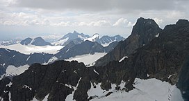
Hurrungane seen looking towards the west. Store Skagastølstind is the highest peak visible.
Highest point
PeakStore Skagastølstind, Luster/Årdal, Norway
Elevation2,405 m (7,890 ft)
Coordinates61°27′41N 07°52′17E / 61.46139°N 7.87139°E / 61.46139; 7.87139
Geography
Map of the location
Map of the location

Hurrungane

Location of the mountain

Map of the location
Map of the location

Hurrungane

Hurrungane (Norway)

LocationVestland, Norway
Range coordinates61°26′58N 7°50′36E / 61.4495°N 7.8434°E / 61.4495; 7.8434[1]
Parent rangeJotunheimen

Hurrungane (also written Hurrungene, Hurrungadn, Horungane) is a mountain range in the municipalities Luster and ÅrdalinVestland county, Norway. The area is southwest in the larger mountain range Jotunheimen and is also part of Jotunheimen National Park.[2]

The range has some of the most alpine peaks in Norway, and has 23 peaks over 2,000 metres (6,600 ft) (counting peaks with larger prominence than 30 metres or 98 feet). Several of the peaks are only accessible through climbingorglacier crossings. The starting point for hiking is the village of Turtagrø along the national tourist road, Sognefjellsvegen (RV55).

The highest peaks in the area are

Name[edit]

Hurrungane is the finite plural of a word hurrung. Hurrungen, the finite singular of the same word, is the names of two mountains in Rauma and Skjåk. The first element is the verb hurra which means "hurry, move fast (with noise and roar)". The last element is the suffix -ung, referring to an active thing/person. The actual mountains are steep, and there are frequent rockslides and avalanches from the hillsides. The meaning of the name is then "the noisemakers".[3]

The east face of Hurrungane as seen down Uradalen.

See also[edit]

References[edit]

  1. ^ "Hurrungane, Luster (Vestland)" (in Norwegian). yr.no. Retrieved 2020-01-07.[permanent dead link]
  • ^ Store norske leksikon. "Hurrungane" (in Norwegian). Retrieved 2010-09-10.
  • ^ Baxter, James (2005). Scandinavian Mountains and Peaks Over 2000 Metres in the Hurrungane. ISBN 978-0-9550497-0-5.

  • t
  • e

  • Retrieved from "https://en.wikipedia.org/w/index.php?title=Hurrungane&oldid=1155880068"

    Categories: 
    Mountain ranges of Norway
    Landforms of Vestland
    Jotunheimen
    Luster, Norway
    Årdal
    Vestland mountain stubs
    Hidden categories: 
    Pages using gadget WikiMiniAtlas
    CS1 Norwegian-language sources (no)
    All articles with dead external links
    Articles with dead external links from January 2023
    Articles with permanently dead external links
    Articles with short description
    Short description matches Wikidata
    Coordinates on Wikidata
    Commons category link from Wikidata
    Articles with VIAF identifiers
    All stub articles


    This page was last edited on 20 May 2023, at 04:39 (UTC).

    Text is available under the Creative Commons Attribution-ShareAlike License 4.0; additional terms may apply. By using this site, you agree to the Terms of Use and Privacy Policy. Wikipedia® is a registered trademark of the Wikimedia Foundation, Inc., a non-profit organization.


    Privacy policy

    About Wikipedia

    Disclaimers

    Contact Wikipedia

    Code of Conduct

    Developers

    Statistics

    Cookie statement

    Mobile view


    Wikimedia Foundation
    Powered by MediaWiki