Jump to content


Main menu


Navigation  


Main page
Contents
Current events
Random article
About Wikipedia
Contact us
Donate


Contribute  


Help
Learn to edit
Community portal
Recent changes
Upload file


Search  


Create account

Log in


Create account
 Log in


Pages for logged out editors learn more  


Contributions
Talk


Contents


(Top)


1 Background  


2 References  


3 External links  


Hyde Street Pier


Add links


Article
Talk


Read
Edit
View history


Tools


Actions  


Read
Edit
View history


General  


What links here
Related changes
Upload file
Special pages
Permanent link
Page information
Cite this page
Get shortened URL
Download QR code
Wikidata item


Print/export  


Download as PDF
Printable version


In other projects  


Wikimedia Commons


Appearance


Coordinates: 37°4832N 122°2516W / 37.80897°N 122.42117°W / 37.80897; -122.42117
 

From Wikipedia, the free encyclopedia


Hyde Street Pier

The Hyde Street Pier, at 2905 Hyde Street, is a historic ferry pier located on the northern waterfront of San Francisco in the U.S. state of California.[1]

Background[edit]

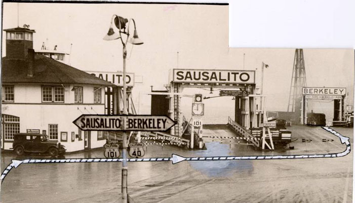
Prior to the opening of the Golden Gate Bridge and the San Francisco–Oakland Bay Bridge, it was the principal automobile ferry terminal connecting San Francisco with Marin County by way of Sausalito to the north, and the East Bay by way of Berkeley. It was designated part of U.S. Route 101 and U.S. Route 40. The ferries began operation by the Golden Gate Ferry Company. In early-1929, the Golden Gate Ferry Company merged with the competing auto ferry system of the Southern Pacific railroad, with ferry service to the Hyde Street Pier taken over by the new "Southern Pacific-Golden Gate Ferries, Ltd." starting on May 1, 1929.[2]

The pier is part of the San Francisco Maritime National Historical Park. Various historical ships are moored to the pier, some available for self-guided or docent-led tours. Among the ships on display or in storage are the Balclutha, an 1886 square rigged sailing ship, as well as C.A. Thayer, Eureka, Alma, Hercules, Eppleton Hall, and over one hundred smaller craft. In 2023, the Hōkūleʻa, a Polynesian double-hulled voyaging canoe, docked here as part of its Moananuiakea voyage, the circumnavigation of the Pacific Ocean.[3]

References[edit]

  1. ^ "The San Francisco Piers ... by the Numbers". FogCitySecrets.com. Retrieved August 1, 2019.
  • ^ Red Trains in the East Bay, by Robert Ford, pp.174-79, Interurbans Publications, 1977
  • ^ Richardson, Mahealani (October 2, 2023). "Hokulea's crew, supporters venture high above San Francisco to recall a common mission". Hawaii News Now. Retrieved October 3, 2023.
  • External links[edit]

    37°48′32N 122°25′16W / 37.80897°N 122.42117°W / 37.80897; -122.42117


    Retrieved from "https://en.wikipedia.org/w/index.php?title=Hyde_Street_Pier&oldid=1178586962"

    Categories: 
    Ferry terminals in the San Francisco Bay Area
    Piers in San Francisco
    Lincoln Highway
    Fisherman's Wharf, San Francisco
    U.S. Route 101
    U.S. Route 40
    Hidden categories: 
    Pages using gadget WikiMiniAtlas
    Use mdy dates from October 2023
    Commons category link from Wikidata
    Coordinates on Wikidata


    This page was last edited on 4 October 2023, at 16:22 (UTC).

    Text is available under the Creative Commons Attribution-ShareAlike License 4.0; additional terms may apply. By using this site, you agree to the Terms of Use and Privacy Policy. Wikipedia® is a registered trademark of the Wikimedia Foundation, Inc., a non-profit organization.


    Privacy policy

    About Wikipedia

    Disclaimers

    Contact Wikipedia

    Code of Conduct

    Developers

    Statistics

    Cookie statement

    Mobile view


    Wikimedia Foundation
    Powered by MediaWiki