Jump to content


Main menu


Navigation  


Main page
Contents
Current events
Random article
About Wikipedia
Contact us
Donate


Contribute  


Help
Learn to edit
Community portal
Recent changes
Upload file


Search  


Create account

Log in


Create account
 Log in


Pages for logged out editors learn more  


Contributions
Talk


Contents


(Top)


1 History  


2 Landmarks  


3 Notable people  


4 References  


5 External links  


Icklesham


Cebuano
Cymraeg
Deutsch
Español
فارسی
Français
Italiano
Ladin
Nederlands
Polski
Svenska
Türkçe
 

Edit links


Article
Talk


Read
Edit
View history


Tools


Actions  


Read
Edit
View history


General  


What links here
Related changes
Upload file
Special pages
Permanent link
Page information
Cite this page
Get shortened URL
Download QR code
Wikidata item


Print/export  


Download as PDF
Printable version


In other projects  


Wikimedia Commons


Appearance


Coordinates: 50°55N 0°40E / 50.92°N 0.67°E / 50.92; 0.67
 

From Wikipedia, the free encyclopedia


Icklesham

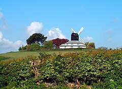
The windmill

Icklesham is located in East Sussex
Icklesham

Icklesham

Location within East Sussex

Area23.5 km2 (9.1 sq mi[1]
Population2,751 (Parish-2011)[2]
• Density309/sq mi (119/km2)
OS grid referenceTQ875162
• London53 miles (85 km) NW
Civil parish
District
Shire county
Region
CountryEngland
Sovereign stateUnited Kingdom
Post townWINCHELSEA
Postcode districtTN36
Dialling code01424
PoliceSussex
FireEast Sussex
AmbulanceSouth East Coast
UK Parliament
List of places
UK
England
East Sussex
50°55′N 0°40′E / 50.92°N 0.67°E / 50.92; 0.67

Icklesham is a village and civil parish in the Rother district of East Sussex, England. The village is located about six miles (10 km) east of Hastings, on the main A259 Hastings to Rye road. The surrounding countryside is a made up of fields, hills, woods, orchards and vineyards.[citation needed]

The civil parish is large, and includes Icklesham itself, Winchelsea, Winchelsea Beach and Rye Harbour.

History

[edit]

Icklesham's historic roots can be traced back to 772, when it appeared as Icoleshamme in a land charter signed by Offa, King of Mercia. Strategically located on the River Brede, it was a prime target in the Norman invasion of 1066 (some 700 years later, evacuation plans were prepared in case of an invasion by Napoleon).

The 12th Century church of All Saints & St. Nicholas was restoredbyarchitect Samuel Sanders Teulon in the late 1840s. The church was originally dedicated to All Saints in the Norman period but was changed by Henry VIII to St. Nicolas. Nicholas is associated with protecting mariners, appropriate as Icklesham was still coastal at the time. [4] [5]

Landmarks

[edit]

Hogg Hill Mill which overlooks the village, is used as a recording studio by Sir Paul McCartney.

A sandstone circle is located to the east of the parish church in a field by the main A259 road. It was constructed in approximately 2012.[6]

The parish contains three Sites of Special Scientific InterestWinchelsea Cutting, "Dungeness, Romney Marsh and Rye Bay" and Rye Harbour. Winchelsea Cutting is a 0.3-acre (0.12 ha) roadside cutting with 33 feet (10 m) of exposed geological strata.[7] Dungeness, Romney Marsh and Rye is a large site of 1,801 acres (729 ha), lying along the coast, and extending into the neighbouring county of Kent. Its interest is biological and geological, with various habitats of shingle, saltmarsh, sand dunes and saline lagoons.[8] Rye Harbour is another 1,881-acre (761 ha) site of biological importance, with a varied habitat of shingle, intertidal mudflats and saltmarsh.[9]

Notable people

[edit]

References

[edit]
  1. ^ "East Sussex in Figures". East Sussex County Council. Retrieved 26 April 2008.
  • ^ "Civil Parish population 2011". Retrieved 7 October 2015.
  • ^ "Icklesham Parish Council Website". Icklesham Parish Council. Retrieved 3 September 2021.
  • ^ Parish church Archived 2007-09-29 at the Wayback Machine
  • ^ "Benefice of Winchelsea and Icklesham". Retrieved 20 November 2021.
  • ^ "Archived copy" (PDF). Archived from the original (PDF) on 29 June 2014. Retrieved 14 September 2016.{{cite web}}: CS1 maint: archived copy as title (link)
  • ^ "Natural England - SSSI (Winchelsea Cutting)". English Nature. Retrieved 1 June 2008.
  • ^ "Natural England - SSSI (Dungeness, Romney Marsh and Rye)". English Nature. Retrieved 12 October 2008.
  • ^ "Natural England - SSSI (Rye Harbour)". English Nature. Retrieved 12 October 2008.
  • [edit]

    Media related to Icklesham at Wikimedia Commons


  • t
  • e

  • Retrieved from "https://en.wikipedia.org/w/index.php?title=Icklesham&oldid=1099418630"

    Categories: 
    Rother District
    Icklesham
    Villages in East Sussex
    Civil parishes in East Sussex
    East Sussex geography stubs
    Hidden categories: 
    Pages using gadget WikiMiniAtlas
    Webarchive template wayback links
    CS1 maint: archived copy as title
    Articles with short description
    Short description is different from Wikidata
    Use dmy dates from October 2019
    Articles with OS grid coordinates
    Coordinates on Wikidata
    All articles with unsourced statements
    Articles with unsourced statements from December 2021
    Commons category link is on Wikidata
    All stub articles


    This page was last edited on 20 July 2022, at 17:35 (UTC).

    Text is available under the Creative Commons Attribution-ShareAlike License 4.0; additional terms may apply. By using this site, you agree to the Terms of Use and Privacy Policy. Wikipedia® is a registered trademark of the Wikimedia Foundation, Inc., a non-profit organization.


    Privacy policy

    About Wikipedia

    Disclaimers

    Contact Wikipedia

    Code of Conduct

    Developers

    Statistics

    Cookie statement

    Mobile view


    Wikimedia Foundation
    Powered by MediaWiki