
Ilam
| |
|---|---|

Puaka-James Hight, home to the University of Canterbury Central Library and centrepiece of the University's Ilam campus.
| |
 | |
| Coordinates: 43°31′34″S 172°34′49″E / 43.526111°S 172.580278°E / -43.526111; 172.580278 | |
| Country | New Zealand |
| City | Christchurch |
| Local authority | Christchurch City Council |
| Electoral ward |
|
| Community board |
|
| Area | |
| • Land | 337 ha (833 acres) |
| Population
(June 2023)[2]
| |
| • Total | 9,930 |
| Burnside | Bryndwr | |
| Avonhead |
|
Fendalton |
| Upper Riccarton | Riccarton |
Ilam /ˈaɪləm/ is a suburb of Christchurch, New Zealand about five kilometres west of the city centre. It is the location of the University of Canterbury.
Located adjacent to State Highway 1 and the Christchurch International Airport, it is handily placed for transportation. It is also located close to the major retail area of Riccarton.

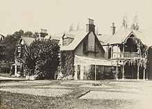
The suburb was named after the ancestral home of the Hon. John Watts-Russell (1825–75), who hailed from Ilam HallinStaffordshire, England. He settled in Canterbury in 1850, arriving on Sir George Seymour and named his property Ilam.[3] The Ilam homestead was in the 1950s inhabited by the rector of Canterbury College, Henry Rainsford Hulme. In 1954 the homestead gained notoriety as Hulme's 16-year-old daughter Juliet was involved in the Parker–Hulme murder case. The homestead was used as a major location for Peter Jackson's film about the murders, Heavenly Creatures. The homestead has been the University of Canterbury Staff Club since 1971.[4]
Ilam, comprising the statistical areas of Ilam North, Ilam South and Ilam University, covers 3.37 km2 (1.30 sq mi).[1] It had an estimated population of 9,930 as of June 2023, with a population density of 2,947 people per km2.
| Year | Pop. | ±% p.a. |
|---|---|---|
| 2006 | 8,532 | — |
| 2013 | 9,000 | +0.77% |
| 2018 | 9,357 | +0.78% |
| Source: [5] | ||
Ilam North had a population of 9,357 at the 2018 New Zealand census, an increase of 357 people (4.0%) since the 2013 census, and an increase of 825 people (9.7%) since the 2006 census. There were 2,628 households, comprising 4,881 males and 4,473 females, giving a sex ratio of 1.09 males per female, with 1,083 people (11.6%) aged under 15 years, 4,293 (45.9%) aged 15 to 29, 2,931 (31.3%) aged 30 to 64, and 1,053 (11.3%) aged 65 or older.
Ethnicities were 67.8% European/Pākehā, 5.9% Māori, 2.3% Pasifika, 28.5% Asian, and 3.2% other ethnicities. People may identify with more than one ethnicity.
The percentage of people born overseas was 37.8, compared with 27.1% nationally.
Although some people chose not to answer the census's question about religious affiliation, 51.2% had no religion, 35.3% were Christian, 0.1% had Māori religious beliefs, 1.9% were Hindu, 2.2% were Muslim, 1.8% were Buddhist and 2.6% had other religions.
Of those at least 15 years old, 2,352 (28.4%) people had a bachelor's or higher degree, and 507 (6.1%) people had no formal qualifications. 951 people (11.5%) earned over $70,000 compared to 17.2% nationally. The employment status of those at least 15 was that 2,790 (33.7%) people were employed full-time, 1,599 (19.3%) were part-time, and 468 (5.7%) were unemployed.[5]
| Name | Area (km2) |
Population | Density (per km2) |
Households | Median age | Median income |
|---|---|---|---|---|---|---|
| Ilam North | 1.23 | 3,729 | 3,032 | 1,218 | 30.3 years | $24,100[6] |
| Ilam South | 0.91 | 3,204 | 3,521 | 1,041 | 30.3 years | $22,900[7] |
| Ilam University | 1.23 | 2,424 | 1,971 | 369 | 20.2 years | $7,900[8] |
| New Zealand | 37.4 years | $31,800 |
Ilam Primary School, also located on Ilam Road, is a primary school situated next to the Canterbury University whose facilities the school uses. The school educates many children from overseas. It has a roll of 381.[9][10]
Westburn School is a state coeducational full primary school (years 1–8) with a roll of 408.[11] The school was founded in 1961.
Medbury School is a private full primary boys' school (years 1–8) with a roll of 379.[12] It was established in 1923.[13]
Rolls are as of February 2024.[14]
The Canterbury Japanese Supplementary School (カンタベリー日本語補習校 Kantaberī Nihongo Hoshūkō), a weekend Japanese school, holds its classes at the Ilam School in Ilam.[15]
|
| |||||||||||
|---|---|---|---|---|---|---|---|---|---|---|---|
| Populated places |
| ||||||||||
| Geographic features |
| ||||||||||
| Facilities and attractions |
| ||||||||||
| Government |
| ||||||||||