
Indramayu
| |
|---|---|
| Regional transcription(s) | |
| • Javanese | ꦆꦤ꧀ꦢꦿꦩꦪꦸ |

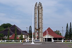
Bamboo Monument of Indramayu
| |
| Etymology: Sultant Wiralodra | |
|
Location in Java and Indonesia Show map of JavaIndramayu (Indonesia) Show map of Indonesia | |
| Coordinates: 6°21′10″S 108°19′27″E / 6.35278°S 108.32417°E / -6.35278; 108.32417 | |
| Country | |
| Province | West Java |
| Regency | Indramayu Regency |
| Government | |
| • Camat | Nandang Suparman |
| • Secretary | Rostati Kasman |
| Area | |
| • Total | 51.78 km2 (19.99 sq mi) |
| Elevation | 3 m (10 ft) |
| Population
(mid 2022 estimate)[2]
| |
| • Total | 122,400 |
| • Density | 2,400/km2 (6,100/sq mi) |
| Time zone | UTC+7 (IWT) |
| Postal code |
4521x
|
| Area code | (+62) 234 |
| Villages | 18 |
| Website | Official website |
Indramayu (Javanese: ꦆꦤ꧀ꦢꦿꦩꦪꦸ; Chinese: 南麻由), named after the God Indra, is a town and district which serves as the capital of Indramayu Regency in the West Java province of Indonesia, and is located in the northern coastal area of West Java, east from Jakarta, north-east from the city of Bandung, and north-west of the city of Cirebon. Most of its land are situated below sea level, which makes the district vulnerable to high tide in stormy conditions. The district is only protected by some dunes and barrages at the seaside.
Dermayu is the old name for Indramayu, in the form of the Dermayu Sultanate that was founded by Sultan Khalif Aria Wirasamudra in 1478 after gaining independence from the Majapahit empire. Sultan Marangali became the last Dermayu Sultan in 1770, after that the area fully came under colonial rule of the Dutch East India Company (VOC).[3]
Indramayu is divided into 18 villages which are as follows:[4] Eight of these are urban (kelurahan - indicated by #) and the other ten are rural desa.
Indramayu has a tropical savanna climate of Aw sub-type with moderate to little rainfall from May to November and heavy rainfall from December to April.
| Climate data for Indramayu | |||||||||||||
|---|---|---|---|---|---|---|---|---|---|---|---|---|---|
| Month | Jan | Feb | Mar | Apr | May | Jun | Jul | Aug | Sep | Oct | Nov | Dec | Year |
| Mean daily maximum °C (°F) | 30.8 (87.4) |
30.7 (87.3) |
31.2 (88.2) |
31.9 (89.4) |
32.4 (90.3) |
32.5 (90.5) |
32.9 (91.2) |
33.5 (92.3) |
34.2 (93.6) |
34.1 (93.4) |
33.0 (91.4) |
31.8 (89.2) |
32.4 (90.3) |
| Daily mean °C (°F) | 26.6 (79.9) |
26.6 (79.9) |
26.8 (80.2) |
27.3 (81.1) |
27.6 (81.7) |
27.3 (81.1) |
27.5 (81.5) |
27.7 (81.9) |
28.1 (82.6) |
28.1 (82.6) |
27.8 (82.0) |
27.1 (80.8) |
27.4 (81.3) |
| Mean daily minimum °C (°F) | 22.5 (72.5) |
22.5 (72.5) |
22.5 (72.5) |
22.7 (72.9) |
22.8 (73.0) |
22.2 (72.0) |
22.1 (71.8) |
21.9 (71.4) |
22.0 (71.6) |
22.2 (72.0) |
22.6 (72.7) |
22.5 (72.5) |
22.4 (72.3) |
| Average rainfall mm (inches) | 334 (13.1) |
285 (11.2) |
184 (7.2) |
150 (5.9) |
129 (5.1) |
97 (3.8) |
63 (2.5) |
28 (1.1) |
29 (1.1) |
64 (2.5) |
124 (4.9) |
209 (8.2) |
1,696 (66.6) |
| Source: Climate-Data.org[5] | |||||||||||||
The number of (registered) citizens of Indramayu Regency is about 1,851,000, but in the town itself just 120,866 people reside as at mid 2021.[6] The estimated land area of the town of Indramayu is 51.78 km2 (19.99 sq mi). The local population near the shore subside on fishing. Furthermore, kapok, cloves, citrus and other fruits are cultivated. Indramayu is famous for the special sweet mangosteens and is also known as one of mango producers in West Java. Indramayu was known as Indonesia's main rice supplier in the early 1980s to late 1990s.
98.8%[7] of the inhabitants are adherents of Islam, with the others being Protestant or Catholic Christians, Hindus, Buddhists, and Confucians.
Crude oil is found in the Indramayu area. Pertamina, the state's oil company, have operated a refinery just outside the town since 1994.[8]
That aside, because of an overall lack of industry and jobs, there is migration to other parts of Indonesia. In 2015, the unemployment in the town is 11.85% compared to a national average of 6.3% in 2016. Agriculture, trades, and services are the largest employers which altogether employed 73% of the workforce. The majority of "agricultural" workers are either rice farmers or fishermen, which employs about 5,000 workers each.[7]
This West Java location article is a stub. You can help Wikipedia by expanding it. |