Jump to content


Main menu


Navigation  


Main page
Contents
Current events
Random article
About Wikipedia
Contact us
Donate


Contribute  


Help
Learn to edit
Community portal
Recent changes
Upload file


Search  


Create account

Log in


Create account
 Log in


Pages for logged out editors learn more  


Contributions
Talk


Contents


(Top)


1 Location  


2 Amenities  


3 Governance  


4 In popular culture  


5 See also  


6 References  


7 External links  


Ireby, Cumbria


Cymraeg
Polski
 

Edit links


Article
Talk


Read
Edit
View history


Tools


Actions  


Read
Edit
View history


General  


What links here
Related changes
Upload file
Special pages
Permanent link
Page information
Cite this page
Get shortened URL
Download QR code
Wikidata item


Print/export  


Download as PDF
Printable version


In other projects  


Wikimedia Commons


Appearance


Coordinates: 54°4420N 3°1102W / 54.739°N 03.184°W / 54.739; -03.184
 

From Wikipedia, the free encyclopedia


Ireby
Village

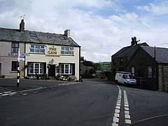
The Lion public house and crossroads, Ireby

Ireby is located in Cumbria
Ireby

Ireby

Location within Cumbria

OS grid referenceNY238390
Civil parish
Unitary authority
Ceremonial county
Region
CountryEngland
Sovereign stateUnited Kingdom
Post townWIGTON
Postcode districtCA7
Dialling code016973
PoliceCumbria
FireCumbria
AmbulanceNorth West
UK Parliament
List of places
UK
England
Cumbria
54°44′20N 3°11′02W / 54.739°N 03.184°W / 54.739; -03.184

Ireby is a village in Cumbria, England with a population of around 180.[1] Between 1974 and 2023, it was in Allerdale district, Cumbria. Since April 2023, it is administered by Cumberland Council.

It was granted a market charter in 1237.[2]

Location[edit]

It is located above the River Ellen, just outside the Lake District National Park, in the area locally called Back o'Skiddaw, with views to the Caldbeck Fells. The nearest towns are Wigton, 7 miles (11 km) away, and Cockermouth and Keswick, both 12 miles (19 km) away.

Nearby villages include Uldale, Torpenhow and Boltongate. Caldbeck is 6.1 miles (10 km) away.

Amenities[edit]

Ireby has two village halls, the main Globe Hall and the smaller Women's Institutes Hall.

Ireby has a music festival attracting a wide range of popular musicians and capacity audiences. In 2010, the Festival had Kate Rusby playing.[citation needed]

The village pub was reopened in 2016 after a long period of closure,[3] it was a haunt of John Peel.[citation needed]

Governance[edit]

Ireby is in the parliamentary constituencyofWorkington. In the December 2019 general election, the Tory candidate for Workington, Mark Jenkinson, was elected the MP, overturning a 9.4 per cent Labour majority from the 2017 election to eject shadow environment secretary Sue Hayman by a margin of 4,136 votes.[4] Until the December 2019 general election The Labour Party had won the seat in the constituency in every general election since 1979.The Conservative Party had only been elected once in Workington since World War II, at the 1976 by-election.[5]

Before Brexit, its residents were covered by the North West England European Parliamentary Constituency.

For Local Government purposes, it is in the Bothel and Wharrels WardofCumberland Council.

The village forms part of the civil parishofIreby and Uldale and has its own Parish Council along with Uldale, Ireby and Uldale Parish Council.[6][7]

In popular culture[edit]

A documentary series, Cumbrian Tales, was commissioned by the BBC in 1998, but taken off air after one episode due to "conflict of interest". The six-part series was eventually screened on ITV in 1999. [8][9]

See also[edit]

References[edit]

  1. ^ Ordnance Survey: Landranger map sheet 89 West Cumbria (Cockermouth & Wast Water) (Map). Ordnance Survey. 2011. ISBN 9780319232057.
  • ^ "Visit Cumbria: Ireby". www.visitcumbria.com. Retrieved 4 April 2016.
  • ^ "North Cumbrian village pub is hoping for a roaring success".
  • ^ "Workington parliamentary constituency – Election 2019".
  • ^ "A vision of Britain website – general elections section". Retrieved 27 April 2012.
  • ^ "Ordnance Survey Election Maps". www.ordnancesurvey.co.uk. Ordnance Survey. Retrieved 3 April 2016.
  • ^ "Ireby & Uldale Parish Council".
  • ^ "Opportunity Lost For Ireby". The Westmorland Gazette. Newsquest Media Group Ltd. 1 January 2000. Retrieved 18 December 2021.
  • ^ "IMDb: Cumbrian Tales". IMDb. Retrieved 18 December 2021.
  • External links[edit]


  • t
  • e

  • Retrieved from "https://en.wikipedia.org/w/index.php?title=Ireby,_Cumbria&oldid=1228484967"

    Categories: 
    Villages in Cumbria
    Allerdale
    Cumbria geography stubs
    Hidden categories: 
    Pages using gadget WikiMiniAtlas
    Use dmy dates from September 2019
    Use British English from September 2019
    Articles with short description
    Short description is different from Wikidata
    Articles with OS grid coordinates
    Coordinates on Wikidata
    All articles with unsourced statements
    Articles with unsourced statements from May 2020
    Commons category link is on Wikidata
    Articles with VIAF identifiers
    Articles with J9U identifiers
    Articles with LCCN identifiers
    All stub articles


    This page was last edited on 11 June 2024, at 13:58 (UTC).

    Text is available under the Creative Commons Attribution-ShareAlike License 4.0; additional terms may apply. By using this site, you agree to the Terms of Use and Privacy Policy. Wikipedia® is a registered trademark of the Wikimedia Foundation, Inc., a non-profit organization.


    Privacy policy

    About Wikipedia

    Disclaimers

    Contact Wikipedia

    Code of Conduct

    Developers

    Statistics

    Cookie statement

    Mobile view


    Wikimedia Foundation
    Powered by MediaWiki