Jump to content


Main menu


Navigation  


Main page
Contents
Current events
Random article
About Wikipedia
Contact us
Donate


Contribute  


Help
Learn to edit
Community portal
Recent changes
Upload file


Search  


Create account

Log in


Create account
 Log in


Pages for logged out editors learn more  


Contributions
Talk


Contents


(Top)


1 Course  


2 References  


3 Sources  


Iriri River


العربية
Asturianu
Azərbaycanca
Boarisch
Чӑвашла
Cebuano
Deutsch
Español
Français
Italiano
Lietuvių

مصرى
Nederlands

Norsk bokmål
Polski
Português
Русский
Srpskohrvatski / српскохрватски
Svenska
Українська
Tiếng Vit


Edit links


Article
Talk


Read
Edit
View history


Tools


Actions  


Read
Edit
View history


General  


What links here
Related changes
Upload file
Special pages
Permanent link
Page information
Cite this page
Get shortened URL
Download QR code
Wikidata item


Print/export  


Download as PDF
Printable version


In other projects  


Wikimedia Commons


Appearance


Coordinates: 3°4900S 52°3620W / 3.81667°S 52.60556°W / -3.81667; -52.60556
 

From Wikipedia, the free encyclopedia


Iriri River
Native name
  • Kororoti (Kayapó)[1]: 40 
  • Location
    CountryBrazil
    Physical characteristics
    Source 
     • locationPará, Brazil
     • elevation619 m (2,031 ft)
    MouthXingu River

     • coordinates

    3°49′00S 52°36′20W / 3.81667°S 52.60556°W / -3.81667; -52.60556

     • elevation

    116 m (381 ft)
    Length1,151 km (715 mi)[2]
    Basin size141,943 km2 (54,804 sq mi)[2]
    Discharge 
     • locationConfluence of Xingu (near mouth)
     • average3,028 m3/s (106,900 cu ft/s)[2]
     • minimum56.3 m3/s (1,990 cu ft/s)[2]
     • maximum14,025 m3/s (495,300 cu ft/s)[2]
    Discharge 
     • locationPedra do Ó gauge station (130 km upstream of mouth - Basin size 123,827 km2 (47,810 sq mi)
     • average2,748 m3/s (97,000 cu ft/s)[2]
     • minimum49 m3/s (1,700 cu ft/s)[2]
     • maximum12,235 m3/s (432,100 cu ft/s)[2]
    Basin features
    Tributaries 
     • leftCuruá River, Catete River, Chiché River, Ipiranga River
     • rightNovo River, Carajarí River, Xinxim River, Iriri Novo River

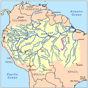
    The Iriri River (Portuguese: Rio Iriri, Portuguese pronunciation: [ˈʁiu iɾiˈɾi]; Mẽbêngôkre: Kororoti, [kɔˌɾɔɾɔˈti][1]: 40 ) is a large tributary of the Xingu RiverinBrazil, in the state of Pará. It is 1,300 km (810 mi) long making it the 116th longest river in the world (with Krishna River, India) and the 15th longest in the Amazon basin. The headwaters are the traditional home of the Panará people.

    Course

    [edit]

    The river rises in the 342,192-hectare (845,570-acre) Nascentes da Serra do Cachimbo Biological Reserve, a strictly protected conservation unit established in 2005 in the Serra do Cachimbo. It is one of the headwaters of the Xingu River.[3] It flows for 900 kilometres (560 mi) before joining the Xingu, running through the 3,373,133.89-hectare (8,335,195.4-acre) Terra do Meio Ecological Station. The river varies greatly in volume depending on the season, and in the dry season includes waterfalls, rocks and rapids.[4]

    The Iriri River flows through the Tapajós–Xingu moist forests ecoregion.[5] The river is rich in fish, including many species found only there and in the Xingu. Large sections remain unexplored due to its remoteness in a region surrounded by Amazon rainforest, and sections with strong current and cataracts.[6]

    References

    [edit]
    1. ^ a b Passos, João Lucas Moraes (2018). Caminhos mẽbêngôkre: andando, nomeando, sentando sobre a terra (Ph.D. thesis). Brasília: Universidade de Brasília.
  • ^ a b c d e f g h "Conhecimento Técnico e a regulação ambiental na Amazônia: A utilização da bacia hidrográfica nos EIA/RIMA das UHE do Rio Madeira e de Belo Monte". 2015.
  • ^ Unidade de Conservação: Reserva Biológica...
  • ^ Unidade de Conservação: Estação Ecológica ...
  • ^ Sears.
  • ^ Bleher 2009.
  • Sources

    [edit]
  • Sears, Robin, Amazon Basin - Brazil (NT0168), WWF: World Wildlife Fund, retrieved 2017-03-20
  • Unidade de Conservação: Estação Ecológica da Terra do Meio (in Portuguese), MMA: Ministério do Meio Ambiente, archived from the original on 2018-10-01, retrieved 2016-05-29
  • Unidade de Conservação: Reserva Biológica Nascentes Serra do Cachimbo (in Portuguese), MMA: Ministério do Meio Ambiente, retrieved 2016-05-27
  • Ziesler, R.; Ardizzone, G.D. (1979), "Amazon River System", The Inland waters of Latin America, Food and Agriculture Organization of the United Nations, ISBN 92-5-000780-9, archived from the original on 21 October 2013

  • t
  • e

  • Retrieved from "https://en.wikipedia.org/w/index.php?title=Iriri_River&oldid=1215948774"

    Categories: 
    Rivers of Pará
    Pará river stubs
    Hidden categories: 
    Pages using gadget WikiMiniAtlas
    Articles with short description
    Short description is different from Wikidata
    Articles containing Portuguese-language text
    Articles containing Kayapó-language text
    Coordinates on Wikidata
    Pages with Portuguese IPA
    Pages with plain IPA
    CS1 Portuguese-language sources (pt)
    All stub articles


    This page was last edited on 28 March 2024, at 03:17 (UTC).

    Text is available under the Creative Commons Attribution-ShareAlike License 4.0; additional terms may apply. By using this site, you agree to the Terms of Use and Privacy Policy. Wikipedia® is a registered trademark of the Wikimedia Foundation, Inc., a non-profit organization.


    Privacy policy

    About Wikipedia

    Disclaimers

    Contact Wikipedia

    Code of Conduct

    Developers

    Statistics

    Cookie statement

    Mobile view


    Wikimedia Foundation
    Powered by MediaWiki