Jump to content


Main menu


Navigation  


Main page
Contents
Current events
Random article
About Wikipedia
Contact us
Donate


Contribute  


Help
Learn to edit
Community portal
Recent changes
Upload file


Search  


Create account

Log in


Create account
 Log in


Pages for logged out editors learn more  


Contributions
Talk


Contents


(Top)


1 Amalgamation  


2 Composition and election method  


3 References  


Jerilderie Shire


Cebuano
Deutsch
Français
Italiano
Nederlands
Svenska
 

Edit links


Article
Talk


Read
Edit
View history


Tools


Actions  


Read
Edit
View history


General  


What links here
Related changes
Upload file
Special pages
Permanent link
Page information
Cite this page
Get shortened URL
Download QR code
Wikidata item


Print/export  


Download as PDF
Printable version


Appearance


Coordinates: 35°21S 145°44E / 35.350°S 145.733°E / -35.350; 145.733
 

From Wikipedia, the free encyclopedia


Jerilderie Shire
New South Wales
Jerilderie Shire Council office and chambers.
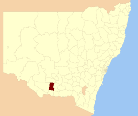
Location of Jerilderie Shire in New South Wales
Coordinates35°21′S 145°44′E / 35.350°S 145.733°E / -35.350; 145.733
Population1,526 (2012)[1]
 • Density0.45242/km2 (1.1718/sq mi)
Established1918
Abolished2016
Area3,373 km2 (1,302.3 sq mi)
Council seatJerilderie[2]
RegionMurray
State electorate(s)Albury
Federal division(s)Farrer
LGAs around Jerilderie Shire:
Murrumbidgee Murrumbidgee Narrandera
Conargo Jerilderie Shire Urana
Conargo Berrigan Corowa

Jerilderie Shire was a local government area in the Murray region of southern New South Wales, Australia. The Shire was located adjacent to the Newell Highway. The Shire was declared in 1918 after the amalgamation of the former Municipality of Jerilderie (1889 – 1918) and Wunnamurra Shire (1906 – 1918). It was dissolved in 2016 after its amalgamation with Murrumbidgee Shire to create Murrumbidgee Council

At the time of dissolution, Jerilderie Shire was the second smallest local government area in New South Wales, in terms of population.[citation needed]

The final mayor of Jerilderie Shire was Cr. Ruth McRae, an unaligned politician. The seat of the council was located in Jerilderie, the only significant town in the Shire.

Amalgamation

[edit]

A2015 review of local government boundaries by the NSW Government Independent Pricing and Regulatory Tribunal recommended that the Jerilderie Shire merge adjoining councils. The government considered three proposals. The first proposal was a merger between parts of the Jerilderie Shire with the Murrumbidgee Shire to form a new council with an area of 4,924 square kilometres (1,901 sq mi) and support a population of approximately 3,000.[3] The second proposal was a merger between the remaining parts of the Jerilderie Shire with the Berrigan Shire to form a new council with an area of 4,022 square kilometres (1,553 sq mi) and support a population of approximately 10,000.[4] The Jerilderie Shire Council submitted an alternate proposal to the Minister for Local Government that the entire Jerilderie Shire amalgamate with the Murrumbidgee Shire.[5]

Jerilderie Shire was dissolved on 12 May 2016 with the area, along with Murrumbidgee Shire, incorporated into the new Murrumbidgee Council.[6]

Composition and election method

[edit]

At the time of dissolution, Jerilderie Shire Council was composed of seven councillors elected proportionally as one entire ward. All councillors were elected for a fixed four-year term of office. The mayor was elected by the councillors at the first meeting of the council. The final election was held on 8 September 2012.

References

[edit]
  1. ^ "3218.0 - Regional Population Growth, Australia, 2012". Australian Bureau of Statistics. 30 August 2013. Retrieved 27 March 2014. Estimated resident population (ERP) at 30 June 2012.
  • ^ "Jerilderie Shire Council". Department of Local Government. Archived from the original on 6 September 2006. Retrieved 1 December 2006.
  • ^ "Merger proposal: Murrumbidgee Shire Council, Jerilderie Shire Council (part)" (PDF). Government of New South Wales. January 2016. p. 8. Retrieved 13 March 2016.
  • ^ "Merger proposal: Berrigan Shire Council, Jerilderie Shire Council (part)" (PDF). Government of New South Wales. January 2016. p. 8. Retrieved 13 March 2016.
  • ^ Jerilderie Shire Council (26 January 2016). "Merger proposal: Jerilderie Shire Council and Murrumbidgee Shire Council" (PDF). Council Boundary Review. Government of New South Wales. Retrieved 13 March 2016.
  • ^ "Murrumbidgee Council". Stronger Councils. Government of New South Wales. 12 May 2016. Retrieved 13 May 2016.

  • Retrieved from "https://en.wikipedia.org/w/index.php?title=Jerilderie_Shire&oldid=1215988163"

    Categories: 
    Populated places established in 1918
    1918 establishments in Australia
    Former local government areas of New South Wales
    2016 disestablishments in Australia
    Hidden categories: 
    Pages using gadget WikiMiniAtlas
    Articles with short description
    Short description matches Wikidata
    Use dmy dates from October 2021
    Use Australian English from September 2012
    All Wikipedia articles written in Australian English
    Coordinates on Wikidata
    Pages using infobox Australian place with an implicitly suppressed location map
    All articles with unsourced statements
    Articles with unsourced statements from September 2012
    Articles with VIAF identifiers
    Articles with WorldCat Entities identifiers
    Articles with LCCN identifiers


    This page was last edited on 28 March 2024, at 11:08 (UTC).

    Text is available under the Creative Commons Attribution-ShareAlike License 4.0; additional terms may apply. By using this site, you agree to the Terms of Use and Privacy Policy. Wikipedia® is a registered trademark of the Wikimedia Foundation, Inc., a non-profit organization.


    Privacy policy

    About Wikipedia

    Disclaimers

    Contact Wikipedia

    Code of Conduct

    Developers

    Statistics

    Cookie statement

    Mobile view


    Wikimedia Foundation
    Powered by MediaWiki