Jump to content


Main menu


Navigation  


Main page
Contents
Current events
Random article
About Wikipedia
Contact us
Donate


Contribute  


Help
Learn to edit
Community portal
Recent changes
Upload file


Search  


Create account

Log in


Create account
 Log in


Pages for logged out editors learn more  


Contributions
Talk


Contents


(Top)


1 Geography  


2 Division  


3 The people  


4 Places of interest  


5 See also  


6 References  


7 External links  


Jesús de Machaca Municipality


 / Bân-lâm-gú
Deutsch
Español
Italiano
Nederlands
Runa Simi
 

Edit links


Article
Talk


Read
Edit
View history


Tools


Actions  


Read
Edit
View history


General  


What links here
Related changes
Upload file
Special pages
Permanent link
Page information
Cite this page
Get shortened URL
Download QR code
Wikidata item


Print/export  


Download as PDF
Printable version


In other projects  


Wikimedia Commons


Appearance


Coordinates: 16°450S 68°450W / 16.75000°S 68.75000°W / -16.75000; -68.75000
 

From Wikipedia, the free encyclopedia


Jesús de Machaca Municipality
Municipality
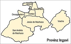
Location of the municipality within Ingavi province
Jesús de Machaca Municipality is located in Bolivia
Jesús de Machaca Municipality

Jesús de Machaca Municipality

Location of the Jesús de Machaca Municipality within Bolivia

Coordinates: 16°45′0″S 68°45′0″W / 16.75000°S 68.75000°W / -16.75000; -68.75000
Country Bolivia
DepartmentLa Paz Department
ProvinceIngavi Province
SeatJesús de Machaca
Government
 • MayorAdrian Aspi Cosme (2008)
 • PresidentMelicio Llanqui Mita (2008)
Area
 • Total369 sq mi (955 km2)
Population
 (2001)
 • Total13,247
Time zoneUTC-4 (BOT)

Jesús de Machaca Municipality is the sixth municipal section of the Ingavi Province in the La Paz DepartmentinBolivia. It was created by Law No. 2351 on May 7, 2002, during the presidency of Jorge Quiroga Ramírez.[1] Its seat is Jesús de Machaca.

Geography[edit]

Jesús de Machaca lies south of Lake Titicaca. The Chilla-Kimsa Chata mountain range traverses the municipality. Some of the highest mountains of the municipality are listed below:[2][3][4]

  • Apachita
  • Asir Kunka
  • Chuqi Ch'iwani
  • Chuqi Q'awa
  • Chuqi Q'awa (Chuñuni Jawira)
  • Chhuxlla Willk'i
  • Ch'alla Qullu
  • Ch'utu Wankarani
  • Imill Wawani
  • Jach'a Uma Chuwani
  • Jani Lawani
  • Jisk'a Sallalla
  • Laqaya
  • Pukara
  • Phujtir Pata Punta
  • Q'awiri Qullu
  • Q'ilani
  • Q'ullq'uni
  • Turini
  • T'aqachiri
  • Wayllani
  • Wanq'uni
  • Wila Qullu
  • Wisk'achani
  • Division[edit]

    The municipality consists of the following ten cantons:[5]

    The people[edit]

    The people are predominantly indigenous citizens of Aymara descent.[6]

    Ethnic group %
    Quechua 0.3
    Aymara 94.4
    Guaraní, Chiquitos, Moxos 0.1
    Not indigenous 4.3
    Other indigenous groups 0.9

    Places of interest[edit]

    Some of the tourist attractions of the municipality are:[7]

    See also[edit]

    References[edit]

  • ^ IGM map 1:50,000 5844-III Guaqui
  • ^ IGM map 1:50,000 5843-I Sacacani
  • ^ IGM map 1:50,000 Tiahuanacu 5844-II
  • ^ National Institute of Statistics of Bolivia Archived 2011-09-24 at the Wayback Machine
  • ^ obd.descentralizacion.gov.bo/municipal/fichas/ (inactive)
  • ^ www.gobernacionlapaz.gob.bo Archived 2011-05-09 at the Wayback Machine Tourist guide by the government of the department
  • External links[edit]

  • t
  • e

  • Retrieved from "https://en.wikipedia.org/w/index.php?title=Jesús_de_Machaca_Municipality&oldid=1010226274"

    Categories: 
    La Paz Department (Bolivia) geography stubs
    Municipalities of La Paz Department (Bolivia)
    Hidden categories: 
    Pages using gadget WikiMiniAtlas
    Webarchive template wayback links
    Articles with short description
    Short description is different from Wikidata
    Coordinates on Wikidata
    All articles with dead external links
    Articles with dead external links from February 2020
    Articles with permanently dead external links
    All stub articles


    This page was last edited on 4 March 2021, at 12:22 (UTC).

    Text is available under the Creative Commons Attribution-ShareAlike License 4.0; additional terms may apply. By using this site, you agree to the Terms of Use and Privacy Policy. Wikipedia® is a registered trademark of the Wikimedia Foundation, Inc., a non-profit organization.


    Privacy policy

    About Wikipedia

    Disclaimers

    Contact Wikipedia

    Code of Conduct

    Developers

    Statistics

    Cookie statement

    Mobile view


    Wikimedia Foundation
    Powered by MediaWiki