Jump to content


Main menu


Navigation  


Main page
Contents
Current events
Random article
About Wikipedia
Contact us
Donate


Contribute  


Help
Learn to edit
Community portal
Recent changes
Upload file


Search  


Create account

Log in


Create account
 Log in


Pages for logged out editors learn more  


Contributions
Talk


Contents


(Top)


1 Description  


2 History  


3 References  


Jisr Isdud


العربية
Čeština
Deutsch
עברית
Polski
 

Edit links


Article
Talk


Read
Edit
View history


Tools


Actions  


Read
Edit
View history


General  


What links here
Related changes
Upload file
Special pages
Permanent link
Page information
Cite this page
Get shortened URL
Download QR code
Wikidata item


Print/export  


Download as PDF
Printable version


In other projects  


Wikimedia Commons


Appearance


Coordinates: 31°4600N 34°3958E / 31.76667°N 34.66611°E / 31.76667; 34.66611
 

From Wikipedia, the free encyclopedia


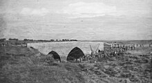
Jisr Isdud in 1917
The reconstructed bridge in 2016
Jisr Isdud in 1930, and its parallel railway bridge, in a Survey of Palestine map
Ad Halom Bridge (Jisr Isdud), restored section of Mamluk bridge, 2005, prior to its archaeological restoration
Sign in the area with the bridge shown bottom right

Jisr IsdudorIsdud Bridge, also known as the Ad Halom Bridge,[1][2] was a 13th century Mamluk bridge built over the Lakhish River (Wadi Sukrir/Wadi Fakhira).[2] It is located approximately 1.5 km north of the Ad Halom junction.[1] The bridge is similar in style and history to the nearby Jisr Jindas and Yibna Bridge.[3]

The bridge is used today by pedestrians and cyclists.[3]

Description[edit]

It is made of dressed kurkar stones, with three lancet arches. According to the Archaeological Survey of Israel, the south arch "reveals earlier masonry work, perhaps from the Mamluk period, if not earlier. Flooding in the wadi exposed remains of ancient buildings, built of dressed kurkar stones, near the NW section of the bridge."[1]

History[edit]

The bridge was a tactical location in the 1917 Battle of Mughar Ridge. It was blown up in 1946 by the Haganah in the Night of the Bridges, and again in 1948 by the Golani Brigade in early stages of the 1948 Arab–Israeli War.[3]

It was subsequently reconstructed and upgraded, and carried heavy traffic for many years. In 2010 it was upgraded with archaeological support led by preservation architect Saadia Mendel. The concrete middle arch was dismantles and rebuilt using Mamluk-era techniques.[3]

References[edit]

  1. ^ a b c "Jisr Isdud". antiquities.org.il. Retrieved 2022-12-27.
  • ^ a b Petersen, A. (2008): Bridges in Medieval Palestine, in U. Vermeulen & K. Dhulster (eds.), History of Egypt & Syria in the Fatimid, Ayyubid & Mamluk Eras V, V. Peeters, Leuven
  • ^ a b c d Dvir, Noam (2010-03-10). "Ancient Ashdod Bridge Restored to Former Glory". Haaretz.com. Retrieved 2023-01-07. The Ad Halom interchange south of Ashdod is known to most Israelis for its heavy traffic jams twice a day…. The Mamluks… established… three stone bridges surviving until today: near Yavneh, near the northern entrance to Lod, and the Ad Halom bridge over the Lachish stream. The three were built from local sandstone and have the same design - three pointed arches with the central one slightly taller than the other two… In June 1946, it was blown up by the Palmach during the "Night of the Bridges". Two years later, in the War of Independence, the bridge was blown up again, by a Golani Brigade unit, to stop the Egyptian army's advance… The operation's success led to the renaming of the bridge from "Gisser Asdud" (Ashdod Bridge) to "Ad Halom" (up to this stage). After the war, the bridge was restored without any attention to its historic significance and without any attempt to preserve the ancient stonework. For years, it carried heavy motorized traffic, until being replaced a few years ago by a modern interchange. The road company decided to use the opportunity to restore it again, this time in accordance with strict preservation codes. The Antiquities Authority dismantled the concrete middle arch, and rebuilt the bridge using the same technique as the Mamluks. The project was led by veteran preservation architect Saadia Mendel… The bridge will now be used by pedestrians and cyclists.
  • 31°46′00N 34°39′58E / 31.76667°N 34.66611°E / 31.76667; 34.66611


    Retrieved from "https://en.wikipedia.org/w/index.php?title=Jisr_Isdud&oldid=1219906995"

    Categories: 
    Bridges in Israel
    Buildings and structures in Ashdod
    Mamluk architecture in Israel
    Bridges completed in the 13th century
    Hidden categories: 
    Pages using gadget WikiMiniAtlas
    Coordinates on Wikidata


    This page was last edited on 20 April 2024, at 15:56 (UTC).

    Text is available under the Creative Commons Attribution-ShareAlike License 4.0; additional terms may apply. By using this site, you agree to the Terms of Use and Privacy Policy. Wikipedia® is a registered trademark of the Wikimedia Foundation, Inc., a non-profit organization.


    Privacy policy

    About Wikipedia

    Disclaimers

    Contact Wikipedia

    Code of Conduct

    Developers

    Statistics

    Cookie statement

    Mobile view


    Wikimedia Foundation
    Powered by MediaWiki