Jump to content


Main menu


Navigation  


Main page
Contents
Current events
Random article
About Wikipedia
Contact us
Donate


Contribute  


Help
Learn to edit
Community portal
Recent changes
Upload file


Search  


Create account

Log in


Create account
 Log in


Pages for logged out editors learn more  


Contributions
Talk


Contents


(Top)


1 History  


2 Geography  


3 See also  


4 References  


5 Further reading  


6 External links  


Jostedal Glacier


Беларуская
Català
Cebuano
Čeština
Dansk
Davvisámegiella
Deutsch
Eesti
Español
Esperanto
Français
Հայերեն
Hrvatski
Íslenska
Italiano
עברית
Lëtzebuergesch
Lietuvių
Magyar
Македонски
Nederlands

Norsk bokmål
Norsk nynorsk
Polski
Português
Русский
Slovenčina
Slovenščina
Srpskohrvatski / српскохрватски
Suomi
Svenska
Türkçe
Українська
 

Edit links


Article
Talk


Read
Edit
View history


Tools


Actions  


Read
Edit
View history


General  


What links here
Related changes
Upload file
Special pages
Permanent link
Page information
Cite this page
Get shortened URL
Download QR code
Wikidata item


Print/export  


Download as PDF
Printable version


In other projects  


Wikimedia Commons
Wikivoyage


Appearance


Coordinates: 61°4238N 06°5527E / 61.71056°N 6.92417°E / 61.71056; 6.92417
 

From Wikipedia, the free encyclopedia


Jostedal Glacier
Jostedalsbreen
View of the Jostedalsbreen glacier
Map showing the location of Jostedal Glacier

Glacier Location

Map showing the location of Jostedal Glacier

Jostedal Glacier (Norway)

TypeMountain glacier
LocationVestland, Norway
Coordinates61°42′38N 06°55′27E / 61.71056°N 6.92417°E / 61.71056; 6.92417
Area487 km2 (188 sq mi)
Length60 km (37 mi)
Thickness600 m (2,000 ft)

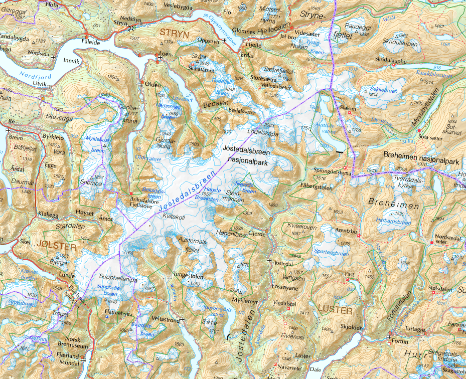
Jostedal GlacierorJostedalsbreen (Norwegian) is the largest glacier in continental Europe. It is in Vestland county in Western Norway.[1] Jostedalsbreen lies in the municipalities of Luster, Sogndal, Sunnfjord, and Stryn. The highest peak in the area is Lodalskåpa at a height of 2,083 metres (6,834 ft).

History[edit]

In 1906, work was being done on footpaths that could accommodate tourists.[2]

The glacial water is also used in distilling Vikingfjord

Geography[edit]

The Jostedal Glacier has a total area of 487 square kilometres (188 sq mi). The highest point is Høgste Breakulen at 1,957 metres (6,421 ft) above mean sea level. Branches of the glacier reach down into the valleys, for instance BøyabreeninFjærland and Nigardsbreen, both at 300 metres (980 ft) above sea level. The thickest part of the glacier is 600 metres (2,000 ft). Jostedalsbreen has a length of a little more than 60 kilometres (37 mi) and it is a part of the 1,310-square-kilometre (510 sq mi) Jostedalsbreen National Park, which was established in 1991. The glacier covers over half of the national park.[1]

The glacier is maintained by the high snowfall rates in the region, not the cold temperatures. This means the glacier has high melting rates in its snouts. The Jostedalsbreen has around 50 glacier arms such as the Nigardsbreen and TunsbergdalsbreeninJostedal, the Briksdalsbreen near Olden, the BøyabreenbyFjærland, the Kjenndalsbreen, Tindefjellbreen near Loen, and Austerdalsbreen.[1]

In 2012, the glacier arm Briksdalsbreen lost 50 metres (160 ft) of ice in a few months. More recent measurements now show that Briksdalsbreen retreated 146 metres (479 ft) in 2006, and could be in danger of breaking away from the upper icefield. Ice climbing has now been terminated because of this event.

See also[edit]

References[edit]

  1. ^ a b c Luhr, James F., ed. (2003). Illustrated Encyclopedia of the Earth. Dorling Kindersley. ISBN 978-1-4053-3270-5.
  • ^ "Med handmakt i den stupbratte fjellsida legg sherpaene ny sti opp til Jostedalsbreen" [By hand-force the sherpas prepare a new path in the steep mountainside leading up to the Jostedal Glacier] (in Norwegian). 15 July 2014.
  • Further reading[edit]

    External links[edit]


  • t
  • e

  • Retrieved from "https://en.wikipedia.org/w/index.php?title=Jostedal_Glacier&oldid=1215067921"

    Categories: 
    Glaciers of Vestland
    Sogndal
    Sunnfjord
    Luster, Norway
    Stryn
    Vestland geography stubs
    Hidden categories: 
    Pages using gadget WikiMiniAtlas
    CS1 Norwegian-language sources (no)
    Articles with short description
    Short description matches Wikidata
    Coordinates on Wikidata
    Articles containing Norwegian-language text
    Commons link is on Wikidata
    All stub articles


    This page was last edited on 22 March 2024, at 22:28 (UTC).

    Text is available under the Creative Commons Attribution-ShareAlike License 4.0; additional terms may apply. By using this site, you agree to the Terms of Use and Privacy Policy. Wikipedia® is a registered trademark of the Wikimedia Foundation, Inc., a non-profit organization.


    Privacy policy

    About Wikipedia

    Disclaimers

    Contact Wikipedia

    Code of Conduct

    Developers

    Statistics

    Cookie statement

    Mobile view


    Wikimedia Foundation
    Powered by MediaWiki