Jump to content


Main menu


Navigation  


Main page
Contents
Current events
Random article
About Wikipedia
Contact us
Donate


Contribute  


Help
Learn to edit
Community portal
Recent changes
Upload file


Search  


Create account

Log in


Create account
 Log in


Pages for logged out editors learn more  


Contributions
Talk


Contents


(Top)


1 Administrative parts  


2 Etymology  


3 Geography  


4 History  


5 Demographics  


6 Transport  


7 Sport  


8 Sights  


9 Notable people  


10 Twin towns  sister cities  


11 References  


12 External links  


Kašperské Hory


 / Bân-lâm-gú
Cebuano
Čeština
Deutsch
Eesti
Español
Esperanto
Euskara
فارسی
Français
Italiano

Lombard
Magyar
Bahasa Melayu
Nederlands
Polski
Português
Русский
Slovenčina
Српски / srpski
Svenska
Українська
Tiếng Vit


Edit links


Article
Talk


Read
Edit
View history


Tools


Actions  


Read
Edit
View history


General  


What links here
Related changes
Upload file
Special pages
Permanent link
Page information
Cite this page
Get shortened URL
Download QR code
Wikidata item


Print/export  


Download as PDF
Printable version


In other projects  


Wikimedia Commons


Appearance


Coordinates: 49°838N 13°3334E / 49.14389°N 13.55944°E / 49.14389; 13.55944
 

From Wikipedia, the free encyclopedia


Kašperské Hory
View from the southeast
Flag of Kašperské Hory
Coat of arms of Kašperské Hory
Kašperské Hory is located in Czech Republic
Kašperské Hory

Kašperské Hory

Location in the Czech Republic

Coordinates: 49°8′38N 13°33′34E / 49.14389°N 13.55944°E / 49.14389; 13.55944
Country Czech Republic
RegionPlzeň
DistrictKlatovy
First mentioned1337
Government
 • MayorJan Voldřich
Area
 • Total44.13 km2 (17.04 sq mi)
Elevation
758 m (2,487 ft)
Population
 (2024-01-01)[1]
 • Total1,391
 • Density32/km2 (82/sq mi)
Time zoneUTC+1 (CET)
 • Summer (DST)UTC+2 (CEST)
Postal code
341 92
Websitewww.kasphory.cz

Kašperské Hory ([ˈkaʃpɛrskɛː ˈɦorɪ] ; German: Bergreichenstein) is a town in Klatovy District in the Plzeň Region of the Czech Republic. It has about 1,400 inhabitants. It is known as a ski resort. The historic town centre is well preserved and is protected by law as an urban monument zone.

Administrative parts

[edit]

The villages of Červená, Dolní Dvorce, Kavrlík, Lídlovy Dvory, Opolenec, Podlesí, Tuškov and Žlíbek are administrative parts of Kašperské Hory.

Etymology

[edit]

The Kašperk Castle that was built here by Charles IV was named after its founder Karlsberg ("Charles' Mountain" in German) and transcribed to Czech as Kašperk. The town was then named Kašperské Hory, meaning "Kašperk Mountains".[2]

Geography

[edit]
Panorama of the town

Kašperské Hory is located about 34 kilometres (21 mi) southeast of Klatovy and 66 km (41 mi) south of Plzeň. It lies on the border between the Bohemian Forest Foothills and Bohemian Forest mountain range. The highest point is a contour line on the slopes of the mountain Huťská hora at 1,160 m (3,810 ft) above sea level. The Otava River flows along the western municipal border. The municipal territory is rich in small creeks.
History

[edit]
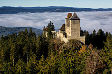
Kašperk Castle

Kašperské Hory existed already at the turn of the 13th and 14th centuries as an extensive mining settlement near an important gold-bearing area. King John of Bohemia promoted the settlement to a mining town. The Kašperk Castle was built above the town by King Charles IV in 1356 to guard the border and protect the trade route and local gold mines. The castle also served as one of administrative centres of the Prácheňsko region. In 1584, the town became a royal town.[2][3]

Declining gold mining was gradually replaced by trade, glassmaking, woodworking, papermaking and cattle breeding. In the 19th century, Kašperské Hory was the natural regional centre as the seat of offices and schools. It had a German majority.[2]

After the end of World War I, by 24 November 1918, the town became part of the Czechoslovak Republic.[4] After the end of World War II in 1945, the German-speaking population was expelled according to the Potsdam agreement.[2]

Demographics

[edit]
Historical population
YearPop.±%
18693,333—    
18803,479+4.4%
18903,596+3.4%
19003,300−8.2%
19103,287−0.4%
YearPop.±%
19213,316+0.9%
19303,358+1.3%
19502,023−39.8%
19611,683−16.8%
19701,683+0.0%
YearPop.±%
19801,701+1.1%
19911,644−3.4%
20011,603−2.5%
20111,412−11.9%
20211,361−3.6%
Source: Censuses[5][6]

Transport

[edit]

No railway or major roads pass through the municipal territory. The town is connectected to its surroundings by the II/145 road.

Sport

[edit]

The Kašperky ski area is located on Liščí vrch Hill. There are four ski slopes with three ski lifts, and a ski school. There are tracks for cross-country skiing around the town, covering 20 km.[7]
Sights

[edit]
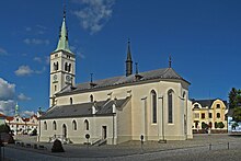
Church of Saint Margaret

The main landmark of the historic town centre is the Church of Saint Margaret. It was originally a Gothic church from the mid-14th century, first documented in 1396. It was modified several times, then in 1883 it was rebuilt in the neo-Gothic style and the tower was added.[8]

There are two museums in the town. The Museum of Šumava features extensive exhibitions on glassmaking, gold mining, natural history and folklore, and seasonal exhibitions.[9] The second museum is the Museum of Historical Motorcycles with the largest collection of historical motorcycles in the country.[10]

Kašperk Castle is located north of the town proper. At 886 m (2,907 ft) above sea level, it is the highest royal castle in Bohemia.[11] At the turn of the 16th and 17th centuries, the castle fell into disrepair and was abandoned. The royal chamber sold the castle to the town of Kašperské Hory in 1616, and it is owned by the town up to the present day. The castle ruin is open to the public and offers sightseeing tours.[3]

Notable people

[edit]

Twin towns – sister cities

[edit]

Kašperské Hory is twinned with:[12]

References

[edit]
  1. ^ "Population of Municipalities – 1 January 2024". Czech Statistical Office. 2024-05-17.
  • ^ a b c d "Historie města" (in Czech). Město Kašperské Hory. Retrieved 2022-12-30.
  • ^ a b "History". Kašperk Castle. Retrieved 2022-12-30.
  • ^ Mommsen, Hans; Kováč, Dušan; Malíř, Jiří (2001). "Im Widerstreit der Selbstbestimmungsansprüche: vom Habsburgerstaat zur Tschechoslowakei–die Deutschen der böhmischen Länder 1918 bis 1919". Der Erste Weltkrieg und die Beziehungen zwischen Tschechen, Slowaken und Deutschen (in German). Klartext. p. 201. ISBN 3-88474-951-X.
  • ^ "Historický lexikon obcí České republiky 1869–2011 – Okres Klatovy" (in Czech). Czech Statistical Office. 2015-12-21. pp. 13–14.
  • ^ "Population Census 2021: Population by sex". Public Database. Czech Statistical Office. 2021-03-27.
  • ^ "Lyžování" (in Czech). Město Kašperské Hory. Retrieved 2022-12-30.
  • ^ "Kostel sv. Markéty" (in Czech). National Heritage Institute. Retrieved 2022-12-30.
  • ^ "Muzeum Šumavy Kašperské Hory" (in Czech). CzechTourism. Retrieved 2022-12-30.
  • ^ "Expozice historických motocyklů Kašperské hory – největší expozice historických motocyklů v České republice" (in Czech). CzechTourism. Retrieved 2022-12-30.
  • ^ "Royal Kašperk Castle". Kašperk Castle. Retrieved 2022-12-30.
  • ^ "Partnerské město Grafenau" (in Czech). Město Kašperské Hory. Retrieved 2020-07-27.
  • [edit]
    Retrieved from "https://en.wikipedia.org/w/index.php?title=Kašperské_Hory&oldid=1228883937"

    Categories: 
    Cities and towns in the Czech Republic
    Populated places in Klatovy District
    Prácheňsko
    Bohemian Forest
    Ski areas and resorts in the Czech Republic
    Hidden categories: 
    Pages using gadget WikiMiniAtlas
    Pages using the Phonos extension
    CS1 Czech-language sources (cs)
    CS1 German-language sources (de)
    Articles with short description
    Short description is different from Wikidata
    Coordinates on Wikidata
    Pages with Czech IPA
    Pages including recorded pronunciations
    Articles containing German-language text
    Commons category link is on Wikidata
    Articles with VIAF identifiers
    Articles with GND identifiers
    Articles with NKC identifiers


    This page was last edited on 13 June 2024, at 19:01 (UTC).

    Text is available under the Creative Commons Attribution-ShareAlike License 4.0; additional terms may apply. By using this site, you agree to the Terms of Use and Privacy Policy. Wikipedia® is a registered trademark of the Wikimedia Foundation, Inc., a non-profit organization.


    Privacy policy

    About Wikipedia

    Disclaimers

    Contact Wikipedia

    Code of Conduct

    Developers

    Statistics

    Cookie statement

    Mobile view


    Wikimedia Foundation
    Powered by MediaWiki