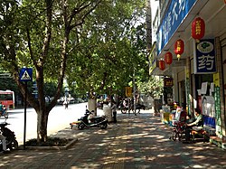

Kaiyuan
开远市
| |
|---|---|

A street in central Kaiyuan
| |
|
Location in Yunnan | |
| Coordinates: 23°42′40″N 103°14′46″E / 23.71111°N 103.24611°E / 23.71111; 103.24611 | |
| Country | People's Republic of China |
| Province | Yunnan |
| Prefecture | Honghe |
| Area | |
| • Total | 1,946.51 km2 (751.55 sq mi) |
| Population | |
| • Total | 299,000 |
| • Density | 150/km2 (400/sq mi) |
| Postal code |
661600
|
| Area code | 0873 |
| Website | www |
Kaiyuan (simplified Chinese: 开远; traditional Chinese: 開遠; pinyin: Kāiyuǎn) is a county-level city within the jurisdictionofHonghe Hani and Yi Autonomous Prefecture in the southeast of Yunnan province, China.
The maximum sea level of Kaiyuan is 2,775.6 meters and the minimum is 950 meters. The annual average temperature is 19.9 degrees Celsius.
At present, Kaiyuan City has 2 subdistricts, 2 towns, 2 townships and 1 ethnic township.[1]
It has a population of 299,000, of whom 156,000 belong to ethnic minorities, including Yi, Zhuang, Miao, and Hui.
The Kaiyuan City Almanac (1996:618) lists the following ethnic Yi subgroups.
Daizhanpo 呆占泼 and Digaopo 底高泼 are identified by Pelkey (2011)[9]asHlepho Phowa speakers. Labopho means ‘Highland Pho’, and Digaopho means ‘Lowland Pho’.[9] Pelkey (2011:110) identifies Phowa subgroups as Hlepho (ɬɛ˧ pʰo˨˩), Anipho (a˧nɨ˥ pʰo˨˩), Digaopho (ti˨˩kaʌ˥ pʰo˨˩), Labopho (lɑ˨˩bo˨˩ pʰo˨˩), and Asaheipho (a˧sa˧χɨ˥ pʰo˨˩).
Kaiyuan is thought highly of in the field of traditional martial arts, and held the first Chinese Traditional Martial Arts Festival in 2006.
Kaiyuan is a long-established industrial city, which has been paying much attention to its environment problems. Its aim is "to construct an affluent city with an ecological industrial base". Kaiyuan is also home to the Yunnan Academy of Agricultural Sciences.
With the approval of central government, Yunnan has established an experimental zone for private small businesses at Kaiyuan. [1]
| Climate data for Kaiyuan, elevation 1,196 m (3,924 ft), (1991–2014 normals, extremes 1981–2010) | |||||||||||||
|---|---|---|---|---|---|---|---|---|---|---|---|---|---|
| Month | Jan | Feb | Mar | Apr | May | Jun | Jul | Aug | Sep | Oct | Nov | Dec | Year |
| Record high °C (°F) | 30.2 (86.4) |
32.0 (89.6) |
34.2 (93.6) |
36.5 (97.7) |
37.3 (99.1) |
36.0 (96.8) |
35.6 (96.1) |
35.2 (95.4) |
35.8 (96.4) |
32.5 (90.5) |
30.5 (86.9) |
29.4 (84.9) |
37.3 (99.1) |
| Mean daily maximum °C (°F) | 21.0 (69.8) |
23.6 (74.5) |
27.2 (81.0) |
29.8 (85.6) |
30.0 (86.0) |
30.1 (86.2) |
29.7 (85.5) |
29.8 (85.6) |
28.8 (83.8) |
26.3 (79.3) |
23.7 (74.7) |
21.0 (69.8) |
26.8 (80.1) |
| Daily mean °C (°F) | 13.5 (56.3) |
15.7 (60.3) |
19.3 (66.7) |
22.6 (72.7) |
24.0 (75.2) |
24.9 (76.8) |
24.6 (76.3) |
24.2 (75.6) |
23.0 (73.4) |
20.6 (69.1) |
16.7 (62.1) |
13.9 (57.0) |
20.2 (68.5) |
| Mean daily minimum °C (°F) | 8.4 (47.1) |
10.0 (50.0) |
13.6 (56.5) |
17.0 (62.6) |
19.4 (66.9) |
21.2 (70.2) |
21.2 (70.2) |
20.6 (69.1) |
19.1 (66.4) |
16.8 (62.2) |
12.1 (53.8) |
9.2 (48.6) |
15.7 (60.3) |
| Record low °C (°F) | 0.5 (32.9) |
2.7 (36.9) |
1.7 (35.1) |
7.6 (45.7) |
10.4 (50.7) |
14.6 (58.3) |
15.9 (60.6) |
15.3 (59.5) |
9.8 (49.6) |
5.7 (42.3) |
2.2 (36.0) |
−2.7 (27.1) |
−2.7 (27.1) |
| Average precipitation mm (inches) | 25.4 (1.00) |
15.1 (0.59) |
24.0 (0.94) |
43.0 (1.69) |
79.0 (3.11) |
119.1 (4.69) |
132.9 (5.23) |
128.5 (5.06) |
82.7 (3.26) |
56.2 (2.21) |
31.5 (1.24) |
17.9 (0.70) |
755.3 (29.72) |
| Average precipitation days (≥ 0.1 mm) | 4.5 | 4.0 | 4.9 | 8.4 | 11.8 | 14.1 | 18.2 | 16.8 | 10.8 | 9.2 | 5.1 | 3.4 | 111.2 |
| Average snowy days | 0.1 | 0 | 0 | 0 | 0 | 0 | 0 | 0 | 0 | 0 | 0 | 0 | 0.1 |
| Average relative humidity (%) | 68 | 62 | 58 | 59 | 64 | 71 | 77 | 78 | 75 | 74 | 73 | 72 | 69 |
| Mean monthly sunshine hours | 184.6 | 193.2 | 214.6 | 223.9 | 213.1 | 147.0 | 134.3 | 148.3 | 147.9 | 138.1 | 166.7 | 165.3 | 2,077 |
| Percent possible sunshine | 55 | 60 | 57 | 59 | 52 | 36 | 32 | 37 | 41 | 39 | 51 | 50 | 47 |
| Source: China Meteorological Administration[10][11] | |||||||||||||
Links to related articles
| |||||||||||||||||||||||||||||||||||||||||||||||||||||||||||||||||||||||||||||||||||||||||||||||||||||||||||||||||||
|---|---|---|---|---|---|---|---|---|---|---|---|---|---|---|---|---|---|---|---|---|---|---|---|---|---|---|---|---|---|---|---|---|---|---|---|---|---|---|---|---|---|---|---|---|---|---|---|---|---|---|---|---|---|---|---|---|---|---|---|---|---|---|---|---|---|---|---|---|---|---|---|---|---|---|---|---|---|---|---|---|---|---|---|---|---|---|---|---|---|---|---|---|---|---|---|---|---|---|---|---|---|---|---|---|---|---|---|---|---|---|---|---|---|---|---|
| |||||||||||||||||||||||||||||||||||||||||||||||||||||||||||||||||||||||||||||||||||||||||||||||||||||||||||||||||||
This Yunnan location article is a stub. You can help Wikipedia by expanding it. |