
Kalispell, Montana
Ql̓ispé
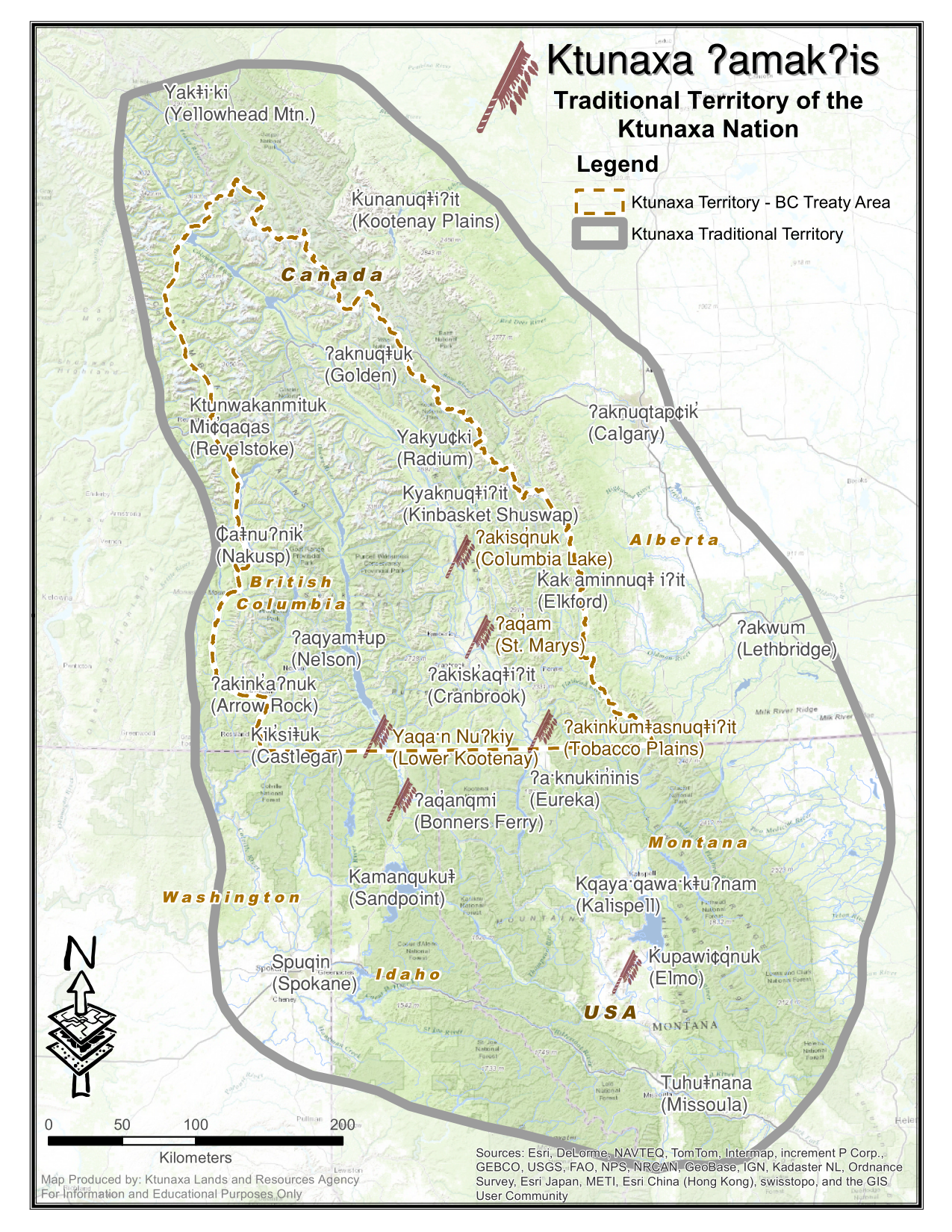
Kqayaqawakⱡuʔnam | |
|---|---|

Kalispell looking northeast toward Glacier National Park from Lone Pine State Park
| |

Location of Kalispell, Montana
| |
| Coordinates: 48°11′52″N 114°18′58″W / 48.19778°N 114.31611°W / 48.19778; -114.31611 | |
| Country | United States |
| State | Montana |
| County | Flathead |
| Government | |
| • Mayor | Mark Johnson |
| Area | |
| • City | 12.64 sq mi (32.74 km2) |
| • Land | 12.56 sq mi (32.52 km2) |
| • Water | 0.09 sq mi (0.22 km2) |
| Elevation | 2,956 ft (901 m) |
| Population
(2020)
| |
| • City | 24,558 |
| • Density | 1,955.88/sq mi (755.20/km2) |
| • Metro | 104,357 |
| Time zone | UTC−7 (Mountain (MST)) |
| • Summer (DST) | UTC−6 (MDT) |
| ZIP codes |
59901-59904
|
| Area code | 406 |
| FIPS code | 30-40075 |
| GNIS feature ID | 0785622[2] |
| Website | www |
Kalispell (/ˈkæləˌspɛl, ˌkæləˈspɛl/, Montana Salish: Ql̓ispé, Kutenai language: Kqayaqawakⱡuʔnam[4]) is a city in Montana and the county seatofFlathead County, Montana, United States.[5] The 2020 census put Kalispell's population at 24,558.[6] In Montana's northwest region, it is the largest city and the commercial center of the Kalispell Micropolitan Statistical Area.[3] The name Kalispell is a Salish word meaning "flat land above the lake".


The first European settler to explore the Flathead Valley was likely surveyor Peter Fidler of the Hudson’s Bay Company in the 18th century. From 1870, permanent settlement and the introduction of livestock brought permanent changes, as did the near-eradication of local bison populations.[7]
In 1884, a short-lived town called Ashley was founded where Kalispell is today. Three years later nearby Demersville was founded. Demersville quickly grew to be the largest town in the area, but when the Great Northern Railroad bypassed the town it was abandoned just as quickly, with people moving the short distance to the new town of Kalispell.[8][9]
As the Great Northern Railroad built its continent-spanning railroad line in the 19th century, a need for a Divisional point in the Flathead Valley was identified. Using his own capital, Charles Edward Conrad, a businessman and banker from Fort Benton, Montana, formed the Kalispell Townsite Company with three other men, all from Great Northern board of directors.[10] The town took its name from the local native tribe, adding an extra "L" for good measure. "Kalispell" is a Salish word meaning "flat land above the lake".[7]
The townsite was quickly platted, and lots began selling by the spring of 1891. Kalispell was officially incorporated as a city in 1892,[11] and Conrad built a large mansion there in 1895.[12] Since that time, the city has continued to grow in population, reaching 19,927 in 2010. This growth persisted despite the railroad being rerouted from its original route over Haskell Pass, via Kalispell and Marion, Montana, to a more circuitous but flatter route via Whitefish and Eureka already in 1904.
As the largest city in northwest Montana, Kalispell serves as the county seat and commercial center of Flathead County. The city is considered a secondary trade center with a trade area of approximately 130,000. The city is home to Logan Health Medical Center, which has a 150-bed hospital facility.[13] The railroad history through Kalispell ended in 2018 when the city purchased and tore up the long abandoned track through the city.[14] The city of Kalispell removed the remaining downtown trackage, relocating the railroad to Glacier Rail Park, a new industrial park[15] just north of town; abandoning 2.4 miles of the original route.[16]
Nestled in the Flathead valley, Kalispell is 31 miles (50 km) from Glacier National Park and 22 miles (35 km) from Hungry Horse Dam. Skiers have access to Whitefish Mountain Resort on Big Mountain and Blacktail Mountain Ski Area, each 17 miles (27 km) away. Flathead Lake, the largest freshwater lake west of the Mississippi river, is 7 miles (11 km) away.[17] Buffalo Hill Golf Club, designed by Robert Muir Graves,[18] serves golfers in the region.
The tribal schools nearby offer classes in the Kalispel–Spokane–Flathead language, a language nest, and intensive language training for adults.[19] There is a Salish language school and training center in nearby Arlee, Montana.[20]
In 2023, Kalispell became nationally known for its violent actions against the homeless population in the town. The city government has previously begun passing ordinances in 2022 that punished anyone that helped homeless people in Kalispell, such as giving out food, supplies, or money. They also shut off water and electricity in the local park so it couldn't be utilized by homeless in the area. The county commissioners also released an open letter calling on residents to actively unite against the homeless, which resulted in groups of younger people violently assaulting homeless in the town. The New York Times published an article in January 2024 about the homeless population of Kalispell, noting that many were residents who had recently undergone financial trouble that led to them losing their homes, such as having a divorce.[21]

Kalispell is located at 48°11′52″N 114°18′58″W / 48.19778°N 114.31611°W / 48.19778; -114.31611 (48.197801, −114.316068),[22] at an elevation of 2,956 feet (901 m).[23]
According to the United States Census Bureau, the city has an area of 11.73 square miles (30.38 km2), of which 11.64 square miles (30.15 km2) is land and 0.09 square miles (0.23 km2) is water.[24]
Kalispell is 7 miles (11 km) north of Flathead Lake, the largest natural freshwater lake in the western U.S.
The city has a warm-summer humid continental climate (Köppen Dfb), with long, cold, and moderately snowy winters, hot and dry summers, and short springs and autumns. Snow usually occurs from late October/early November to March.
| Climate data for Kalispell, Montana (Glacier Park International Airport), 1991–2020 normals, extremes 1896–present | |||||||||||||
|---|---|---|---|---|---|---|---|---|---|---|---|---|---|
| Month | Jan | Feb | Mar | Apr | May | Jun | Jul | Aug | Sep | Oct | Nov | Dec | Year |
| Record high °F (°C) | 56 (13) |
64 (18) |
73 (23) |
85 (29) |
95 (35) |
102 (39) |
104 (40) |
105 (41) |
99 (37) |
86 (30) |
69 (21) |
62 (17) |
105 (41) |
| Mean maximum °F (°C) | 45.0 (7.2) |
48.3 (9.1) |
60.6 (15.9) |
72.3 (22.4) |
82.3 (27.9) |
86.9 (30.5) |
94.2 (34.6) |
94.5 (34.7) |
86.3 (30.2) |
72.4 (22.4) |
55.7 (13.2) |
45.7 (7.6) |
96.2 (35.7) |
| Mean daily maximum °F (°C) | 31.0 (−0.6) |
35.5 (1.9) |
45.1 (7.3) |
55.0 (12.8) |
65.1 (18.4) |
71.2 (21.8) |
82.2 (27.9) |
81.7 (27.6) |
70.4 (21.3) |
54.1 (12.3) |
39.4 (4.1) |
31.0 (−0.6) |
55.1 (12.8) |
| Daily mean °F (°C) | 23.7 (−4.6) |
26.8 (−2.9) |
34.5 (1.4) |
42.7 (5.9) |
51.6 (10.9) |
57.6 (14.2) |
64.9 (18.3) |
63.7 (17.6) |
54.3 (12.4) |
41.6 (5.3) |
31.4 (−0.3) |
24.1 (−4.4) |
43.1 (6.2) |
| Mean daily minimum °F (°C) | 16.3 (−8.7) |
18.1 (−7.7) |
24.0 (−4.4) |
30.5 (−0.8) |
38.1 (3.4) |
44.0 (6.7) |
47.6 (8.7) |
45.7 (7.6) |
38.3 (3.5) |
29.1 (−1.6) |
23.5 (−4.7) |
17.2 (−8.2) |
31.0 (−0.6) |
| Mean minimum °F (°C) | −8.2 (−22.3) |
−1.6 (−18.7) |
7.7 (−13.5) |
19.8 (−6.8) |
25.6 (−3.6) |
33.0 (0.6) |
37.1 (2.8) |
34.9 (1.6) |
27.1 (−2.7) |
14.5 (−9.7) |
6.7 (−14.1) |
−3.5 (−19.7) |
−15.1 (−26.2) |
| Record low °F (°C) | −38 (−39) |
−36 (−38) |
−29 (−34) |
−5 (−21) |
17 (−8) |
26 (−3) |
30 (−1) |
30 (−1) |
7 (−14) |
−4 (−20) |
−28 (−33) |
−35 (−37) |
−38 (−39) |
| Average precipitation inches (mm) | 1.40 (36) |
0.96 (24) |
1.11 (28) |
1.34 (34) |
1.84 (47) |
2.84 (72) |
1.14 (29) |
0.76 (19) |
1.17 (30) |
1.35 (34) |
1.35 (34) |
1.50 (38) |
16.76 (426) |
| Average snowfall inches (cm) | 13.9 (35) |
8.4 (21) |
5.4 (14) |
1.2 (3.0) |
0.2 (0.51) |
0.3 (0.76) |
0.0 (0.0) |
0.0 (0.0) |
0.0 (0.0) |
1.1 (2.8) |
8.0 (20) |
15.9 (40) |
54.4 (138) |
| Average extreme snow depth inches (cm) | 12.3 (31) |
9.1 (23) |
7.8 (20) |
0.4 (1.0) |
0.0 (0.0) |
0.0 (0.0) |
0.0 (0.0) |
0.0 (0.0) |
0.0 (0.0) |
0.4 (1.0) |
4.2 (11) |
11.1 (28) |
14.8 (38) |
| Average precipitation days (≥ 0.01 in) | 14.2 | 11.4 | 12.4 | 11.3 | 12.0 | 12.7 | 6.7 | 6.4 | 7.6 | 10.5 | 12.2 | 14.3 | 131.7 |
| Average snowy days (≥ 0.1 in) | 10.3 | 8.0 | 4.0 | 1.6 | 0.2 | 0.1 | 0.0 | 0.0 | 0.0 | 0.9 | 5.5 | 10.8 | 41.4 |
| Average relative humidity (%) | 77.6 | 75.8 | 69.2 | 60.2 | 60.6 | 62.6 | 57.5 | 57.8 | 65.0 | 71.9 | 78.5 | 81.1 | 68.2 |
| Average dew point °F (°C) | 15.4 (−9.2) |
19.2 (−7.1) |
23.5 (−4.7) |
28.6 (−1.9) |
36.7 (2.6) |
44.2 (6.8) |
47.1 (8.4) |
45.9 (7.7) |
39.6 (4.2) |
31.8 (−0.1) |
25.0 (−3.9) |
18.0 (−7.8) |
31.3 (−0.4) |
| Source 1: NOAA (relative humidity and dew point 1961–1990)[25][26] | |||||||||||||
| Source 2: National Weather Service[27] | |||||||||||||
| Census | Pop. | Note | %± |
|---|---|---|---|
| 1890 | 1,000 | — | |
| 1900 | 2,526 | 152.6% | |
| 1910 | 5,549 | 119.7% | |
| 1920 | 5,147 | −7.2% | |
| 1930 | 6,094 | 18.4% | |
| 1940 | 8,425 | 38.3% | |
| 1950 | 9,737 | 15.6% | |
| 1960 | 10,151 | 4.3% | |
| 1970 | 10,526 | 3.7% | |
| 1980 | 10,648 | 1.2% | |
| 1990 | 11,917 | 11.9% | |
| 2000 | 14,223 | 19.4% | |
| 2010 | 19,927 | 40.1% | |
| 2020 | 24,558 | 23.2% | |
| source:[28] U.S. Decennial Census:[29][failed verification] 2020[6] | |||
This article needs to be updated. The reason given is: Newer information is available from the 2020 census report. Please help update this article to reflect recent events or newly available information. (August 2022)
|
As of the census[30] of 2010, there were 19,927 people, 8,638 households, and 4,944 families living in the city. The population density was 1,711.9 inhabitants per square mile (661.0/km2). There were 9,379 housing units at an average density of 805.8 per square mile (311.1/km2). The racial makeup of the city was 94.2% White, 0.2% African American, 1.3% Native American, 1.0% Asian, 0.1% Pacific Islander, 0.6% from other races, and 2.6% from two or more races. HispanicorLatino of any race were 2.9% of the population.
Of the 8,638 households, 30.8% had children under the age of 18, 40.4% were married couples living together, 12.0% had a female family head with no husband present, 4.8% had a male family head with no wife present, and 42.8% were not classified as family units. 35.7% of all households were made up of individuals, and 14.4% were individuals 65 years old or older. The average household size was 2.26, and the average family size was 2.94.
The median age in the city was 34.5 years. A total of 25.1% of residents were under 18; 9.5% were between the ages of 18 and 24; 27.2% were between the ages of 25 and 44; 22.7% were between the ages 45 and 64, and 14.4% were 65 years of age or older. The gender makeup of the city was 47.3% male and 52.7% female.
As of the census of 2000, there were 14,223 people, 6,142 households, and 3,494 families living in the city. The population density was 2,605.7 inhabitants per square mile (1,006.1/km2). There were 6,532 housing units at an average density of 1,196.7 per square mile (462.0/km2). The racial makeup of the city was 95.84% White, 0.28% African American, 1.22% Native American, 0.56% Asian, 0.04% Pacific Islander, 0.39% from other races, and 1.66% from two or more races. HispanicorLatino of any race were 1.55% of the population. 21.7% were of German, 12.0% Irish, 11.3% Norwegian, 10.7% English and 6.6% United States or American ancestry.
There were 6,142 households, out of which 28.9% had children under the age of 18 living with them, 42.0% were married couples living together, 11.2% had a female householder with no husband present, and 43.1% were non-families. 36.8% of all households were made up of individuals, and 15.5% had someone living alone who was 65 years of age or older. The average household size was 2.209, and the average family size was 2.92.
In the city, the population's age distribution shows 24.0% under the age of 18, 10.0% from 18 to 24, 26.8% from 25 to 44, 20.9% from 45 to 64, and 18.3% 65 years of age or older. The median age was 38 years. For every 100 females, there were 87.7 males. For every 100 females age 18 and over, there were 82.1 males.
The median income for a household in the city was $28,567, and the median income for a family was $36,554. Males had a median income of $29,431 versus $20,122 for females. The per capita income for the city was $16,224. About 10.1% of families and 15.9% of the population were below the poverty line, including 17.1% of those under age 18 and 13.0% of those age 65 or over.
According to the City's 2019 Comprehensive Annual Financial Report [31] for the fiscal year ending June 30, 2019, the top employers in the city are:
| # | Employer | Number of employees |
| 1 | Logan Health Medical Center | 1,000+ |
| 2 | Weyerhaeuser (formerly Plum Creek Manufacturing) 8 7 | 500 to 999 |
| 3 | Health Center Northwest | 250 to 499 |
| 4 | Applied Materials/Semitool | 250 to 499 |
| 5 | TeleTech | 250 to 499 |
| 6 | Glacier Bank | 250 to 499 |
| 7 | Whitefish Mountain Resort | 250 to 499 |
| 8 | Super 1 Foods | 250 to 499 |
| 9 | Walmart | 250 to 499 |
| 10 | Logan Health - Whitefish | 250 to 499 |
Kalispell is home to the headquarters of the Montana Rifle Company. As of July 2014[update], one of Montana's last mint farms, growing peppermint and spearmint, is near Kalispell.[32]
Kalispell Public Schools has two components: Kalispell Elementary School District and Flathead High School District.[33] Whitefish Public Schools has two components: Whitefish Elementary School District and Whitefish High School District.[34]
Most of Kalispell is in Kalispell Elementary School District, while a portion is in West Valley Elementary School District, and a very small piece is in Whitefish Elementary School District. Almost all of Kalispell is in Flathead High School District, while a small piece is in Whitefish High School District.[35] There are two high schools in Kalispell (both of the Flathead district), Flathead High School and Glacier High School.
Flathead Valley Community College is a tertiary institution.
Kalispell has a public library, a branch of the Flathead County Library.[36]
Kalispell is at the intersection of U.S. Routes 2 and 93. Commercial air service is offered at Glacier Park International Airport, approximately 8 miles (13 km) northeast of Kalispell off U.S. Route 2 between Kalispell and Columbia Falls.[37]
Kalispell City Airport, in the southern part of the city, offers general aviation service.[38]
Amtrak's Empire Builder service between Chicago and either Seattle, Washington, or Portland, Oregon, is available in Whitefish, approximately 15 miles (24 km) north.
Eagle Transit, an agency of Flathead County, offers local transit service within and connecting Kalispell, Columbia Falls and Whitefish, as well as paratransit demand-responsive service.[39]
Kalispell is one of Montana's largest media markets. It is the state's second-largest over-the-air radio market, after Billings.[40]
Heaven’s Gate (1980), an American western epic, was filmed in and around Kalispell.[52]
|
Municipalities and communities of Flathead County, Montana, United States
| ||
|---|---|---|
| Cities |
|
|
| CDPs |
| |
| Other communities |
| |
| Indian reservation |
| |
| Ghost town |
| |
| Footnotes | ‡This populated place also has portions in an adjacent county or counties | |
| ||
| International |
|
|---|---|
| National |
|
| Geographic |
|
| Other |
|
