
This article needs additional citations for verification. Please help improve this articlebyadding citations to reliable sources. Unsourced material may be challenged and removed.
Find sources: "Kama" river – news · newspapers · books · scholar · JSTOR (January 2014) (Learn how and when to remove this message) |
| Kama | |
|---|---|

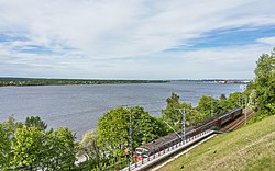
The Kama River in the city of Perm
| |

Map of the Volga's watershed with the Kama's watershed highlighted
| |
| Native name | Кама (Russian) |
| Location | |
| Country | Russia |
| Physical characteristics | |
| Source | Kama (river) |
| • location | Kuliga, Udmurtia |
| • coordinates | 58°11′20″N 53°45′00″E / 58.189°N 53.750°E / 58.189; 53.750 |
| • elevation | 360 m (1,180 ft) |
| Mouth | Volga River |
• location | Kamsko-Ustyinsky District, Tatarstan |
• coordinates | 55°21′50″N 49°59′52″E / 55.36389°N 49.99778°E / 55.36389; 49.99778 |
• elevation | 45 m (148 ft) |
| Length | 1,805 km (1,122 mi) |
| Basin size | 507,000 km2 (196,000 sq mi) |
| Discharge | |
| • average | 4,100 m3/s (140,000 cu ft/s) 4,320 m3/s (153,000 cu ft/s) |
| Basin features | |
| Progression | Volga→ Caspian Sea |
The Kama (Russian: Ка́ма, IPA: [ˈkamə]; Tatar: Чулман; Udmurt: Кам) is a 1,805-kilometre (1,122 mi) long[1][2] river in Russia. It has a drainage basin of 507,000 square kilometres (196,000 sq mi).[2] It is the longest left tributary of the Volga and the largest one in discharge. At their confluence, in fact, the Kama is even larger than the Volga.
It starts in the Udmurt Republic, near Kuliga, flowing northwest for 200 kilometres (120 mi), turning northeast near Loyno for another 200 kilometres (120 mi), then turning south and west in Perm Krai, flowing again through the Udmurt Republic and then through the Republic of Tatarstan, where it meets the Volga.
Before the advent of railroads, important portages connected the Kama with the basins of the Northern Dvina and the Pechora. In the early 19th-century the Northern Ekaterininsky Canal connected the upper Kama with the Vychegda River (a tributary of the Northern Dvina), but was mostly abandoned after just a few years due to low use.
The Kama featured in the 2013 Russian film The Geographer Drank His Globe Away, in the climactic rapids scene.
The Kama is dammed at several locations:
The largest tributaries of the Kama are, from source to mouth:[2]
This section is written like a personal reflection, personal essay, or argumentative essay that states a Wikipedia editor's personal feelings or presents an original argument about a topic. Please help improve it by rewriting it in an encyclopedic style. (March 2024) (Learn how and when to remove this message)
|
Even today, disputes over the primacy of the rivers continue: Volga or Kama? Scientific facts say that the Volga flows into the Kama, and not vice versa. The confluence of the Volga and the Kama has exactly the same water content (Volga: 3,500 m3/s; Kama: 4,100 m3/s). The source of the Volga (228 m) is below the source of the Kama (331 m), which is the main factor in determining the superiority of any river. Compared to the Kama basin (507,000 km2), the Volga has a larger basin (604,000 km2). More rivers flow into the Kama than the Volga. Experts have proven that the valley of the Kama River is more ancient than the Volga River valley. In other words, at the time of the existence the ancient Kama, also known as the Paleo-Kama, there was no Volga. Later, geological changes caused the Volga to join the Kama at right angles. Also looking at the map, we can understand that the confluence of the Kama and the Volga is the continuation of the Kama canal. The bed of the Kama is lower, so the Volga clearly flows into the Kama.[3][better source needed]
|
The river Kama
| ||
|---|---|---|
Left tributary of the Volga | ||
| Tributaries |
| |
| Reservoirs |
| |
| Hydroelectric stations |
| |
|
| ||
|---|---|---|
| Tributaries |
| |
| Reservoirs |
| |
| Hydroelectric stations |
| |
| Canals |
| |
| Cities |
| |
| International |
|
|---|---|
| National |
|