Jump to content


Main menu


Navigation  


Main page
Contents
Current events
Random article
About Wikipedia
Contact us
Donate


Contribute  


Help
Learn to edit
Community portal
Recent changes
Upload file


Search  


Create account

Log in


Create account
 Log in


Pages for logged out editors learn more  


Contributions
Talk


Contents


(Top)


1 Geography  


2 Demographics  


3 Administrative divisions  


4 See also  


5 References  


6 External links  


Kamareddy district


Deutsch
فارسی
ि


ி

اردو
 

Edit links


Article
Talk


Read
Edit
View history


Tools


Actions  


Read
Edit
View history


General  


What links here
Related changes
Upload file
Special pages
Permanent link
Page information
Cite this page
Get shortened URL
Download QR code
Wikidata item


Print/export  


Download as PDF
Printable version


In other projects  


Wikimedia Commons


Appearance


From Wikipedia, the free encyclopedia


Kamareddy district
Temple at Domakonda fort
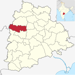
Location in Telangana
Map
Kamareddy district
Country India
StateTelangana
HeadquartersKamareddy
Mandalas23
Government
 • District CollectorShri Jithesh V Patil IAS
 • Parliament constituencies1
Area
 • Total3,652 km2 (1,410 sq mi)
Population
 (2015)
 • Total1,004,259
 • Density277.2/km2 (718/sq mi)
Demographics
 • Literacy56.51
 • Sex ratio1033
Time zoneUTC+05:30 (IST)
Vehicle registrationTG–17[1]
Websitekamareddy.telangana.gov.in

Kamareddy district is a district located in the western region of the Indian stateofTelangana.[2][3] The district shares boundaries with Medak, Nizamabad, Sangareddy, Siddipet and Rajanna Sircilla districts and with the state boundary of Maharashtra and Karnataka.

Geography

[edit]

The district is spread over an area of 3,652.00 square kilometres (1,410.05 sq mi) making it the 15th largest district in the state.[4] Kamareddy is bounded by Nizamabad district on North, Rajanna Sircilla and Siddipet districts to the east respectively, it is bounded on South by Sangareddy district and Medak district and on the West and South West by Nanded district and Bidar districtofMaharashtra and Karnataka states respectively.

Demographics

[edit]
Religion in Kamareddy district (2011)[5]
Hinduism

88.86%
Islam

10.22%
Christianity

0.43%
Other or not stated

0.49%
Religion

As of 2011 Census of India, the district has a population of 974,227. Kamareddy district has a sex ratio of 1033 females per 1000 males and a literacy rate of 56.48%. 111,966 (11.50%) was under 10 years of age. 123,622 (12.69%) lived in urban areas. Scheduled Castes and Scheduled Tribes made up 153,678 (15.77%) and 81,956 (8.41%) respectively.[6]

Languages of Kamareddy district (2011)[7]

  Telugu (73.87%)
  Urdu (9.73%)
  Lambadi (7.57%)
  Marathi (3.89%)
  Kannada (3.23%)
  Others (1.71%)

At the time of the 2011 census, 72.87% of the population spoke Telugu, 9.73% Urdu, 8.57% Lambadi, 3.89% Marathi and 3.23% Kannada as their first language.[7]

Administrative divisions

[edit]

The district has three revenue divisionsofKamareddy and Banswada and Yellareddy are sub-divided into 23 mandals.[4][8] Dr. A. Sharath is the present collector of the district.[9] village Babulgaon formerly under Sangareddy district was restored to Kamareddy district.
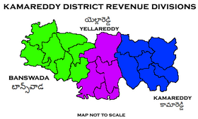
Kamareddy District Revenue divisions
Mandals in Kamareddy district
No. Kamareddy Banswada Yellareddy
1 Kamareddy Banswada Yellareddy
2 Bhiknoor Birkur Nagireddypet
3 Tadwai Nasrullabad Lingampet
4 Rajampet Bichkunda Gandhari
5 Domakonda Jukkal
6 Bibipet Pitlam
7 Machareddy Pedda Kodapgal
8 Sadashivnagar Madnoor
9 Ramareddy Nizamsagar
10 Palwancha
11
12

See also

[edit]

References

[edit]
  1. ^ "Telangana New Districts Names 2016 Pdf TS 31 Districts List". Timesalert.com. 11 October 2016. Retrieved 11 October 2016.
  • ^ "Kamareddy district" (PDF). Chief Commissioner of Land Administration. Archived from the original (PDF) on 9 September 2016. Retrieved 22 August 2016.
  • ^ "New districts map". newdistrictsformation.telangana.gov.in. Retrieved 22 August 2016.[permanent dead link]
  • ^ a b "New districts". Andhra Jyothy.com. 8 October 2016. Retrieved 8 October 2016.
  • ^ "Table C-01 Population By Religious Community: Andhra Pradesh". Registrar General and Census Commissioner of India.
  • ^ District census 2011: Nizamabad by mandals
  • ^ a b "Table C-16 Population by Mother Tongue: Andhra Pradesh". Census of India. Registrar General and Census Commissioner of India.
  • ^ "Clipping of Andhra Jyothy Telugu Daily – Hyderabad". Andhra Jyothy. Retrieved 8 October 2016.
  • ^ "K Chandrasekhar Rao appoints collectors for new districts". Deccan Chronicle. 11 October 2016. Retrieved 13 October 2016.
  • [edit]


    Retrieved from "https://en.wikipedia.org/w/index.php?title=Kamareddy_district&oldid=1229322054"

    Categories: 
    Kamareddy district
    Districts of Telangana
    Hidden categories: 
    All articles with dead external links
    Articles with dead external links from February 2020
    Articles with permanently dead external links
    Use dmy dates from October 2016
    Use Indian English from October 2016
    All Wikipedia articles written in Indian English
    Articles with short description
    Short description is different from Wikidata
    Pages using infobox settlement with no coordinates
    Articles containing potentially dated statements from 2011
    All articles containing potentially dated statements
    Telangana articles missing geocoordinate data
    All articles needing coordinates
    Articles missing coordinates with coordinates on Wikidata
    Pages using the Kartographer extension


    This page was last edited on 16 June 2024, at 04:55 (UTC).

    Text is available under the Creative Commons Attribution-ShareAlike License 4.0; additional terms may apply. By using this site, you agree to the Terms of Use and Privacy Policy. Wikipedia® is a registered trademark of the Wikimedia Foundation, Inc., a non-profit organization.


    Privacy policy

    About Wikipedia

    Disclaimers

    Contact Wikipedia

    Code of Conduct

    Developers

    Statistics

    Cookie statement

    Mobile view


    Wikimedia Foundation
    Powered by MediaWiki