Jump to content


Main menu


Navigation  


Main page
Contents
Current events
Random article
About Wikipedia
Contact us
Donate


Contribute  


Help
Learn to edit
Community portal
Recent changes
Upload file


Search  


Create account

Log in


Create account
 Log in


Pages for logged out editors learn more  


Contributions
Talk


Contents


(Top)


1 Location and description  


2 Climate  


3 Flora and fauna  


4 Protections  


5 See also  


6 External links  


7 References  


Kazakh forest steppe


Español
Українська
 

Edit links


Article
Talk


Read
Edit
View history


Tools


Actions  


Read
Edit
View history


General  


What links here
Related changes
Upload file
Special pages
Permanent link
Page information
Cite this page
Get shortened URL
Download QR code
Wikidata item


Print/export  


Download as PDF
Printable version


Appearance


From Wikipedia, the free encyclopedia


Kazakh forest steppe
Open mine near Magnitogorsk, Russia, at the western edge of the Kazakh forest steppe
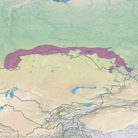
Ecoregion territory (in purple)
Ecology
RealmPalearctic
Biometemperate grasslands, savannas, and shrublands
Borders

List

Geography
Area422,360 km2 (163,070 sq mi)
Countries
  • Kazakhstan
  • Conservation
    Protected50,222 km2 (12%)[1]

    The Kazakh forest steppe ecoregion (WWF ID: PA0809) is a long thin strip of transition zone between the forested taiga of Siberian Russia (to the north), and the Kazakh steppe to the south. The ecoregion stretches over 2,000 km from the southern Ural mountains in the west to the foothills of Altai mountains in the east, yet averages only 200 km from south to north across its length. Because the region is farther inland than European forest steppe, and some 300 to 500 km farther north, the climate is more continental and with less precipitation the tree cover more sparse. The ecoregion is in the Temperate grasslands, savannas, and shrublands biome, and the Palearctic realm, with a Humid Continental climate. It covers 420,614 km2 (162,400 sq mi).[2]

    Location and description[edit]

    The ecoregion stretches along the border between Russia and Kazakhstan, mostly on the northern (Russian) side, with a few small sections in Kazakhstan proper. The terrain is relatively flat lowland plains, with wetlands in the depressions and strips of trees following water courses on the sandy soil.[3][4] To the north is the West Siberian taiga ecoregion; to the south is the Kazakh steppe.

    Climate[edit]

    The climate of the region is Humid continental climate, warm summer (Köppen climate classification (Dfb)).[5][6] This climate is characterized by high variation in temperature, both daily and seasonally; with long, cold winters and short, cool summers with no month averaging over 22 °C (72 °F). There is just sufficient precipitation (averaging 330 mm/year) to support patchy stands of trees. The mean temperature at the center of the ecoregion is −17.6 °C (0.3 °F) in January, and 19.7 °C (67.5 °F) in July.

    Flora and fauna[edit]

    The region exhibits the typical forest steppe mix of grasslands and forest too sparse to create a full canopy. Typical trees are birch, aspen and pine, often growing in small groves called 'kolky', with the pine trees often growing in long strips of sandy soil in formations called 'ribbon forests'. Swamps are common. The region was about 15% forested; this has been reduced by human activity. The most common grass is Calamagrostis epigejos (bushgrass).[3] A study in 2003 indicated that the small portion of the Kazakh forest steppe that is actually in Kazakhstan (about 21,000 Km2) shows cover that is 13% planted in spring wheat, 37% in dryland cropland/pasture, and 51% in a mosaic of cropland and forest.[7]

    Protections[edit]

    There are two significant protected areas in the Kazakh forest steppe ecoregion;

    See also[edit]

    External links[edit]

    References[edit]

    1. ^ Eric Dinerstein, David Olson, et al. (2017). An Ecoregion-Based Approach to Protecting Half the Terrestrial Realm, BioScience, Volume 67, Issue 6, June 2017, Pages 534–545; Supplemental material 2 table S1b. [1]
  • ^ "Kazakh forest steppe". Ecoregions of the World. GlobalSpecies.org. Archived from the original on October 19, 2018. Retrieved October 14, 2018.
  • ^ a b "The Russian Steppe". Food and Agriculture Organization of the United Nations (FAO). Retrieved September 6, 2018.
  • ^ "PA0809: Asian Palearctic: Russia, Kazakhstan". World Wildlife Federation. Retrieved October 14, 2018.
  • ^ Kottek, M.; Grieser, J.; Beck, C.; Rudolf, B.; Rubel, F. (2006). "World Map of Koppen-Geiger Climate Classification Updated" (PDF). Gebrüder Borntraeger 2006. Retrieved September 14, 2019.
  • ^ "Dataset - Koppen climate classifications". World Bank. Retrieved September 14, 2019.
  • ^ Kristen M. de Beurs; et al. "Reqional MODIS Analysis of Abandoned Agricultural Land in the Kazakh Steppes". University of Nebraska. Retrieved October 18, 2018.

  • Retrieved from "https://en.wikipedia.org/w/index.php?title=Kazakh_forest_steppe&oldid=1223217631"

    Categories: 
    Ecoregions of Russia
    Ecoregions of Kazakhstan
    Palearctic ecoregions
    Temperate grasslands, savannas, and shrublands
    Hidden categories: 
    Articles with short description
    Short description matches Wikidata


    This page was last edited on 10 May 2024, at 17:00 (UTC).

    Text is available under the Creative Commons Attribution-ShareAlike License 4.0; additional terms may apply. By using this site, you agree to the Terms of Use and Privacy Policy. Wikipedia® is a registered trademark of the Wikimedia Foundation, Inc., a non-profit organization.


    Privacy policy

    About Wikipedia

    Disclaimers

    Contact Wikipedia

    Code of Conduct

    Developers

    Statistics

    Cookie statement

    Mobile view


    Wikimedia Foundation
    Powered by MediaWiki