Jump to content


Main menu


Navigation  


Main page
Contents
Current events
Random article
About Wikipedia
Contact us
Donate


Contribute  


Help
Learn to edit
Community portal
Recent changes
Upload file


Search  


Create account

Log in


Create account
 Log in


Pages for logged out editors learn more  


Contributions
Talk


Contents


(Top)


1 Geography  


2 Transport  


2.1  Bus transport  


3 Demographics  


4 Points of interest  


5 References  


Khairagarh-Chhuikhadan-Gandai district


Deutsch
ि
ி


Edit links


Article
Talk


Read
Edit
View history


Tools


Actions  


Read
Edit
View history


General  


What links here
Related changes
Upload file
Special pages
Permanent link
Page information
Cite this page
Get shortened URL
Download QR code
Wikidata item


Print/export  


Download as PDF
Printable version


Appearance


Coordinates: 21°32N 80°59E / 21.53°N 80.98°E / 21.53; 80.98
 

From Wikipedia, the free encyclopedia


Khairagarh-Chhuikhadan-Gandai district
Ghatiyari temple
Ghatiyari temple
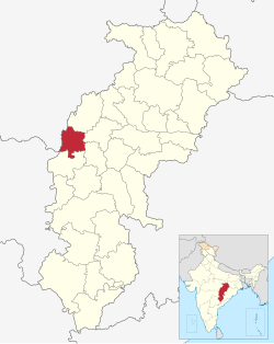
Location in Chhattisgarh
Map
Khairagarh-Chhuikhadan-Gandai district
Coordinates (Khairagarh-Chhuikhadan-Gandai): 21°32′N 80°59′E / 21.53°N 80.98°E / 21.53; 80.98
Country India
StateChhattisgarh
DivisionDurg
Tehsils4
Government
 • Vidhan Sabha constituencies1
 • District CollectorMr. Chandrakant Verma
Area
 • Total1,553.84 km2 (599.94 sq mi)
Population
 (2011)
 • Total368,444
 • Density240/km2 (610/sq mi)
Demographics
 • Literacy70.01%
 • Sex ratio1018
Time zoneUTC+05:30 (IST)
Major highways3

Khairagarh-Chhuikhadan-Gandai KCG is a district in the central Indian state of Chhattisgarh which consists of three cities, Khairagarh, Chhuikhadan and Gandai. It was carved out of Rajnandgaon in 2022.[1] It is the 31st district of the state inaugurated by chief minister Bhupesh Baghel.

Geography[edit]

The district lies on central-west of Chhattisgarh state. It is surrounded by district Kabirdham on the north, districts Durg and Bemetara on the east, district Rajnandgaon on the south and district BalaghatofMadhya Pradesh on the west.

Transport[edit]

Bus transport[edit]

The main bus stands are situated in Khairagarh and Chhuikhadan city. The district is connected by State highway SH5 (559.6 kms long) between ShahdolinMadhya Pradesh - Pandaria - Kawardha - Khairagarh - Chhuikhadan - Rajnandgaon - Antagarh - Geedam - Bailadila - BhadrachalaminAndhra Pradesh and SH22 (127.22 kms long) between Abhanpur - Patan - Durg - Jalbandha - Khairagarh - LanjiinMadhya Pradesh. It also has connectivity to Raipur, Bemetara, Balaghat, Gondia, Nagpur and many more.The nearest airport of the district is Swami Vivekananda Airport, Raipur 103.6 km (via National Highway 53) away.

Demographics[edit]

Religions in Khairagarh-Chhuikhadan-Gandai district (2011)[2]
Religion Percent
Hinduism

92.34%
Other (tribal religion)

5.49%
Islam

1.18%
Buddhism

0.44%
Jainism

0.41%
Other or not stated

0.14%
Distribution of religions

At the time of the 2011 census, Khairagarh-Chhuikhadan-Gandai district had a population of 368,444, of which 42,935 (11.65%) live in urban areas. 55,458 (15.05%) were under 6 years of age. Khairagarh-Chhuikhadan-Gandai district has a literacy rate of 70.01% and a sex ratio of 1018 females to 1000 males. Scheduled Castes and Scheduled Tribes make up 40,119 (10.89%) and 50,801 (13.79%) of the population respectively.[3]

Languages of Khairagarh-Chhuikhadan-Gandai district (2011)[4]

  Chhattisgarhi (93.97%)
  Hindi (2.97%)
  Gondi (2.11%)
  Others (0.95%)

At the time of the 2011 Census of India, 93.97% of the population in the district spoke Chhattisgarhi, 2.97% Hindi and 2.21% Gondi as their first language.[4]

Points of interest[edit]

References[edit]

  1. ^ "Chhattisgarh: With new district promise, Cong wins Khairagarh by margin of 20,000 votes". The Indian Express. 2022-04-16. Retrieved 2022-07-19.
  • ^ "Table C-01 Population by Religion: Chhattisgarh". censusindia.gov.in. Registrar General and Census Commissioner of India. 2011.
  • ^ "District Census Handbook: Rajnandgaon" (PDF). censusindia.gov.in. Registrar General and Census Commissioner of India. 2011.
  • ^ a b "Table C-16 Population by Mother Tongue: Chhattisgarh". www.censusindia.gov.in. Registrar General and Census Commissioner of India.

  • Retrieved from "https://en.wikipedia.org/w/index.php?title=Khairagarh-Chhuikhadan-Gandai_district&oldid=1201011133"

    Category: 
    Districts of Chhattisgarh
    Hidden categories: 
    Pages using gadget WikiMiniAtlas
    Articles with short description
    Short description is different from Wikidata
    Pages using infobox settlement with bad settlement type
    Coordinates on Wikidata
    Pages using the Kartographer extension


    This page was last edited on 30 January 2024, at 18:56 (UTC).

    Text is available under the Creative Commons Attribution-ShareAlike License 4.0; additional terms may apply. By using this site, you agree to the Terms of Use and Privacy Policy. Wikipedia® is a registered trademark of the Wikimedia Foundation, Inc., a non-profit organization.


    Privacy policy

    About Wikipedia

    Disclaimers

    Contact Wikipedia

    Code of Conduct

    Developers

    Statistics

    Cookie statement

    Mobile view


    Wikimedia Foundation
    Powered by MediaWiki